
Yesterday I made a trip to the Museum of the City of New York to see The Greatest Grid. This exhibit celebrates the 200th anniversary of the Commissioner's Plan of 1811 that established the city's grid system. The exhibit is full of historic maps and the centerpiece is the Commissioners Plan Map of 1811 laid out on a glass covered table.

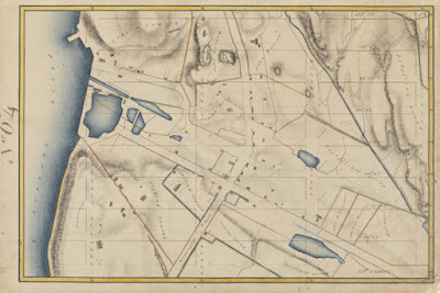
The grid was placed over the more sparsely settled areas above North Street (now Houston) without regard to the city's topography, water features or existing houses. Villages such as Harlem were eliminated to make room for straight streets. Houses that stood in the way (or even near the way) were demolished or moved. There is a section of the exhibit showing how houses were moved to accommodate the grid. This map from the exhibit's web site is one of many that show the land before the streets were built with the grid superimposed in light gray.
The exhibit starts with a video loop of residents proudly stating their address along the grid eg."125th and First!" After spending hours gawking at the maps you can go upstairs and see The Unfinished Grid, a collection of future design speculations resulting from a call for ideas from the Architectural League of New York. Many of these designs revolve around ways to break free from the grid's restrictions.
This collection of maps, photographs, newspaper clippings and other artifacts is very impressive and well worth a visit if you are in the New York metropolitan area. It runs through April 15th, 2012. The museum is located on the grid, at 5th and 103rd.


1 comment:
That sounds highly awesome.
Post a Comment