Showing posts with label space. Show all posts

Wednesday, July 24, 2019

Moon Landings

National Geographic produced a beautiful visualization of the moon landings. Here is a detail showing the Apollo 11 landing 50 years ago along with other landings.
https://www.nationalgeographic.com/magazine/2019/07/new-phase-of-exploration/?sf214270680=1
Blue dots are American landings and red Russian. Like many of their graphics the whole thing is dense with information.
https://twitter.com/natgeomaps/status/1153447184827920389?s=21
I like the timeline in the corner showing the early missions (US missions are blue, Russian red, X marks failed missions-they get fewer as time goes on).
Here are the more recent and planned missions including many more colors for many more nations, including India, The European Space Agency, Israel, China, Japan and South Korea.
The pink and purple colors in the corners show lunar topography on both sides of the moon. The entire graphic and more can be seen here on nationalgeographic.com


Wednesday, April 2, 2014

40 Maps That Won't Explain Anything-Part 1

In my continuing quest to make fun of the recent plague of "40 Maps That Will Explain Everything You Ever Needed to Know and Keep Your Breath Minty Fresh" articles such as this one and this one; here are 10 maps that blissfully do not pretend to explain anything. 40 maps is a lot to digest in one blog post so I will break this out into several posts that will appear from time to time.

1. Jeep tracks around the Pink Roadhouse at Oodnadatta Australia
2. Almost unreadable map of Chicago restaurants

3. Detail from Hand Drawn Map of Berlin by Jenni Sparks
http://www.jennisparks.com/Hand-Drawn-Map-of-Berlin
4. Oregon Wine Regions using 1980's style computer graphics - somethingaboutmaps
5. The Milky Way Transit Authority by Samuel Arbesman
http://www.arbesman.net/milkyway/
6. Panama Shipping Routes from a lemon crate
http://www.antiquelabelcompany.com/store/Scenic/Great-Map-Showing-shipping-Routes-on-PANAMA-Lemon-Crate-Label-from-Santa-Barbara-California-Custom-Framed-p496.html
7. Detail from a zoning map of Minsk-the full map is here.
8. Fort Wayne, Indiana art print from Jennasuemaps
9. Forth Worth, Texas art print, also from Jennasuemaps - really you can't tell the difference?
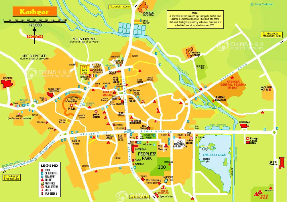
10. Map of Kashi (Kashgar) just because I've always been weirdly fascinated by the place. Note the areas that were not surveyed due to the arrest of the surveyor.
http://www.china-tour.cn/images/Kashgar/Kashgar-Map.jpg

Tuesday, June 5, 2012

Look Up Quickly! - The Transit of Venus

This map, courtesy of the Transit of Venus site shows where you can see Venus make its transit across the sun. Unfortunately here in the northeastern USA we can't see anything because we haven't seen the sun in days. Even if you still can't see it you can follow it on Slooh. Look quickly - or you'll have to wait until December, 2117.


Thursday, June 3, 2010

Map of the Week-Google Conquers Space!

In addition to knowing everything about you Google now has the Earth, the Sky, the Moon and Mars - in map form. Like Google Maps, Google Sky gives you an interactive mosaic of the visible universe. The images come from various sources, details can be found on their about page.


The buttons on the upper right give you the option to see infrared and microwave views, as well as overlaying a "historical" map from 1792 drawn by Giovanni Maria Cassini. The view below covers the same area as the one above.


You can zoom, pan and click on things as well as selecting views, galaxies, planets and constellations from a gallery at the bottom of the page. Here is a view of the Crab Nebula.


In addition to the sky, you can also Google Moon and Google Mars.
Here is a view of the moon with imagery, charts and Apollo Landings overlaid.


Here is what the topographic chart option looks like.


Finally, here is an elevation image from Google Mars.