Showing posts with label germany. Show all posts

Wednesday, August 7, 2024

Summer Light Reading 2024

Here is another installment of what is becoming an annual summer tradition. Just like the light beach reading, here is some light map reading. Not much to comment about, just some maps and related items I like.

First of all since the Olympics are in Paris, a nice papercut map you can enjoy, or buy here.

A very colorful map from Wikimedia Commons showing the different sections of the Rhine River. As one reader pointed out it looks like a water quality map and probably is as river quality tends to get worse as more cities and farms downstream dump pollution into them.

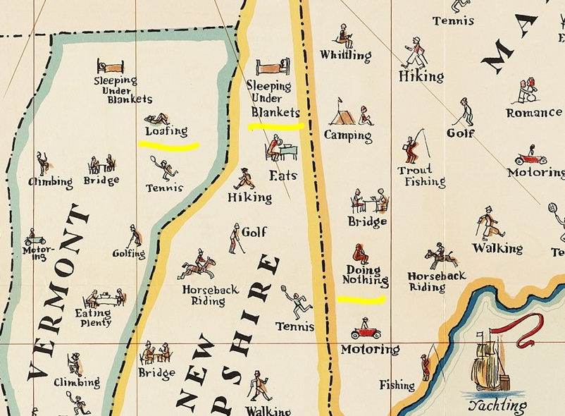
A map of things to do in New England. I copied a portion and highlighted some of my favorites such as "loafing", "sleeping under blankets" and "doing nothing".

Transit map of Kaohsiung on Taiwan. There are some great station names like Dream Mall, World Games and Oil Refinery Elementary School.

A screen shot from Yahoo Japan that I like for no specific reason.

Finally, Tsunami Generating Earthquakes. I think this originally came from some social media site that was once known as Twitter. Maybe from the U.S. Geological Survey.

OK, back to your beach read.

Wednesday, May 4, 2022

My Family's Exodus from Ukraine

A few weeks ago some of my family members had a Passover seder. Passover is an exodus story. With huge numbers trying to leave Ukraine right now our thoughts turned to my own family's exodus from there. Rising antisemitism, employment restrictions and forced military service drove my family to risk everything to escape from Khotyn, Ukraine (then part of Austria-Hungary) and come to the United States. My great grandfather was the first to leave, in 1905. He traveled by steamship from Hamburg, Germany to Philadelphia. How he got to Hamburg is less clear but the shipping companies arranged for passengers to travel there by train with minimal harassment. I made a map of the trip based on railroad maps of that era, making assumptions about the most likely route across Europe.

There was no railroad in Khotyn at the time so they would have needed to travel the 30 kilometers to Czernowicz (not Cherivsti), probably in secret. My great grandmother followed with several children two years later. It must have been very frightening to leave everything behind to go to a place where they didn't know the language or how safe they would be. I'm sure today's Ukrainians are going through similar or worse horrors. Here is a second, less interesting map I made to complete the journey.

There is a story about my great grandmother going grocery shopping on her first day and not recognizing the house on the way back because the houses in South Philadelphia all looked the same. She had to walk up and down the street a few times before a neighbor came and helped her. If you see a lost refugee, They might need your help!


Wednesday, September 23, 2020

Maps Hidden in Playing Cards

 In World War II The United States Playing Card Company designed cards for POW's in Germany with maps hidden between the paper layers. When soaked in water the cards could be peeled apart and prisoners could see secret escape routes. These "map decks" were closely guarded secrets and few survive, This one from a private collection may be the only surviving example - via Bicycle Cards.

There is a replica deck available on Amazon. The image gives a better idea of what they would have looked like.


Wednesday, August 28, 2019

The Battle for Germany, 1944

My wife found a treasure trove Life Magazines from the 1940's on the curb. The issue from 75 years ago today has some excellent maps showing the war situation.

In addition to this overall map are three maps showing greater details of the western, southern and eastern fronts.
A zoomed in view shows the slow movement of the line of Allied control in Normandy between June 6 and August 18th, 1944.
The Southern Front map shows the recent landings in southern France.
The simple and clearly readable topography is a nice touch. Here is the Eastern Front.
Here is a little detail with the August 18, 1944 battle line clearly shown.

Wednesday, June 26, 2019

Treaty of Versailles

This Friday, June 28th marks the 100th anniversary of the Treaty of Versailles. This treaty changed the borders of Europe, at a particular disadvantage to Germany. Here is a 1920 newspaper map "from book" via UCSB professor Harold Marcuse's web pages.
http://marcuse.faculty.history.ucsb.edu/classes/33d/projects/1920s/CarlosVersaillesMap650pxw.png
Another map, via Mark Callagher shows the German territorial losses much more clearly.
http://markcallagher.com/history/ww2readings/2_Treaty%20of%20Versailles/page_09.htm
In addition to the widely mentioned losses to Poland, France and Denmark there are more obscure enclaves that I was not aware of. These include Eupen-Malmedy, a German speaking region of eastern Belgium.
https://en.wikipedia.org/wiki/Eupen-Malmedy#/media/File:Eupen-MalmedyGrenzveränderungen.jpg
Map via Wikipedia
Within this region was the jointly administered area of Neutral Moresnet. This was a neutral sliver of land between Belgium (originally the Netherlands) and Prussia that both countries were interested in because of a valuable zinc mine. Treaties after Napoleon's empire left the area neutral pending a future agreement. The region, along with the rest of Eupen-Malmedy was awarded to Belgium after the Treaty of Versailles. The region is shown in white on the postcard below.
Postcard via Wikipedia

There was also the brief existence of the Free State of Bottleneck. This bottleneck shaped area was leftover when the French and American post World War I circular zones of control did not meet
By Ziegelbrenner -.Source: Ravenstein Radwanderkarte, 1923
This region was cut off from the rest of Germany and was declared as a microstate in January, 1919. It was abolished in 1923. The state had about 17,000 people and printed its own emergency money featuring a map of the area.
https://upload.wikimedia.org/wikipedia/commons/b/ba/Notgeldschein_Freistaat_Flaschenhals_01.JPG
Image via Wikipedia


Wednesday, April 24, 2019

Range of the German 80-Mile Gun

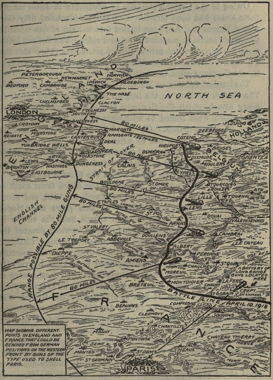
This map, via Project Gutenberg, shows the battle lines of April 10, 1918 and the areas of France and Britain that could be reached by the German guns that had been used used to shell Paris a few weeks previously.
https://www.gutenberg.org/files/34161/34161-h/images/img016.jpg
The map is from The Story of the Great War. This quote provides context.

"The Germans sprung a new form of frightfulness on the Allies when at 8 o'clock in the morning of March 23, 1918, they bombarded Paris with long-range guns. At intervals of about twenty minutes shells of 240 millimeters (about 9.5 inches) reached the capital, killing ten persons and wounding others. The shortest distance from Paris to the front was over sixty-two miles. The first daylight aeroplane raid followed this bombardment, but did little damage. Public interest was centered on the mysterious gun that could drop shells on the city from such a great distance. Pieces of shells examined were found to bear rifling marks showing that they had not been dropped, but were fired from some kind of gun. Later the French located several of these "mystery guns," and some were destroyed. The only purpose they could serve was to terrify the people of Paris, otherwise they were of no military importance."
Here's a zoomed in view to better appreciate the details.


Wednesday, April 10, 2019

La Jolla Map Museum - Maps of Historical Interest

Last month I visited the Map & Atlas Museum of La Jolla. They have an impressively large collection of original maps and many of them are of significant historical importance.

For example, here is one of the earliest recorded maps - baked onto a clay tablet.
Photo taken at the Map & Atlas Museum of La Jolla
It shows a parcel of land with ownership and dimensions in cuneiform. On the back are field measurements. This could be a legal document or may have been used as a teaching tool for surveying.

Here is a world map by Antonio Floriano (ca. 1555) using polar projections from the north and south poles. I took most of the following pictures on a phone so try to ignore the glare and reflections. Where possible I will provide links to better images online.

Photos taken at the Map & Atlas Museum of La Jolla

Each hemisphere is divided into 36 globe gores and therefore it was likely to have been designed for making globes. A better image can be found at The Vintage Map Shop. Here is some detail from the eastern Mediterranean.

A very different world map from a similar era (1581) is Heinrich Bünting's World Map.
Photo taken at the Map & Atlas Museum of La Jolla
This is a figurative map meant to represent biblical geography with the cloverleaf shape possibly reflecting the Trinity. A colored version can be seen here.

Leo Belgicus maps.
https://en.wikipedia.org/wiki/Leo_Belgicus#/media/File:1748_Leo_Schenk.jpg
An example of a Leo Belgicus via Wikipedia
These maps represent the "Low Countries" of the Netherlands, Belgium and Luxembourg as a lion, partially because the most of the provinces of these countries featured lions on their coats of arms. I did not get a photo of the whole map so I used an online example above. I did, however get a nice detailed close up.
Photo taken at the Map & Atlas Museum of La Jolla
I love the way the Rhine and Meuse Rivers flow over the paw like blood vessels. The paw scratching at "Colln" (Cologne) is a nice touch.

Here is a detail from Map of the Caribbean (Spanish Main) by Peter Martyr, 1511. Martyr was a friend to Columbus and the other explorers of the era. This is the first printed map devoted to the Americas. Martyr was also the first to have used the concept of a "western hemisphere" though he was not sure whether the mainland areas of South America were attached to India or not. Derived from confidential Spanish sources, it was very accurate for the time and also may have landed him in some trouble. The same year, King Ferdinand outlawed giving maps to foreigners.
Photo taken at the Map & Atlas Museum of La Jolla
I love the exaggerated detail of the coastlines.

More to come in a future post - stay tuned!

Thursday, November 8, 2018

Armistice and Occupation Map of Germany

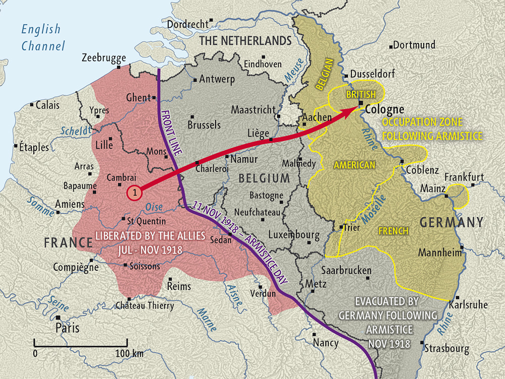
A hundred years ago the armistice was signed ending World War I. One of the more interesting maps showing the situation at the time is from New Zealand History.
https://nzhistory.govt.nz/files/styles/fullsize/public/occupation-of-germany-1000.jpg?itok=w3Evv33h
The front line on Armistice Day is shown in purple. The gray area to the east was evacuated by Germany after the Armistice was signed. Yellow areas are parts of Germany that were occupied by Allied Forces. Germany was given two weeks to evacuate the gray area and four weeks to withdraw their forces across the Rhine. Lands to the west of the Rhine were occupied as shown as well as three 30 km zones around the bridges at Cologne, Mainz and Koblenz. These areas were to be occupied for 15 years according to the Treaty of Versailles. However, the occupation was ended a little early,  in 1930.


Wednesday, September 28, 2016

Joan Blaeu's Remarkable World Atlas

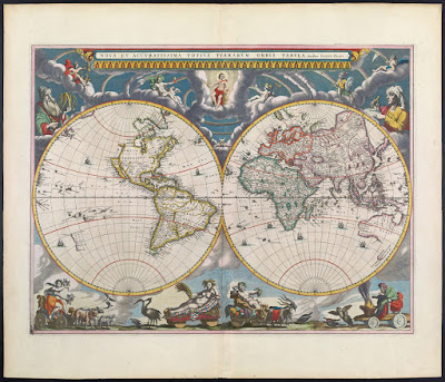
Joan Blaeu produced a remarkable 11 volume atlas between 1662 and 1665. It was the largest book published during the 17th Century. 
These volumes were meant to be the first part of a larger series. The title translates to "Grand Atlas or Blaeu's Cosmography, in which are most accurately described earth, sea, and heaven" with a second part about the oceans and a third about the stars. However, he did not live long enough to publish those volumes.

This summer I went to the Osher Map Library in Portland, Maine to see their Pictorial Maps exhibit (see my previous blog post for a review.)  The first map in the exhibit though not "American" or part of the "Golden Age" was from this atlas and meant to show an early use of pictorial decorations on maps.
http://oshermaps.org/map/458
While I was there, they let me look at a volume of this atlas. I chose the first volume and took pictures of various pages, including the map above (though the image from Osher shown above is much better than my photo.) It was an amazing experience to hold a volume of this atlas in my hands. Unfortunately between the lousy notes I took and my lack of knowledge of Latin, I don't have much to add to the photos I took - here they are.
From the Introduction - the orbit of the known planets, going out as far as Saturn.
The first volume is mostly focused on the Arctic regions. Above is the island of Spitsbergen, below is the adjacent island of Jan Mayen with some great (and probably very exaggerated) details.
More easily recognizable to most people, Iceland.
In addition to maps, the atlas has some great pictorial details including this Walrus illustration,
and whatever this totem is. If I could read Latin, I might be able to figure it out. Note: see comments for a good explanation.
There are also details of buildings and other public and religious spaces. Again, I don't know what we're looking at here.
UPDATE: Reader Ted Kottler has identified this as Tycho Brahe's observatory on the island of Hven (aka Ven), Sweden in the Oresund, the strait between Sweden and Denmark. 

I'll finish up with one more map. After much curiosity and digging around, I figured out that the map below is part of the Nordfriesland district in Schleswig-Holstein, northern Germany along the border with Denmark. I'm still not sure what the underwater streams are - some elaborate planned land reclamation, ocean drainage project?
Once again, I would like to thank the kind and helpful staff at the Osher Map Library for allowing me to see and hold this atlas. Though the pictorial map exhibit is over, there are still lots of great things to see there.

Thursday, December 31, 2015

A Few Nice Maps from 2015

There are lots of best maps of the year posts on other sites. You could spend hours looking at the Maps Mania 100 Best Maps of the Year - not a bad way to spend your time if you have it. I also highly recommend Cartonerd's favorite maps list. I am not nearly that ambitious, nor can I pretend to have seen every good map that has been made in the past year. Instead, I will show three maps that I never got a chance to post during the year. I really like these, but will make no claims about their "best"-ness.

The Magnificent Bears of Finland - Annukkah Makijarvi*
http://grrr.fi/annukka-makijarvi/bears-of-finland-map/
This is a deceptively simple looking density map showing the population of bears by area.** If you look closely though the areas are made of of bears. A great synthesis of art and cartography.
* I think this map may be a couple of years old by now but it made the rounds on the map sites this year. 
** Not completely sure what the areal unit used here, a sort of bear grid perhaps.

Longyearbyen and Environs - Norwegian Polar Institute.
http://www.npolar.no/en/services/maps/printed/3d-longyearbyen.html
This map shows an area of Svalbard, an Arctic island off Norway. It is another artistically beautiful map. The International Cartographic Association's Map of the Month for November, 2015. Here are two zoomed in details.

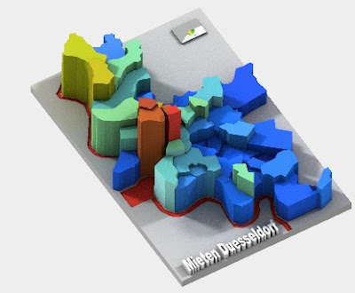
Sculpteo's 3-D Printed Maps

These "datasculptures" can be rotated in three dimensions, even in their preview views. They include several demographic maps, mostly from Germany. This example shows rents in Dusseldorf.
http://www.sculpteo.com/en/print/rent-level-duesseldorf-2012/Af3eGfhE?basket=1&noclickredirect=1&uuid=UZr77M6goy9bhc2drEzSRh

Looking forward to another year of mappy goodness!