Showing posts with label washington. Show all posts

Thursday, March 11, 2021

Art Maps-Elizabeth Person

This week is getting away from me so here is a quick post showing the map art of Elizabeth Person, based in northwest Washington.


There's a lot more to discover on her Etsy page.

Wednesday, July 1, 2020

Sea Level Rise-Coming to a City Near You

Conspiracy of Cartographers has a series of maps showing what will be underwater in various cities after 215 feet (66 meters) of sea level rise. Keep in mind that this is "end point" sea level rise and not anything we would see in our lifetimes. A recent page highlights new maps of Philadelphia,
https://conspiracyofcartographers.com/2019/10/12/philadelphia-sea-rise-map/
and Washington, DC.
https://conspiracyofcartographers.com/2019/10/12/washington-dc-sea-rise-map/
Both maps show similar patterns with the central cities completely flooded and the land being mostly peninsulas in the hilly north and western suburbs. There are also some nice puns.
In Philadelphia, Hunting Park becomes Fishing Park, University City becomes Irreversibly Pity, Wayne Junction, Drain Junction, and Northern Liberties is now Northern Fisheries.

Other maps have been done for cities in the U.S., Australia and England as well as a few larger regions. Here are Cascadia,
 The Palm Springs-Coachella area of California,
an almost completely waterlogged Brisbane,
and Los Angeles, featuring one of my favorite puns- the Ex-LAX airport.


Wednesday, March 7, 2018

The Dark Side of Drifters

Last week's tale of ocean drifters has an ominous side. In the past decade 14-18 feet (depending on the source) have washed up on beaches in British Columbia. Here's a detailed map with descriptions of the first 12 feet - via Global News
https://shawglobalnews.files.wordpress.com/2016/02/newmap.png
While this sounds like some sick amputation ritual and has inspired some dark literature, scientists say that it is natural for feet to separate from the body and that these deaths were not from foul play. The deaths are considered drownings or suicide. Most of these feet were wearing sneakers (or running shoes or athletic shoes or trainers, depending on the article and your regional term.) These shoes may have helped preserve the feet while other parts of the body have decomposed or possibly been eaten.

While there are probably bodies floating around most coastal areas, the unique geography and currents of the Salish Sea (including BC's Strait of Georgia and Washington's Puget Sound) have made these feet more likely to end up on the shore. Here's a map from the Sun (UK edition) showing the entire region.
https://www.thesun.co.uk/wp-content/uploads/2017/12/dd-composite-salish-sea.jpg?strip=all&quality=100&w=960
There's also a Wikipedia page about this phenomenon with its own (less dramatic) map.
https://upload.wikimedia.org/wikipedia/commons/6/69/Salish_feet.jpg


Wednesday, November 30, 2016

Under a Black Cloud!

https://www.loc.gov/resource/g4281p.ct000267/
This map is part of a paper addressed to the Republican National Convention of 1884. The purpose was to complain about the Northern Pacific Railroad holding title to "unearned" lands. These lands were granted to the railroad company for the purpose of constructing rail and telegraph links from Lake Superior to Puget Sound. The grants were made in 1869-70. By this date (1883) the company had only built a few small trunk lines, possibly just to keep their hold on the land in black above.

These lands were unavailable to homesteaders as long as the railroad held them. The company was accused of using stealth tactics to hang onto huge amounts of valuable coal and timber lands.
"The head of every true American should hang in shame that hair-splitting Congressmen have been found who, regardless of the duties of their office, have, at the command of their corporation masters, supported this contention by their arguments, their votes and their obstructive tactics."
The paper seeks a clear position of the party. "They do not want meaningless phrases or equivocal expressions, but earnest, honest words and work."
The map shows 40 and 50-mile limits from the proposed main and trunk lines in black as land unavailable to the public-"the crooked, tortuous and angular course of the railroad lines being only parallel by conduct of the Company itself."
Here is the edge of the "black cloud."

Wednesday, April 30, 2014

40 Maps That Won't Explain Anything - Part 2

Here's the second installment of 40 Maps That Won't Explain Anything - Part 1 with a snarky explanation about this series is here.

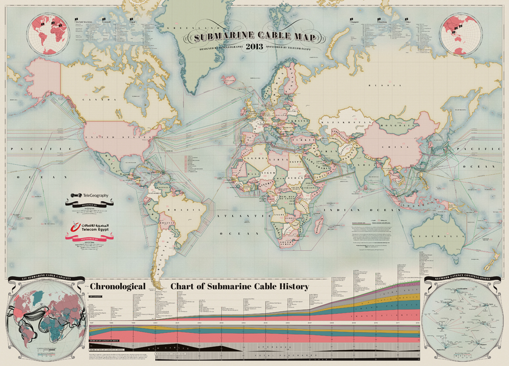
11. Hand painted map of submarine fiber optic cables. A zoomable version is here.
12. James Niehues makes pretty ski area maps. Here's Mt Alyeska in Alaska with the aurora borealis lighting up the sky.
13. Upside down 1963 Esso map for travelers going from New York to Florida.
http://imgur.com/RmpTTom
14. "Eastern Shore of Virginia - Most Fertile Trucking Area in the United States" G.L. Webster Canning Co.
http://www.lva.virginia.gov/public/archivesmonth/2005/vhs/VHS_8.htm

15. Map of San Seriffe - from a Guardian April fool's prank.
http://www.theguardian.com/news/datablog/2012/apr/01/guardian-april-fools-list#zoomed-picture
16. Majority Home Heating Fuel Type - Washington. From the American Community Survey.
17. TweetMap - heat map showing where people were tweeting using the hashtag #Phillies last summer.
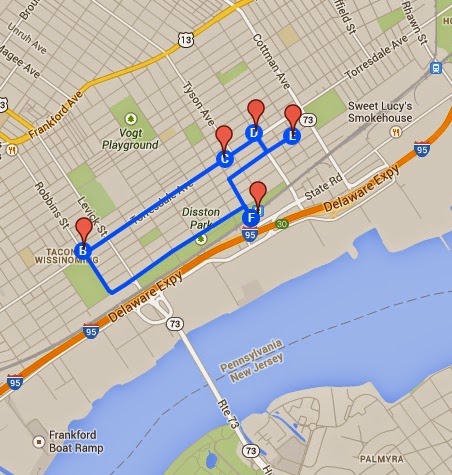
18. The Tacony Hoagie Trail in Northeast Philadelphia. Go for a healthy hike!
https://mapsengine.google.com/map/edit?mid=zhjjli_rr4GQ.kAhU8P0PgLN4
19. The Japan Railways System
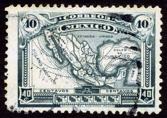
20. 1915 stamp featuring a map of Mexico


Wednesday, November 27, 2013

Wooden Bathymetry

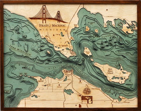
Below the Boat sells wooden charts made by laser cutting contour lines from bathymetric charts. They feature maps of various coastal areas and lakes such as Lake Tahoe,
http://www.belowtheboat.com/products/lake-tahoe
http://www.belowtheboat.com/products/san-juan-islands 
http://www.belowtheboat.com/products/straits-of-mackinac
http://www.belowtheboat.com/products/virgin-islands
and many more. Explore their gallery and you'll see lots of pictures of cute pets posing with their maps.

Thursday, July 25, 2013

Where Does That River Go?

If you're like me you look at a stream and wonder where it comes from or where it goes. The National Atlas has a new tool called Streamer. Click on a stream and you can trace it up or downstream. Here is the path of Butternut Creek in Charlotte, Michigan to Lake Michigan.
Tracing upstream is much more complicated. You get all the possible tributaries above you. Here's a trace of the Tennessee River near its mouth in Kentucky.
Unlike Streamer, rivers do not care about national boundaries. If you trace the Pend Oreille River downstream from Idaho, you get stuck at the Canadian border in Washington. The river itself only makes a short trip into Canada where it empties into the Columbia and heads right back into Washington but this is not shown in Streamer.
I like a good long windy path like the one made by Cassadaga Creek south of Buffalo. It starts just a few miles from Lake Erie but goes the other way instead.
Or Wyoming's Wind River.
Pick your favorite river (if you have one) and give it a try.

Wednesday, December 12, 2012

12/12/12

Happy 12/12/12!


 Here are some maps and boring facts about highways designated as Route 12 - mostly from Wikipedia.

US Interstate 12 is one of the shortest major (one or two digit) interstates in the country running 85 miles along the north shore of Lake Pontchartrain all in Louisiana. It is a shortcut that takes you from Interstate 10 back to Interstate 10 avoiding New Orleans. The road is also officially called the Republic of West Florida Parkway, in honor of that short lived republic created from an 1810 rebellion against Spanish rule.


By contrast US Route 12 is an almost cross country route running from Detroit to Aberdeen, Washington, almost 2,500 miles. The photo on the lower left was taken near the intersection of Michigan Avenue and Cass, where Route 12 officially begins. This photo came from the US Ends, a web site for people like me who are obsessed with where roads begin and end. On the left is a map of the Grays Harbor area at the western end of Route 12.


South Korea's Expressway Number 12 is also called the 88 Olympic Expressway. It runs across the southern part of the country.


There's many other highway 12's listed on Wikipedia's List of highways numbered 12 inlcuding the following three non-US routes chosen because I like their route shields.


Finally realizing that I forgot the awesome Kansas sunflower route shields (despite K-12 being retired,) here is another set of US state route shields. Once again, Happy 12/12/12!