Showing posts with label montreal. Show all posts

Wednesday, April 22, 2026

Ethnic Diversity of Toronto

 Jeff Allen is a cartographer based at the University of Toronto and does work for their School of Cities. He’s created some interesting visualizations, particularly around language. Here is a page where you can choose from dozens of languages to see how their speakers are distributed across the Toronto and Hamilton metropolitan areas.


Above I’ve chosen five languages represented in different colors. While French and Spanish speakers appear to follow overall population trends (no obvious clusters) there are very clear clusters for Mandarin, Punjabi and Italian.

I tried a few random smaller languages to see if they had their own clusters, which they do. Khmer and Lao speakers cluster in the same Jane Street area while Yiddish (and Hebrew also) cluster along Bathurst Street. 


Another visualization traces the history or ethnic groups. Choose from over 20 languages and you get a scrolling story showing the distribution changes at various time periods going back to 1971 .

Here is Yiddish, showing the same pattern as in the previous map.

Branching out to other cities this visualization shows the English-French east-west divide in Montreal. The purple areas are the most bilingual, while yellow areas are where immigrants live and are less likely to speak either language.


You can see many more of his maps here.

Back to Toronto, here is a gorgeous, colorful map by Alex McPhee showing the most commonly spoken non-English languages across the city. The “small multiple“ maps across the bottom, showing the top languages are a nice touch. 


He has produced similar maps for Montreal and Saskatoon.


I’ll close with one more Jeff Allen map: Dogs of Toronto.


Wednesday, October 24, 2018

The Quebec Election Cartogram

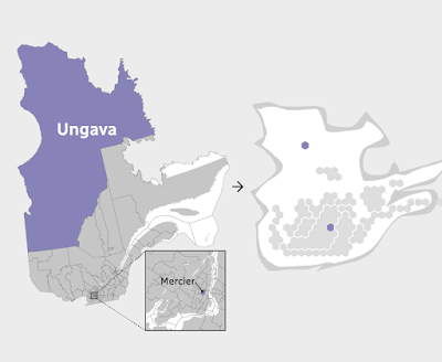
Quebec is a great use case for election cartograms. The map below (via CBC) shows how dominant the cities and suburbs are in population.
http://ici.radio-canada.ca/special/2018/elections-quebec/circonscriptions-resultats-cartes-vote-analyse-politique/
I like how they shaded the shape of the Province behind the hexagons. The geography be unrecognizable without it. The map at the bottom of their page illustrates how one Riding (district), Ungava covers over half of Quebec's area but contains a similar population to a tiny Riding in Montreal.
http://ici.radio-canada.ca/special/2018/elections-quebec/circonscriptions-resultats-cartes-vote-analyse-politique/
In the recent election the conservative Coalition avenir Quebec (CAQ) made huge gains at the expense of the Liberal and Québécois parties. Here are before and after maps. I rearranged the from the side by side view on CBC because the layout of this blog makes it easier to read this way.
Light blue is CAQ, dark blue Québécois red is Liberal and Orange is Québec Solidaire, another party that saw gains in this election. Above is before and below after the election.
Here is the side by side images as they appear on the CBC web page. The comparisons are easier to make when not distracted by the giant low density areas of northern Quebec.


Wednesday, April 10, 2013

Subways of North America

xkcd once again embraces their love of maps with Subways of North America. While I've seen similar subway map mashups, I've never seen them connected before.


These inter-city connections create some wonderful highlights. Here are some of my personal favorites:

The Cleveland Circle (Boston) to Cleveland shuttle - passing through West Trenton, this shuttle would be a nice easy way for me to leave work and go visit my Mom. West Trenton's location along Lake Erie just beyond South Harbor is also a bit curious.

The Green Line extension from Cambridge to Montreal - if it even makes it to Medford that would be remarkable.

The extension of the Market Street elevated subway line in West Philly/Upper Darby from 69th Street to Long Beach and LA.

The Rocky Mountain Tunnel (at sea level) connecting Chicago's O'Hare airport to Oakland.

A couple of extremely long subway tunnels from Atlanta and Miami to Mexico City.

The Puerto Rico submarine from Staten Island to San Juan and the connection from Jamaica (Queens) to Jamaica.

The Springfield Monorail connecting to nowhere, not even North Haverbrook.

There's lots of other things to explore including tunnels in the Caribbean,  "covertly repurposed" Amtrak lines, strangely renamed Red Line stations in Quincy, Mass. and a graveyard for passengers killed by closing doors - have fun exploring!

Wednesday, May 2, 2012

Canadians Are Not Themselves Today

Partners for Mental Health, a Canadian charity has introduced the Not Myself Today campaign. They want to get Canadians to sign a pledge of support for mental health and encourage them to talk openly about it. Part of the campaign is a crowd sourced mood map.


Each town or city is color coded by the the most predominant mood. When I first grabbed this screen shot Montreal was a nice calm blue though a large percentage of the respondents were also anxious or confused. Today the mood seems to have soured a bit, perhaps because of the gloomy weather? Montreal is anxious, Laval is irritated, St. Jean Sur Richelieu is confused, Mirabel is completely depressed while St. Jerome is sad, depressed and empty. On the bright side Pointe Claire is okay and Chateauguay is hopeful.

White means happy. Unfortunately there's not a lot of white but Pembroke's doing OK and Woodlawn is mostly happy though a bit stressed.


I assume the circle size represents the number of responses but they don't actually say that. It would be interesting to see if the moods correlate with weather but today is not a good day for that as it seems the entire country is cloudy. Hopefully this mapping project will help people feel better about themselves. Try to have a Selkirk, Manitoba kind of day!


Wednesday, February 1, 2012

Maps from Memory

Illustrator Ellis Nadler started a group on flickr for maps drawn From Memory. There's a nice variety of artistry and accuracy here. One of the better ones is Montreal de memoire from Axel Drainville.


User 4ojos has some very nice maps on flickr. Here's Goa.

 
For some enjoyable inaccuracy here is the Nadler's Brazil featuring Rio on the wrong side of the Amazon and in the wrong hemisphere.

Brazil map from memory

His Australia's a little off too...

australia map from memory

...but not as bad as the one drawn by his "highly educated" friend.

Australia map from memory

Nadler simplifies London in case you get lost.
Map from memory

Here's his solar system in case you get lost there.
Map of solar system from memory

There's many more fun maps on this group so go waste some quality time! 

Friday, January 27, 2012

Indoor Living - Part 2

Commenter Matt pointed out that Toronto has an impressive network of (mostly underground) connections. In fact it is the largest underground shopping complex with 28 kilometers (17 miles) of shopping arcades. Other interesting facts about the network can be found here. Below is a map of the system from ygraph.


Montreal also has a large Underground City represented pink lines on this map.


Here is the Centre Eaton map.


Wikipedia has a comprehensive list of the world's major skyway and underground systems.

Wednesday, May 27, 2009

The Montreal Bike Fest

Bike month concludes with the Montreal Bike Fest, a week long celebration and North America's largest bicycling event. The festival involves several rides, a week of commuting activities, and related events. I have been to the festival several times and plan to be there again this year.

This Saturday things kick off with the Metropolitan Challenge, a 75-150 kilometer ride through the nearby countryside. I did the 100K ride a few years ago and it was lots of fun and not as difficult as it sounds. The following weekend has a Friday night ride and another one Sunday afternoon. These rides involve closing the roads to motor vehicles allowing cyclists to take over the streets. The Friday night ride (Tour la Nuit) draws approximately 12,000 enthusiastic riders, many in costume and with creative bike light displays. The Sunday ride (Tour de l'Ile) gets at least 30,000 and has had up to 45,000 riders. The 52K course (below) covers much of the city and is a great way to see neighborhoods you may not otherwise get to.

The route changes every year. This year they head west. There's usually crowds of enthusiastic spectators urging you on and in past years they have had a house decorating contest for residents along the route. 52K may sound long but my wife who's not a cycling nutcase like I am has done it several times and I bet you can too!

While in town I hope to get a chance to explore the Bixi. Montreal's new bike sharing program. Modeled after the Paris Velib system, it should look familiar to frequent readers of these pages. Here is a part of the Bixi system.


I hope I've inspired you to come up to Montreal or to at least dig your bicycle out of storage. Have a great end to your bike month!

Thursday, July 6, 2006

MOTW #34

This is a map outlining the places I rode my bike during my May-June bicycling vacation in Quebec. I went up there for the Montreal Bike Festival and did a bunch of other rides in the Laurentians.