Showing posts with label where I am right now. Show all posts

Wednesday, August 29, 2018

Aerosol Earth

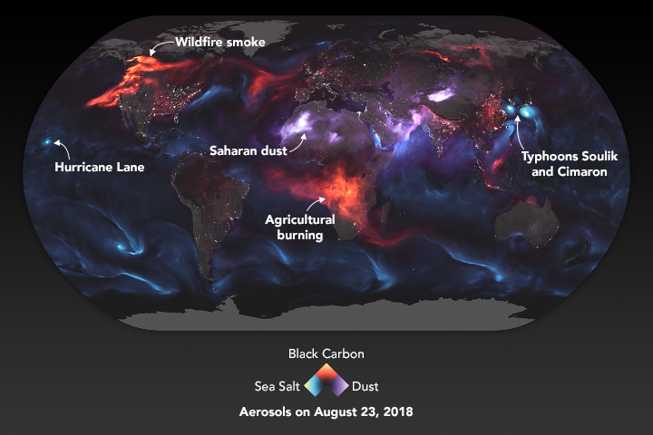
NASA's Earth Observatory created this stunning image of aerosols - airborne particles and liquid droplets.
https://eoimages.gsfc.nasa.gov/images/imagerecords/92000/92654/atmosphere_geo5_2018235.png
These aerosols "range in size from a few nanometers—less than the width of the smallest viruses—to several several tens of micrometers—about the diameter of human hair. Despite their small size, they have major impacts on our climate and our health." - via NASA aerosol page

In the image above blue represents sea salt. The concentrated areas show major storms, particularly two cyclones off the coasts of Japan and Korea and a hurricane approaching Hawaii. Red indicates black carbon, mostly from agricultural burning in Africa and Wildfires. Purple is dust, mostly from deserts. Also included is a layer of white night light data to indicate urban areas. Here is the legend enlarged for emphasis.
The NASA page includes a zoomed in detail from southern Asia, emphasizing the deserts, cyclones and population centers of the area.
More from NASA here.

Wednesday, May 23, 2018

This Map of Iceland Has it All!

This map of Iceland*, part of the Theatrum Orbis Terrarum** by Flemish cartographer Abraham Ortelius has all kinds of interesting stuff going on.
https://myndir.islandskort.is/map/Kortgerd_Abrahams_Orteliusar_10/Islandia_30/650/2012-04-25-09-29-38.jpg
From wonderfully detailed volcanoes,
to fantastic sea creatures with descriptions in the text keyed to letters.
This description is from a listing on Barry Lawrence Ruderman Antique Maps. Some versions of this map have the letters next to them and some do not.
H. The largest kind of Whale, which seldom shows itself. It is more like a small island than like a fish. It cannot follow or chase smaller fish because of its huge size and the weight of its body, yet it preys on many, which it catches by natural cunning and subtlety which it applies to get its food.
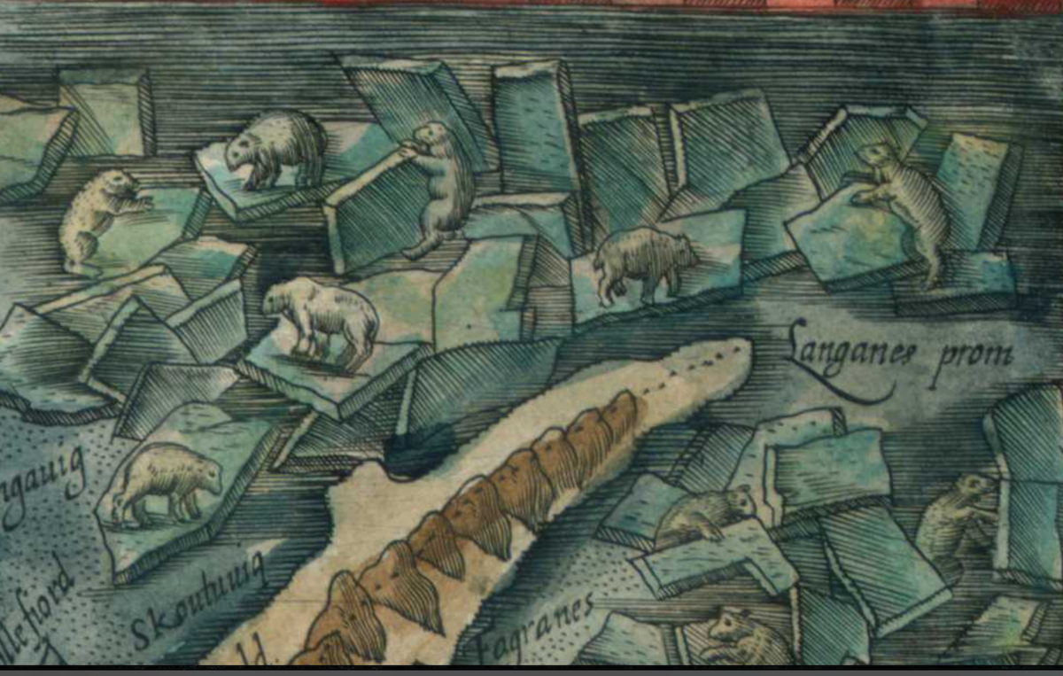
This map includes an early explanation of how polar bears arrived, drifting on sea ice.

In the right of this image are tree trunks that after some violent storms have been "torn off by their roots from the cliffs of Norway, tossed to and fro, and surviving many storms, finally cast upon and coming to rest at this shore."
The title block - differently colored in different versions.
In the lower right is a dedication to the "Illustrious and powerful Frederic the Second, King of the Danes, Norwegians, Slavs, Goths etc., his most merciful Majesty."
The level of detail of this map indicates that although it is credited to Ortelius it was probably drawn by an Icelander, most likely Gudbrandur Thorlaksson who mapped the island in the early 1600s. His list of churches and fjords was used and there is much local knowledge that is unlikely to have come from Ortelius.

There are several versions of the map online, the images above are from the following:

Barry Lawrence Ruderman Antique Maps - this page has the translations I used and some good historical context.

Islandskort

Wikimedia

*Where I am currently staying.
** "Theatre of the World" - considered to be the first modern world atlas.

Monday, July 18, 2016

Fantasy Map of Damariscotta (a real place)

I made this fantasy map of Damariscotta, Maine, where I've spent a week each summer for the last 17 years. This map was done for a tutorial on manipulating maps in Photoshop. It's not much and I could have done more to it but I'm on vacation!
I added a few viking ships and a longhouse at the last minute to give it a little life. Enjoy!

Monday, November 2, 2015

Mappa Monday: The Schuylkill River Aerial Tram

The 1976 Bicentennial celebrations prompted some grand visions for Philadelphia. Planning director Edmund Bacon envisioned a world's fair modeled on the highly successful 1876 Centennial, the first major world's fair in the United States. The fair was to be held on the same exhibition grounds as the 1876 fair with a system of boats and aerial trams along and across the river linking it to the central parts of the city.

http://philadelphiaencyclopedia.org/archive/bicentennial-1976/#6808
Utlimately this and other grand plans were sunk by the politics of the time. The bicentennial events did bring millions of tourists to the city but the numbers were well short of expectations, as were the long term benefits to the city.

Tuesday, June 17, 2014

Truckee River-Reno, Nevada

The Truckee River flows out of Lake Tahoe, eastward through Reno, emptying into Pyramid Lake. Similar to the Humboldt Sink, this lake does not have an outlet. Water evaporates or flows into the ground. Seems like a lot of water flowing by just to dead end in the desert.

The detailed map:
The schematic map:
The view:


Training through Nevada!

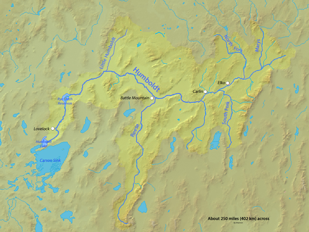
I have made it to Nevada! We are traveling along the Humboldt River which drains most of northern Nevada, but does not ever reach the ocean. The river drains into the Humboldt Sink, a dry lakebed. It forms a natural transportation corridor across the state and Amtrak's California Zephyr uses this valley to get across the state


Pass the salt!


Monday, June 16, 2014

Quest for Nevada Begins!

Train just pulling out of Denver. According to the Amtrak status map it's going to be a windy route.


Sunday, January 19, 2014

Live From Jerry's World

I am at the Brattleboro Museum in Vermont admiring Jerry's World, a fantasy map extravaganza that's been highlighted in a previous post.  

In Jerry's World voids threaten the urban areas,

fortunately some places are protected by a defense wall. 

A little history about a specific void is detailed in the text below.
Outside the main urban area things get wavier

At the far edges you might find beer and graham crackers.

Here's a whole wall of it. 

This map shows it all with the section shown here outlined in orange. The entire world (purple outline) is on exhibit at Summerhall in Edinburgh, Scotland until January 24th. This exhibit will be at the Brattleboro Museum until March 8th.


Saturday, January 4, 2014

Frankford Map Mural

The image in the header of this blog is a 1753 map of Philadelphia. On the far right is the Frankford neighborhood along "Franckfort" Creek . The Mural Arts Program has collaborated on a mural based on this map located nearby under the elevated SEPTA Market-Frankford Line. Here it is as I see it right now.
The view from snowy Womrath Park.

Wednesday, September 18, 2013

Waterplace Park, Providence

I am at the GIS-Pro conference in Providence, Rhode Island and don't have time for a real blog post so here is a "you are here" map. 


Sunday, July 21, 2013

A Bike Ride on Forbidden Drive and Beyond


It's been years since I've taken a ride down the Forbidden Drive and the Fairmount Park trails in Philadelphia. Today I got to relive the experience - riding from the suburbs to the center of the city with almost nothing but trees and water until you get near the art museum just outside of Center City. The maps are old and the photos taken on the fly are pretty lousy (except the one above from waymarking.com) but here they are.
This map was photographed (poorly) at the Strawberry Mansion Bridge. The Forbidden Drive is actually not shown and to the north of this map.
I like the diagrams of the bridges over the Schuylkill.

The best part is that they've now connected various parts of the Schuylkill paths so you can ride all the way to the center of town and beyond.


NOTE: I try to be spontaneous with these "where I am right now"posts but this one was edited quite a bit after the fact because cycling while blogging is a dangerous hobby.

Friday, July 19, 2013

At the Confluence

Here's a map of the confluence of the Chenango and Susquehanna Rivers at the confluence of the Chenango and Susquehanna Rivers. 


Thursday, November 22, 2012

A Thanksgiving Walk

I am walking the dog through Wynd's Woods - a name I didn't know before I saw the map.

Here's a close up of the map,


and a close up of the dog - pretending to be a good boy.

Happy Thanksgiving!