Showing posts with label japan. Show all posts

Wednesday, February 1, 2023

Suginami Walking Tours

Suginami is a ward on the west side of Tokyo. The Experience Suginami web page features a series of walks and tours with some nice maps. 

The Historical Walk shows not only the shrines and gardens of the neighborhood, but also shows where you can get ramen and "healthy" soy donuts. 

The Subculture Rock Walk shows the clubs, studios record and comic stores and other sites, as well as the nearby train stations.

The Smile-Pearl Walk takes you through the Asagaya neighborhood from the Smile Hotel to the Pearl Center.

This is extremely helpful because everyone needs a cup of smiling panda coffee.


Wednesday, December 8, 2021

Pearl Harbor

Pearl Harbor was attacked 80 years ago. Steve Walkowiak made a really nice map showing the Japanese first wave (red arrows) and second wave (purple) attacks. The damage to ships is shown as colored dots.

Click the image or this link to see the full map. The Japanese sent 353 planes in an attempt to cripple the United States Pacific Fleet. Here is a detail of the Battleship Row area.


Wednesday, October 7, 2020

Of Maps and Manhole Covers

One of my first posts featured this map on a Seattle Manhole cover. 

Since then I have been exposed to a world of manhole enthusiasts and found various other cool map examples. An entire blog post on this subject, complete with video can be found on Geography Realm.

Here is Oklahoma City, via Kontraband. The dot shows you where you are. There is a bonus state map at the top!

Chandigarh, India, a manhole possibly designed by Le Corbusier - via The Indian Express

Duluth, Minnesota with a dot pattern for Lake Superior- via flickr

Galicia - not a whole lot of detail here.

Over in Japan, colorful manhole covers are popular,

in fact so popular that there are sets of collectible cards. These cards have pictures as well as their gepographic coordinates so you can find them.

Here is a nice map, via guidable showing the locations of some of these cards. I'd like to be able to say more about this map but I don't know the language.

(Reference: Gesuido Koho Platform)

Wednesday, May 20, 2020

The Remarkable Maps of Mr. Tornado

Last night I watched "The Remarkable Mind of Mr. Tornado" on PBS. Tetsuya "Ted" Fujita was a pioneer in meteorology, known for developing the F-scale to measure tornadoes. His studies led him to draw many maps of this nature.
What I enjoyed the most was his personal maps. When he was invited to the University of Chicago to work with professor Horace Byers, he experienced his first airplane flight. During the flight he drew this charming map showing the clouds he passed through on a multi-day flight with two stopovers on Wake Island and in Hawaii.
https://www-tc.pbs.org/wgbh/americanexperience/media/filer_public_thumbnails/filer_public/f4/1d/f41d62b0-3130-42a8-a582-90c46092f80e/tornado-memoir_first-flight-mt0705m_ttu.jpg__1000x438_q85_crop_subsampling-2.jpg
Via PBS, "American Experience"
This map is a bit hard to read at this size so here is some detail. Click the picture above to see the entire map at higher resolution.
In his own words "Without wasting the expensive flight time, I began sketching the vertical time cross section of clouds along the flight path. Shortly before 1600 JST, the aircraft flew into towering cumuli, encountering severe turbulence. I heard crashing sounds of dishes and utensils in the flight kitchen. A moment after, the flight became smooth and I saw a beautiful arc of low clouds.”

After settling in Chicago he began to document his travel throughout the United States and Canada, first by railroad, then by car.
https://www-tc.pbs.org/wgbh/americanexperience/media/filer_public_thumbnails/filer_public/59/52/5952720f-777a-446f-af6e-ecffc9789e28/tornado-memoir_us-canada-mt0735m_ttu.jpg__1000x709_q85_crop_subsampling-2.jpg
He traveled through every state except Rhode Island. According to the map he only missed it by a few miles. I have chronicled my own travels in this manner but not with nearly as much charm or detail.

Highlights of this map include the tornado-chasing squiggles through Oklahoma and the green elevation contours.

More on Mr. Fujita here.
 

Wednesday, January 8, 2020

Rubber Terrain Map of Japan

Last week I was at the New York Public Library Map Room and asked to see this rubber terrain map that was featured on their Instagram page in 2018.
I was surprised that it was n fact available for public viewing and that they were willing to fetch it for me and even let me (very carefully) touch it. They brought it out in a huge box that took up almost half of one of their large tables.
Below is the magic that awaits when you open the box.
It caused quite a stir as many visitors in the room began circling the table for their own looks. Here are some close up pictures from my phone.
This map is dated January, 1945 and was created by the Office of Strategic Services (predecessor to the CIA)'s Topographic Models Section at the height of the war with Japan. According to The Mapmakers Craft: A History of Cartography at CIA, many models were made from plaster. I'm not sure why they chose rubber for this one or even how it was done-possibly melted into a plaster mold? I have not been able to find much information on this map. Here are some more topographic details.

The line from Otaru to Sapporo and on where Hokkaido suddenly gets flatter.
The Korean volcanic island Quelpart, now Jeju.
Mount Fuji.
Tokushima on Shikoku island with the Yoshino River valley making a deep cut in the land. This picture and the next one I took for another perspective on the Seto Inland Sea, featured in a recent post showing a 20 ft long scroll map that I saw at the Osher Map Library.
Finally, a look at the ancient capital Kyoto and the modern Osaka-Kobe metropolis.

Wednesday, November 13, 2019

Twenty Foot Japanese Scroll Map

This past summer I took a trip to the Osher Map Library. Among the many wonders I saw there was this 20 foot long scroll map of Japan's Seto Inland Sea.
This is what the map looks like rolled up.
Here are some close-up views. Some of the geography is difficult to reconcile with today's coast but the map appears to be looking westwards from Osaka Bay.
Details include mountains, shrines and navigation routes.


Here is a description of the map on the Osher web page.
"This Japanese scroll stretches over twenty feet, detailing the coasts and landscapes, castles, shrines and towns. Japanese maps tended to be much larger than European maps of the same era. Many of them were designed to be laid out on wooden floor mats. Created for the purpose of tracking economic activity by region, it notes the annual taxes for each community. It also notes Nagasaki as the only port available to Dutch and Chinese traders. This hand drawn map was crafted in the traditional, pictorial style, known during this period as ezu; the mountains, rolling hills, villages, fortresses, temples, are highly stylized."
The entire map can be browsed here. Here is a view of the entire map in one shot.
https://oshermaps.org/browse-maps?id=17833


Wednesday, July 17, 2019

Grab Bag

Here's a bunch of random maps. They won't "change the way you see the world" like so many other clickbait-y sites claim. They're just kind of interesting, or pretty, or something. Click on the map for the original source and higher resolution.

Meat Production on Ranches - via Pearson Education though I lost the link.
Tasmania's cartographic revenge - via Reddit
https://www.reddit.com/comments/auec0h

WestJet Destinations, 2000 featuring a Canada without Montreal or Toronto.
https://www.flickr.com/photos/erussell1984/45543438864

Proposed development of Toronto's industrial waterfront, 1910
https://static.torontopubliclibrary.ca/da/images/LC/maps-r-80.jpg
- via Toronto Public Library

Saloons, free theatre and "houses of ill fame" in Buffalo, 1893. If you're looking for this neighborhood, it's basically been torn down and replaced with expressways. Easy access from the Children's museum though.
https://imgur.com/a/7ZJ47DO

Geo-Eye (Mount Inasa), 2015 by Takahiro Iwasaki carved on a roll of vinyl electrical tape. Iwasaki is a Hiroshima-based artist. Mount Inasa is in Nagasaki.
https://www.artsy.net/artwork/takahiro-iwasaki-geo-eye-mt-dot-inasa
Where Europe and Asia would fit in North America climate-wise - via askthebirds
http://askthebirds.org/wp-content/uploads/2018/09/canada-physical-map-best-of-beautiful-nts-maps-canada-of-canada-physical-map.jpg
Tourism map - where to see whales, seabirds and icebergs in Newfoundland And Labrador - issuu.
https://issuu.com/newfoundlandlabradortourism/docs/whales_birds_bergs_map
Whales and dolphins in Costa Rica - via Enter Costa Rica
https://www.entercostarica.com/images/maps/map-whales-dolphins-flat-1000.png


Thursday, May 30, 2019

Japanese Control of Aboriginals in Taiwan

This map from the 1911 Government of Formosa Report on the Control of the Aborigines in Formosa shows the location of aboriginal tribes using vivid colors and language.
http://baxleystamps.com/litho/meiji/formosa_1911_rpt_map1-1.jpg
Japan took control of Formosa (Taiwan) in 1895 as a result of the First Sino-Japanese War. The Japanese were in a state of frequent conflict with the aboriginal people of the mountainous east, referred to as "savages" in the text as well as in the legend of the map. The map also shows "guard lines" - outposts manned by trusted indigenous troops under Japanese authority. 

The book details the customs of these people with extensive photographs. There were approximately 100,000 natives living in 671 villages.  It also includes two detailed topographic maps of eastern Formosa. Here is part of the northern map - click to see the entire map.
http://baxleystamps.com/litho/meiji/formosa_1911_rpt_map2-1.jpg
Japan held control of Taiwan up until the end of World War II, its resources and people contibuted greatly (though mostly not willingly) to Japan's rise as a global power.
 

Wednesday, June 6, 2018

The Evolving Japanese World View

Japan is known for a history of resistance to western contact and influence. As a result their knowledge of the rest of the world was slow to develop. The earliest "world" maps produced in Japan were Buddhist maps (nansenbushu) using a combination of geography and mythology.
https://www.tofugu.com/japan/japanese-cartophraphy/
The map above shows only China, Japan and India [source]. These maps were scaled by religious importance, rather than by distance so the geography is almost unrecognizable. India, the center of the Buddhist world takes up most of the map.

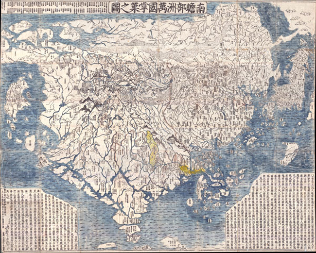
The first nansenbushu to show the entire world was a 1710 woodblock print by monk Rokashi Hotan.
https://files.tofugu.com/articles/japan/2011-04-07-japanese-cartophraphy/first-japanese-world-map.jpg
While still dominated by those three countries, this map shows various European countries as islands such as Holland (country of the red hair). Africa (Land of Western Women) and South America are shown as small islands while a piece of North America is connected to Asia by an Aleutian land bridge. By this time many western world maps had filtered into the country but these influences were either missed or were ignored by Hotan. Here is detailed look- the entire map can be browsed here.
https://www.geographicus.com/P/AntiqueMap/Nansenbushu-rokashihotan-1710
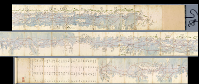
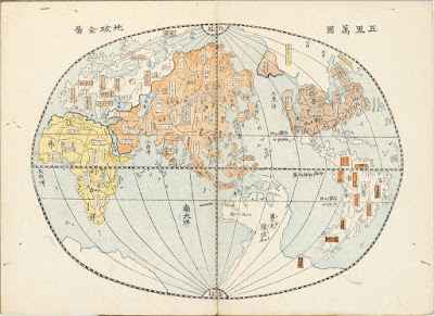
Matteo Ricci was a missionary who learned Chinese and made a map of the world in the Chinese language, readable to some Japanese. This influenced the Bankoku-sozu map, the first western style world map created in Japan. The version below is centered on Japan, oriented with east up and contains pictures of various ethnic groups.
The image above is a screen shot from The Evolution of Japanese Cartography by Olivia McCaffrey.
Nagakubo Sekisui, considered the founder of Japanese geography, made the above world map largely based on Ricci's map in 1785. Each continent has its own color while the unexplored Antarctica has a bold red outline. Here's a detail showing Japan (in the center of the world) and Korea.
Here is North America. California is shown as a peninsula because this map predates the theory of it being an island.
The entire map can be browsed at Barry Lawrence Ruderman Antique Maps, Inc, along with some interesting historical details. For example, Nagakubo's omitted ridiculous, prejudicial notes from the Ricci map about Japan while keeping similar notes about other places such as Brazil. "The inhabitants of this country do not build houses. They dig the earth and live in caverns. They like to eat human flesh, however they only eat men and not women. Their clothes are made from birds feathers."

An 1834 map by Giko Yamazaki drawn as a sphere - via the Ephemera Assemblyman blog - this page contains many other maps from this era. California has now gained its status as an island.
http://assemblyman-eph.blogspot.com/2009/07/japanese-historical-world-maps.html
Here is a map by an unknown cartographer via All That is Interesting from 1853, just when Japan was being forced to open itself up to foreign trade. The geography is improving noticeably.
Finally, a Japanese World Map circa 1933 by mangaka (cartoon artist) Keizo Shimada.
The "cultural vignettes" are mostly benign, if a bit stereotypical, but the map also gives a sense of Japan's imperial  and military ambitions. Some detailed views-via eBay.
Here is Washington and British Columbia.