Showing posts with label new hampshire. Show all posts

Wednesday, April 18, 2018

The Maps of Thoreau

Henry David Thoreau is mainly known for nature writing, but he was also an accomplished surveyor and cartographer. Here is a detail from an 1853 Concord, Massachusetts farm survey. Note the north arrows and the name of one of the abutting landowners "N. Hawthorne."
https://placesjournal.org/wp-content/uploads/2018/03/miller-9-thoreau.jpg
An excellent article by Daegan Miller in Places Journal (source of the image above) details his involvement in disputes between farmers and industrialists over the water levels of the Concord River. He carefully surveyed the river, noting depths, fords, sandbars and bridges with some interesting written embellishments such as "here is a shallow place", "quick current", "willow", "bottom soft", etc.

The article has a nice detail from a 91 inch wide rolled survey of the river. Unfortunately I cannot show it here because of permissions issues but you can see it from the web page of the Concord Free Library. One important takeaway is that through his notes on the map Thoreau sought to bring life to the map by filling details into the empty spaces. Previous maps had treated the river as a resource to be plundered. To quote Miller
"all those notes pinpointing where the plants grew, all those piles of figures and ghosts of surveys past, make of Thoreau’s a deep map — a view of an impressively interconnected world where nature, commerce, culture, history, and imagination all grow together — something nonfungible and specific: a full, a wild land living at once beyond and beneath the confined landscape of the town’s grasping improvers, both agricultural and industrial, who, despite their superficial differences, ultimately agreed that the best use of a river is to turn a profit."
Thoreau mapped many of the places he traveled to such as Cape Cod - via OpenCulture,
http://cdn8.openculture.com/wp-content/uploads/2013/10/HDT_Cape_Cod_large.jpg
and the Merrimack River in New Hampshire via Mapping Thoreau Country.
You can see a huge collection of his maps a surveys via the Concord Free Library's Thoreau Surveys page. Most are farm surveys from Massachusetts but there are also plans for industrial sites as well as copies of historic maps of North America.

Wednesday, August 10, 2016

Pictorial Maps-a more detailed review

Last week I visited the Osher Map Library where The Golden Age of American Pictorial Maps runs through September 3rd. I did a very short blog post. Now that I have more time here are some more detailed highlights. Most of the exhibit's maps can be seen and zoomed into online at this link. I took my own pictures to give a detailed look at parts of the maps and also to make the text more readable

The "Golden Age" of American pictorial maps is defined as the 1920's-1960's, a time when maps were part of and a reflection of the popular culture.  There are seven parts to the exhibit - I will try and show highlights from each in order.


1. Early Pictorial Maps
The first map in the collection is actually not from this time period - it is from a 1662 Joan Blaeu world atlas.  The point is to illustrate an early version of a map with many pictorial elements.

http://oshermaps.org/map/458
After touring the exhibit, I got a chance to hold a volume of this atlas in my hands. The atlas is full of great details that I hope to revisit in a future post.

George Walker & Co., Bird's Eye View from Summit Mt. Washington (ca. 1905)
http://oshermaps.org/map/40687
 This is a spectacular art/map combination. Here's a picture I took of the summit.

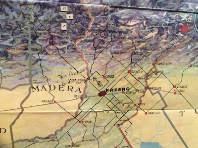
Fresno County and Mid-California's "Garden of the Sun" (author anonymous) is another one of my favorites:
http://oshermaps.org/map/4000155
Also in this section is the London Wonderground Map  that was the subject of a previous Map of the Week post.


2. Maps of Place and Region

Ilonka Karasz, Plan de Paris (1927)
http://oshermaps.org/map/4000160
Of course I love Paris but I also love the way the streets have hatch lines that make it look like they were stitched onto the map.

Carl Crow and V. V. Kovalsky Illustrated Historical Map of Shanghai (1935)
I liked the title block so I photographed it.
http://oshermaps.org/map/4000187

3. Maps to Instruct

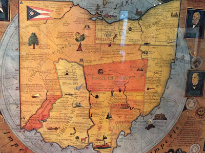
Arthur B. Suchy Ohio, Mother of Presidents (1939)
http://oshermaps.org/map/4000162
The regions are interesting and new to me-lots of good small details too.
Emma Bourne, America-A Nation of One People From Many Countries (1940)
http://oshermaps.org/map/4000182
This was published by the Council Against Intolerance in America to show how well immigrants have been integrated into society. "With the exception of the Indian all Americans or their forefathers came here from other countries." While I was at this exhibit, Donald Trump was across town trying to blame Maine's Somali immigrants for an imaginary rise in crime.

 Edward Everett Henry, The Virginian (1960)

a remarkably detailed map illustrating the first "western" novel.

4. Maps to Amuse
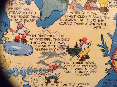
Ray Handy's Paul Bunyan map is some good, ridiculous fun.
http://oshermaps.org/map/4000166

Also, similar to my old Texan's map postcard is this Angeleno-centric "brag map"- proudly showing off local geographic ignorance. Chicago is a state but Wisconsin a mere city within Minnesota.  States are placed in ridiculous locations with a giant Iowa in the middle and phony places like "Feudville" in Kentucky.
http://oshermaps.org/map/4000146
5. Maps for Industry

Cleveland Terminal Group, The Capital of a New Trade Empire (1929)
Civic pride on steroids! I chose this one because my wife could find the intersection where she once lived on the map-it's right there in the lower right - see it?

Map of Michigan (Slightly Exaggerated) Shafer's Bakeries, Inc. (1949)
Similar to the LA "brag map" but also advertising bread ("such crust!") and using loaves as border decorations. Nice references to Florida as "Southern Michigan," California as "Western Michigan" and Chicago as the "Gateway to Michigan."

6. Maps for War.
 Ernest Dudley Chase, Japan, The Target: A Pictorial Jap Map (1943)
http://oshermaps.org/map/4000173
World War 2 in the North Sea Area...(1944)
http://oshermaps.org/map/4000171
This one was in a big glass display in the center of the room. As a result I was not able to get a picture without lots of reflections so use the link to see it better.

7. Maps for Postwar America.

There are lots of good maps in this collection, but I like this juxtaposition of an optimistic map of New York from 1958 followed by a gloomy view of LA from a decade later. The LA view features pink sky, smog and a sickly sun.

Nils Hansell, Wonders of New York (ca 1958)
http://oshermaps.org/map/4000176
Gene Holtan, Los Angeles (1968)
http://oshermaps.org/map/4000177
One final note: The staff at the Osher Library were extremely welcoming and helpful. Mr. Osher even dropped in to see what I was doing. I would like to thank them for all their help - and the lunch recommendation!

Thursday, February 13, 2014

The Incredible Journey of the Baby Hat

My wife knitted a gorgeous baby hat for our niece's little boy. She even hand dyed the yarn!
Unfortunately we had an incorrect zip code for her in Brooklyn. That sent it on a five state journey.
So far the hat has made two round trips between the Boston-Nashua vicinity and the Brooklyn-Long Island-New Jersey area with more to follow assuming it reaches its destination. The USPS Tracker below lists the destinations in reverse order.

Processed at USPS Origin Sort FacilityNASHUA, NH 03063February 12, 2014 4:41 pm
Processed at USPS Origin Sort FacilityBOSTON, MA 02205February 12, 2014 2:02 am
Arrive USPS Sort FacilityBROOKLYN, NY 11256February 10, 2014 7:38 am
Depart USPS Sort FacilityFLUSHING, NY 11351February 10, 2014 6:51 am
Depart USPS Sort FacilityFLUSHING, NY 11351February 10, 2014
Processed through USPS Sort FacilityFLUSHING, NY 11351February 10, 2014 5:33 am
Depart USPS Sort FacilityBOSTON, MA 02205February 8, 2014
Processed at USPS Origin Sort FacilityBOSTON, MA 02205February 8, 2014 5:54 pm
Depart USPS Sort FacilityKEARNY, NJ 07032February 7, 2014
Processed at USPS Origin Sort FacilityKEARNY, NJ 07032February 7, 2014 8:12 am
Undeliverable as AddressedBROOKLYN, NY 11223February 1, 2014 11:05 am
No Such NumberBROOKLYN, NY 11223February 1, 2014 11:05 am
Insufficient AddressBROOKLYN, NY 11223February 1, 2014 11:01 am
Arrival at Post OfficeBROOKLYN, NY 11223February 1, 2014 10:29 am
Processed through USPS Sort FacilityBETHPAGE, NY 11714January 30, 2014 1:58 pm
Depart USPS Sort FacilityNASHUA, NH 03063January 30, 2014
Processed at USPS Origin Sort FacilityNASHUA, NH 03063January 29, 2014 10:33 pm
Dispatched to Sort FacilityARLINGTON, MA 02476January 29, 2014 6:56 pm
AcceptanceARLINGTON, MA 02476January 29, 2014 2:17 pm