Showing posts with label denmark. Show all posts

Wednesday, September 18, 2019

Mapping the Nuclear Fear

I've lived in many different places in the United States and one thing that people in every place seem to have in common is the belief that their region is a primary nuclear target. I came across this map on a Reddit thread that I can no longer locate. The thread was full of anecdotes from all over the country of people being told that their town was one of the top targets of the Soviet Union back in the Cold War days.
The map is from the Federal Emergency Management Agency (FEMA) and dated September, 1990. Though I lost the thread, it was posted by Daniel Reetz. Here is the caption
Reddit is full of these kinds of maps and threads. Some of the maps are based on out of date information and show decommissioned sites. Here is a typical example of one of these maps showing two different scenarios - the black dots are mostly military installations while purple triangles are population centers. The comments are filled with people who are either proud to live in a targeted area or sad that their town isn't important enough to nuke. 
https://external-preview.redd.it/XRkc93B75o_newgXSZwdVV2Lwnkcnqvpc0wvmOowtu4.jpg?auto=webp&s=aed5129645baeadf7887451dbb9d69cf247a69f9
Here is another map focused on the military installations with the colors representing fallout areas.
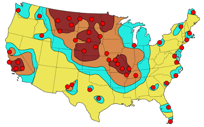
https://www.reddit.com/r/MapPorn/comments/1ym41m/femaestimated_primary_targets_for_soviet_icbms/
Here are evacuation routes for St Louis County via Reddit- this assumes an attack on downtown when there may be various other targets throughout the city and county.
https://external-preview.redd.it/FQoRGhom7-6tOP8YnQjScrRz-7JXidJ42YQkCH5ajQY.jpg?auto=webp&s=3164854ad6e731a9d8d7723b76312100405baa83
Of course, the United States was not the only place threatened. Here is a scary map of a 1970 Warsaw Pact plan for attack on northwestern Europe - highlighting the Copenhagen region of Denmark, via War is Boring.
Australia too-click for link.
https://antinuclear.net/2014/10/18/us-spy-facilities-at-pine-gap-and-nurrungar-are-targeted-by-russian-nuclear-missiles/
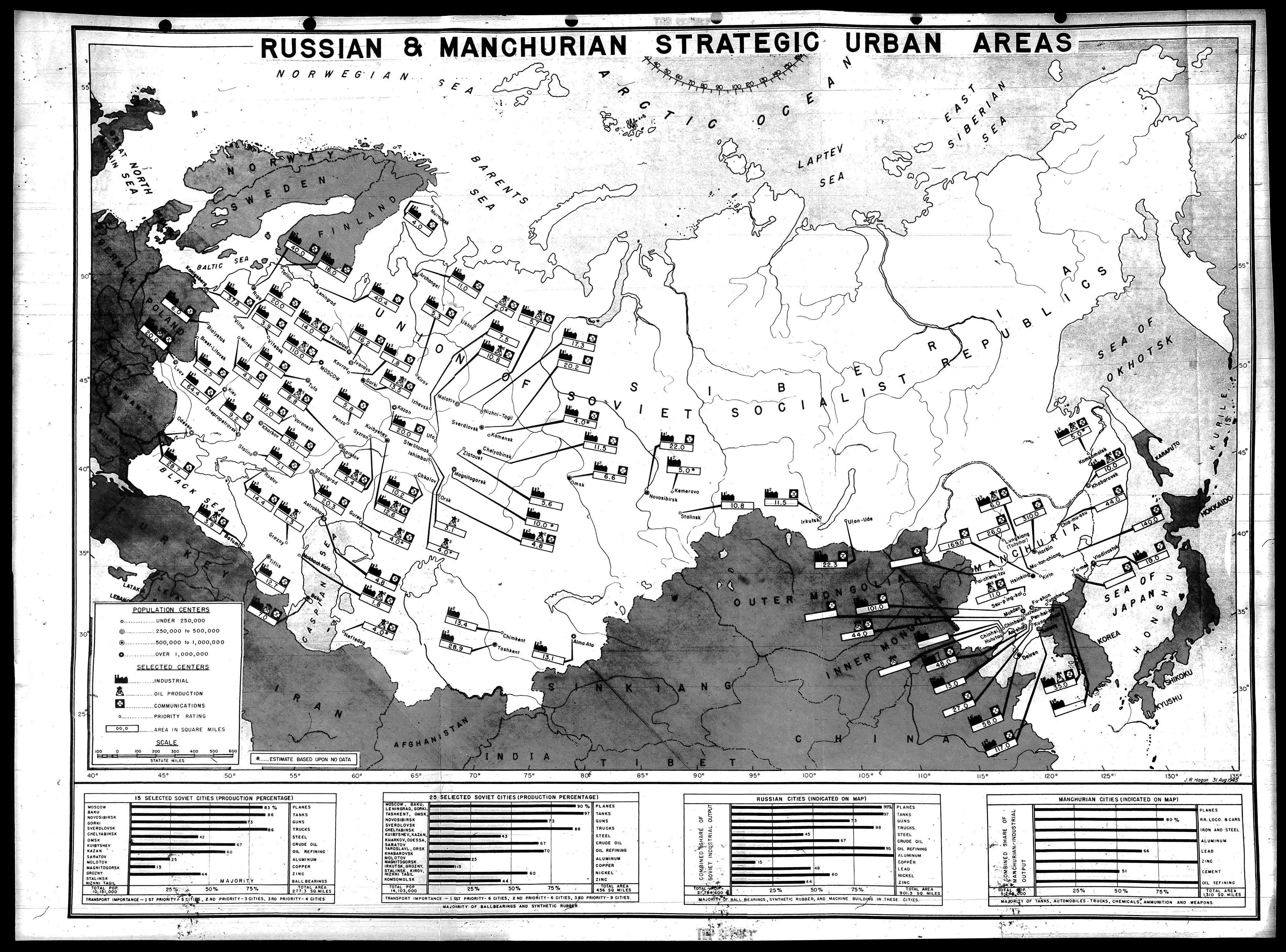
Here is a very detailed map of places in Russia (and Manchuria) targeted by the United States in 1945.
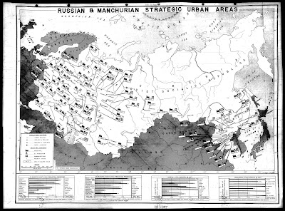
http://blog.nuclearsecrecy.com/wp-content/uploads/2012/05/1945-Russian-and-Manchurian-Strategic-Urban-Areas.jpg
This map is from the Nuclear Secrecy blog, a blog that also features Nukemap, where you can choose your bomb and location and see where the  extent of destruction. There are more recent maps showing the primary targets in Russia that I am not authorized to show (though you can Google them) - mostly production facilities for various metals and oil refineries.

Here is a communist propaganda map showing Russia encircled.
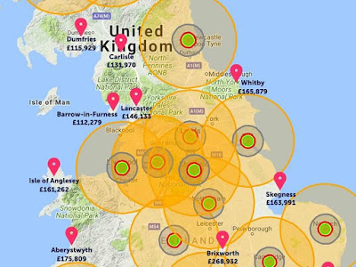
Finally here is a real estate agent's map of where it is safe to buy real estate in the event of an all out nuclear attack on the U.K.'s to 20 cities - via the Shropshire Star.
https://www.shropshirestar.com/news/viral-news/2017/08/11/an-estate-agent-has-drawn-up-a-map-showing-the-best-places-to-avoid-nuclear-fallout/
See you in Lancaster, or Aberystwyth.


Wednesday, September 28, 2016

Joan Blaeu's Remarkable World Atlas

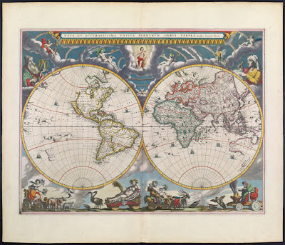
Joan Blaeu produced a remarkable 11 volume atlas between 1662 and 1665. It was the largest book published during the 17th Century. 
These volumes were meant to be the first part of a larger series. The title translates to "Grand Atlas or Blaeu's Cosmography, in which are most accurately described earth, sea, and heaven" with a second part about the oceans and a third about the stars. However, he did not live long enough to publish those volumes.

This summer I went to the Osher Map Library in Portland, Maine to see their Pictorial Maps exhibit (see my previous blog post for a review.)  The first map in the exhibit though not "American" or part of the "Golden Age" was from this atlas and meant to show an early use of pictorial decorations on maps.
http://oshermaps.org/map/458
While I was there, they let me look at a volume of this atlas. I chose the first volume and took pictures of various pages, including the map above (though the image from Osher shown above is much better than my photo.) It was an amazing experience to hold a volume of this atlas in my hands. Unfortunately between the lousy notes I took and my lack of knowledge of Latin, I don't have much to add to the photos I took - here they are.
From the Introduction - the orbit of the known planets, going out as far as Saturn.
The first volume is mostly focused on the Arctic regions. Above is the island of Spitsbergen, below is the adjacent island of Jan Mayen with some great (and probably very exaggerated) details.
More easily recognizable to most people, Iceland.
In addition to maps, the atlas has some great pictorial details including this Walrus illustration,
and whatever this totem is. If I could read Latin, I might be able to figure it out. Note: see comments for a good explanation.
There are also details of buildings and other public and religious spaces. Again, I don't know what we're looking at here.
UPDATE: Reader Ted Kottler has identified this as Tycho Brahe's observatory on the island of Hven (aka Ven), Sweden in the Oresund, the strait between Sweden and Denmark. 

I'll finish up with one more map. After much curiosity and digging around, I figured out that the map below is part of the Nordfriesland district in Schleswig-Holstein, northern Germany along the border with Denmark. I'm still not sure what the underwater streams are - some elaborate planned land reclamation, ocean drainage project?
Once again, I would like to thank the kind and helpful staff at the Osher Map Library for allowing me to see and hold this atlas. Though the pictorial map exhibit is over, there are still lots of great things to see there.

Wednesday, June 3, 2015

Beeswax Maps

Ren Ri is a Chinese artist and beekeeper. He uses beeswax as an artistic medium, creating sculptures and maps.
Above is "Indo-Malay Islands" from his "Geometric Series." Maps and other artworks were recently displayed in the PearlLam Galleries in Hong Kong. These images were taken from the exhibit's catalogue.
 "Korean Peninsula"

 "Mongolia"
 "Argentina" and "Scandinavian Peninsula"

"South Pole"
 "World"


Wednesday, August 17, 2011

Map of the Week - Reverse Colonialism

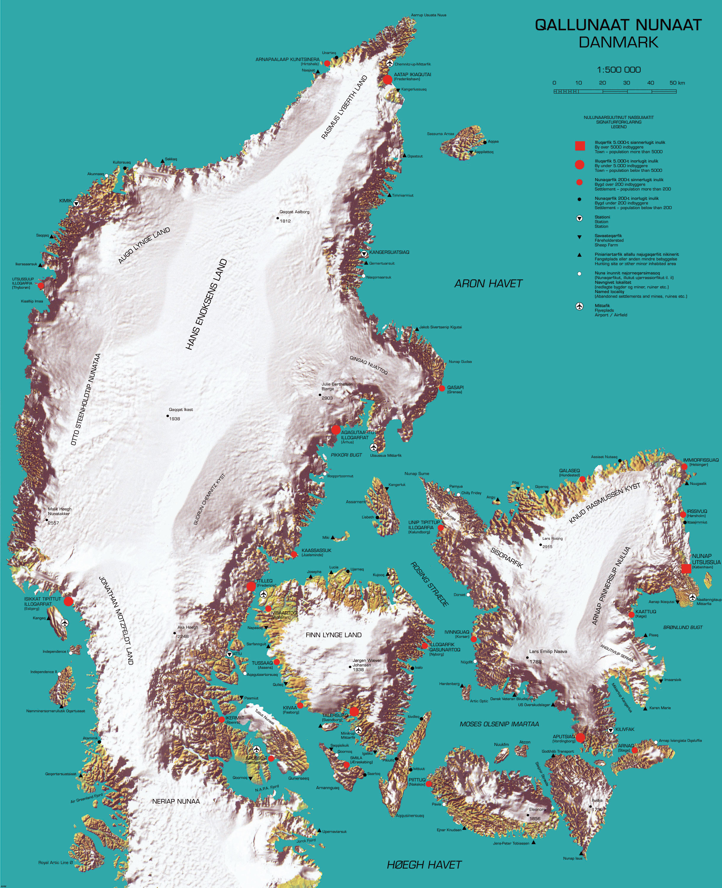
Here is a "cool" map that recently appeared on Strange Maps. It was produced by cinematographer and multimedia artist Inuk Silis Høegh for a project called "Melting Barricades," part of the  Rethinking Nordic Colonialism exhibit. The map pictures Denmark being colonized by Greenland, not just by the people but also by climate and topography.


Greenlandic names are imposed on places with the native Danish names in parentheses. The country name and title of the map is Qallunaat Nunaat (Danmark) and its largest city is Nunap Utsussua (København.) The coastline has become jagged from glacial erosion and the frozen interior named after native Greenlanders. The author also appears to have named a strait after himself, the Høegh Havet. 

There are a lot of details that escape me because I don't speak either of the languages and don't know my Illuqarfiks from my Nunaqarfiks. Some understandable (to English speakers) place names include "Chilly Friday" and "Air Greenland Fjord." 


Høegh also made a video called Attack-atigiit showing the Greenlandic occupation of Denmark. The language barrier prevents me from all the clever details but the general picture is clear. Below are some stills. The first one shows quizzical Danes studying the above map. At least I think that's the idea.


In this one Greenland is shown on a world map as a Mercator Giant, planting its flags around the world.


Wednesday, December 17, 2008

Map of the Week-Are You Happy?

This map shows "subjective well being" and is based on data from Eric Weiner's The Geography of Bliss. So maybe you thought Disney World was the happiest place on earth but you're wrong! It's Denmark!

I have not read this book so I don't know what all the criteria are but the caption references Happy Denmark's free education and health care as well as spending on the elderly and children. I agree that governments should spend on the elderly and children but am a bit skeptical that spending = happiness.


The map was produced by a geography student at
the University of Oregon and appeared in their alumni magazine. Thanks to Michael5000 for another great submission. Yes it only takes me 5-6 months to get reader's submissions out!

Friday, April 28, 2006

MOTW #27

This is really cool and useful too. A map showing where all the trains in Copenhagen are and tracking their movements. Warning - if you don't have java it won't work correctly and if you do you may have to wait a bit for the trains to appear.