Showing posts with label women. Show all posts

Wednesday, September 2, 2026

Guide to Running While Female in Phoenix

Described as a “an absurd guide to the regular wish-it-wasn’t-so paranoia of running as a woman in the city“, the Guide to Running While Female in Central Phoenix shows what to look out for along running routes in central Phoenix.


This map is produced by Steady Hand Maps. Jen Urso is an accidental cartographer, more of an artist who was asked to make a map. She has since made many very attractive hand drawn maps including the one above. The legend is simple, three symbols for where you can safely run in a sports bra (it gets extremely hot there), where you will get cat calls and places you should only run in the daytime.


Here is a zoomed in area. It gives some detail for those of us who don’t have to think about this stuff when going out in public.


Urso in her blog post begins with this quote; “I thought it was a funny and obvious map of my experience as a woman runner. The thing that shocked me the most was how shocking it ended up being…to men.“ She concludes with “My map, in its absurdity, points out that this is not and should not be normal or acceptable. We want to go outside, alone, and feel strong and capable. We just want to run.“

If you want to dig deeper, you can listen to her interview on the Phoenix NPR station or watch one on FOX-10.

For more maps by Jen Urso, you can browse through her map showcase here. Here is an example she did for a dance studio in St. Louis.


Wednesday, March 26, 2025

Karen Wynn Fonstad's Middle Earth Maps

I was not aware of Karen Wynn Fonstad until a recent article from the New York Times “Overlooked” series. Overlooked are obituaries about people whose deaths (in this case in 2005) were unreported in the Times. Fonstad created the Atlas of Middle Earth to accompany the works of J.R.R. Tolkien.

-via New York Times

She had become enchanted with Tolkien’s works. Having studied cartography and completed a Master’s degree in Geography, she pitched the idea of creating an atlas to Tolkien’s American publisher. While Tolkien and his son drew the original maps* Fonstad’s atlas represents a complete picture of Middle Earth during all of its ages and across all of Tolkien’s books. It discusses the geology behind land formations and includes city maps and floor plans or important buildings. Here is a detail of Frodo and Sam’s route to Mount Doom.

-via Wikipedia
 Her work was well received by Tolkien fans and scholars alike. To illustrate her impressive landscape details, here is the southern section of the Misty Mountains. They have a nice Swiss Topo look.

-from the American Geographical Society
*also note the illustrations of Pauline Baynes

Wednesday, March 30, 2022

Women's Suffrage in 1917

As a follow up to Women's Suffrage in 1908, here is an ad from 1917 showing how suffrage (the white areas*) had expanded through most of Canada and parts of the United States. 

The ad is from the National Women's Suffrage Publishing Company and asks how long the U.S. will lag behind Canada. For contrast here is the 1908 map again. Keep in mind that the color scheme is reversed.


*yes the white areas are actually sepia areas, OK.

Tuesday, March 8, 2022

Women's Suffrage in 1908

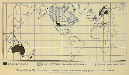
This map shows the international state of women's suffrage in 1908. It was originally published in Harper's Magazine and reprinted at ThoughtCo.

Full equal suffrage existed only in Australia, New Zealand, Norway, Finland and a handful of poorly drawn northwestern U.S. states. Finland also allowed women to run for Parliament. The "Municipal Suffrage" of Canada and Iceland meant women could only vote in local elections. The U.K. and Sweden vote in non-parliamentary elections.

This Wikipedia page gives more details. The page also mentions Latvia though not shown on the map. In many cases the right to vote was restricted for a time to married or property owning women. In Australia indigenous women were excluded from voting. It looks like Kansas is shaded in light gray though the Wikipedia page has that state granting women the right in 1912. Maybe it was being considered at the time. There was a gradual trickle of states between 1908 and 1920 when finally women were allowed to vote nationwide in the USA by the Nineteenth Amendment.

Wednesday, May 8, 2019

The Awakening

The Awakening, a cartoon by Henry Mayer about women's suffrage was published in 1915 in Puck Magazine. It shows liberty marching across the nation from the west to the east.
https://en.wikipedia.org/wiki/Puck_(magazine)#/media/File:Henry_Mayer,_The_Awakening,_1915_Cornell_CUL_PJM_1176_01_-_Restoration.jpg
The western states (in white) had all granted women the vote, while the rest of the country was "in the dark" waiting for the march of freedom, which finally came in 1919 with the 19th Amendment to the Constitution. Although New Jersey briefly allowed women the right to vote shortly after the founding of the country, it was the west where the right to vote was first permanently established. Wyoming was the first state to pass a law explicitly giving women the right to vote in 1869. Utah, Idaho and Colorado followed and by 1915 there was a clear geographical pattern.
https://en.wikipedia.org/wiki/Nineteenth_Amendment_to_the_United_States_Constitution#/media/File:Map_of_US_Suffrage,_1920.svg
The map above shows the state of women's suffrage laws just before adoption of the Amendment. The color scheme is complicated but dark blue is full suffrage and then the colors go through various levels of partial suffrage until red, which is no suffrage. The legend can be seen by clicking the image above.

The 19th Amendment passed the House of Representatives in May, 1919 and the Senate the following month. By August, 1920 enough states had ratified it to add it to the Constitution, however some  southern states did not ratify it for decades afterwards. Mississippi was the last state to ratify it - in 1984.

Wednesday, March 27, 2019

City of Women

A couple of years ago, Nonstop Metropolis: A New York City Atlas by Rebecca Solnit and Joshua Jelly-Schapiro, was published. In honor of Women's History Month here is one of the more interesting maps, titled City of Women. The authors renamed subway stations after women "by plotting the places where significant women have lived, worked, gone to school, danced, painted, wrote, and rebelled in order to come up with a feminist city.”
https://www.ucpress.edu/blog/wp-content/uploads/2016/12/CityofWomen_SolnitNMNY.png
“. . . names perpetuate the gendering of New York City. Almost every city is full of men’s names, names that are markers of who wielded power, who made history, who held fortunes, who was remembered; women are anonymous people who changed fathers’ for husbands’ names as they married, who lived in private and were comparatively forgot­ten, with few exceptions..."
Click above for details - here are some highlighted areas.
Upper Manhattan - a diverse mixture of women from all walks of life, including a Supreme Court Justice
 Brooklyn - many actresses and musicians, plus a Supreme Court Justice.
Flushing, Queens - site of the US Open. Tennis players, except for Hannah Feake Brown, a Quaker who probably was not a tennis player.
The Bronx - many women I am should be more familiar with, but are less known probably because of their minority statuses. Actors, musicians, political leaders - and a Supreme Court Justice.

Wednesday, March 8, 2017

Cartographic Gems from Women

I was a little hesitant to have a post on women cartographers. On one hand today is International Women's Day. On the other hand, with so many more women in cartography these days it seems kind of unfair to lump them all together as if they all think (and map) the same. On the other, other hand (3 hands?) I do not feature works by women here as often as I should.

In a previous post, I featured the Women in Cartography exhibit at the Norman Leventhal Map Center.  That post covered some major contributors to the field such as Marie Tharp as well as the history of somewhat anonymous women producing maps. For today I want to enjoy posting a few more recent maps.

Paranormal Madison by Chelsea Nestel
http://nestelmaps.azurewebsites.net/Content/images/C_Nestel_Haunted_I.jpg

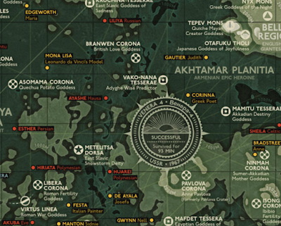
Goddesses of Venus by Eleanor Lutz - see my previous post for her Mars map.
http://tabletopwhale.com/2017/03/06/goddesses-of-venus.html
Shinjuku West by Geraldine Sarmiento
https://tangrams.github.io/tangram-frame/?url=https://raw.githubusercontent.com/tangrams/multiverse/gh-pages/styles/building-grid.yaml#16/35.6900/139.6920
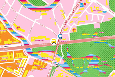
I also like her Candy Map style. Here is Candy Berlin.
http://geraldinesarmiento.com/candy-map/


Wednesday, January 27, 2016

Women in Cartography

Women in Cartography is an excellent exhibition at the Boston Public Library. It runs until March 27th. If you don't get a chance to visit in person you can view the exhibition online here. In December I got a chance to see it. Here are some of the highlights.

Physiographic Diagram of the Western Pacific Ocean - Marie Tharp and Bruce Heezen, 1971
Geologist/Cartographer Marie Tharp created the first map of the ocean floor. Originally this map was credited solely to Heezen, her research partner. It is displayed on the floor. Here is a picture I took looking down.
The numbers indicate depths of the sea bottom and height of undersea mountains. The colored areas are land, in this case the Hawaiian Islands rising from the depths of the Pacific.

Mappemonde Projetée sur l’Horizon d’Angers - Céleste Babin, 1839
This double hemisphere map was done by a student in Angers, France. The left hemisphere is centered on Angers and the right one on its antipode (opposite side of the earth.)
http://maps.bpl.org/id/19872
The detail below shows off some nice hand calligraphy and a view from Angers.
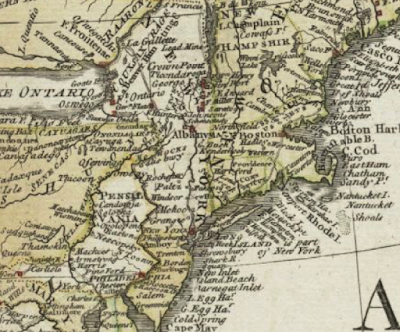
A General Map of North America …  - Mary Ann Rocque, 1761
Rocque carried on her husband's business after his death. This map was credited to "M.A. Rocque" obscuring (possibly intentionally) that it was produced by a woman.  
http://maps.bpl.org/id/12086

A New Map of ye Seat of War in Italy - Ann Lea and Robert Morden, 1701
Ann Lea also took over her husband's map business after his death. The map shows areas of northern Italy that were fought over between France and the Austrian Empire before Italian unification.
http://maps.bpl.org/id/15340

“Nationalities Map No. 1,” from Hull-House Maps and Papers … - Agnes Sinclair Holbrook, 1895
http://maps.bpl.org/id/19878
Hull House was a settlement house for female immigrants in Chicago. Holbrook, a house resident designed the map based on Charles Booth's income maps of London (previously mentioned in this post about my visit to Chicago's Newberry Library.) Other house residents helped her gather data for the neighborhood.
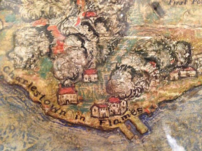
The Attack on Bunker Hill in the Peninsula of Charlestown the 17th of June 1775 - Mildred Giddings Burrage, 1926 
Burrage was a Maine-based artist. She created this map/scene using layers of Gesso to build up a sense of topography.
http://maps.bpl.org/id/19957

The exhibit concludes with a technology section including the following maps.

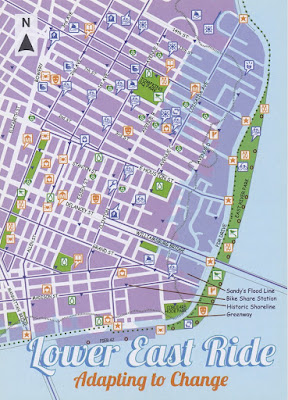
Lower East Ride: Adapting to Change - Maryam Khabazi, Designer, 2013
Created by Green Map NYC, this map highlights the impact of climate change and natural disasters such as Superstorm Sandy and shows resources to reduce energy consumption.
http://www.bpl.org/exhibitions/current-exhibitions/women-in-cartography/view-the-exhibition/women-in-cartography-33/


Making History - GIS and Women - Linda Loubert, PhD - 2014-
Dr. Loubert built this crowd-sourced webmap to document thousands of women working in the field of GIS.
http://arcg.is/1UE8onH
You can see the entire online map here or by clicking the image above. I know some of these people! GIS women rock!