Showing posts with label indiana. Show all posts

Wednesday, February 9, 2022

African American Homesteaders

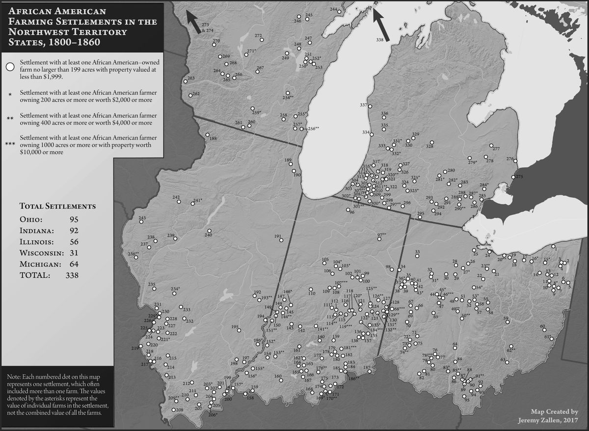
Homesteaders are widely thought of as white, but as this map shows there were a large number of black homesteads in the "northwest territories" in the early 1800s.

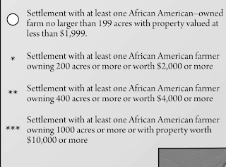
The map above is from The Bone and Sinew of the Land by Anna-Lisa Cox (image via Atlas Obscura). There are asterixes denoting the places where more valuable land was owned by African Americans. This is not a very clear way of quantifying data, but you can see it in the detail from southwestern Michigan.

Here is the legend.

What the map does clearly show are some interesting clusters of settlements in Michigan, Ohio and Indiana. By the late 1800's increasingly restrictive laws and resentment among nearby white settlers had driven many of these settlers away. Cox's book brings to light these forgotten settlements. 

A similar map appears in Free Black Communities and the Underground Railroad: The Geography of Resistance by Cheryl Janifer LaRoche. You can see it in the "Look Inside" feature on the Amazon link above. The cover is also adorned with some nice mappy details.


Tuesday, January 11, 2022

Redistricting Mini Golf

To show the absurdity of congressional district shapes, Dylan Moriarty and the Washington Post have designed this wonderful miniature golf game you can play online

Above is the Ohio 1st District. Republicans split Cincinnati into three districts to dilute that city's voting power. While not nearly the trickiest hole to play you have to squeeze the ball through the narrow gaps of Cincy.

The game begins in Wyoming, a state with only one district, therefore not one that can be manipulated. You can see from the layout that each district, or hole has an info box describing its demographics and voting patterns. 

The Illinois 4th District is famous for its "earmuff" shape, packing the Hispanic vote into the Midwest's only Hispanic-majority seat.

Indiana 7 is a trick hole. While the district looks very regular in shape, it is still designed in a highly political way by packing all of Indianapolis into it.

The toughest to play, by far is Maryland's terrible third. The water traps are completely unforgiving. 

You can see how I struggled with it by looking at my score sheet. Even with a generous par of 26, I was up to about my 50th stroke when I got caught in an impossible water situation and had to bail out.

Here is my final score sheet. I accidentally skipped the bonus hole-the original Gerry-mander in Massachusetts. This was my second go around so my scores on the other holes were pretty good. You have to play it at least once to get the hang of it. Have fun!

Wednesday, April 22, 2020

Maps of Televsion Places - Part 1 of ?

With much of the World's population under some sort of lockdown a lot of TV is being consumed. I was watching an old (they're all old) rerun (they're all reruns) of The Office the other night when I noticed this map on the wall.
https://auction.screenbid.com/view-auctions/catalog/id/105/lot/64031/
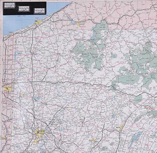
I had wondered about the frequent mention of these places - wait a minute, where's Stamford? Much more obvious is the giant Pennsylvania map in Michael's office. Both of these maps can be bought on Screenbid.
https://auction.screenbid.com/view-auctions/catalog/id/105/lot/64037/

https://auction.screenbid.com/view-auctions/catalog/id/105/lot/64037/
In past blog posts I have covered shows such as The Simpsons,
Bonanza,
and Batman.
These are just the ones I remember off the top of my head. There are probably more that I've covered over years of blogging. The world of television is full of maps of places both real and imaginary. One map the caught my attention a few years back but I never got around to featuring it. Here is Pawnee, Indiana from Parks & Recreation.
https://www.zmonline.com/media/16765487/ibn1uoxkhyorft0bng1_6ohucpxyhbx2dttvrzjdqkm.png
An article from New Zealand's zm shows how this map was taken from Christchurch.
https://www.zmonline.com/media/16765487/ibn1uoxkhyorft0bng1_6ohucpxyhbx2dttvrzjdqkm.png
 Here is the Land Use and Important Facilities Map of Pawnee.
https://i.pinimg.com/originals/16/85/a3/1685a34c43593e441aff2015765b4c36.jpg
Image stolen from Pinterest who stole it from Buzzfeed?
There are plenty more of these places to map (I could probably do an entire post on Westeros) and there will probably be future posts. Especially if we're all stuck inside for a couple more months.


Wednesday, February 25, 2015

A Trucker's Odyssey

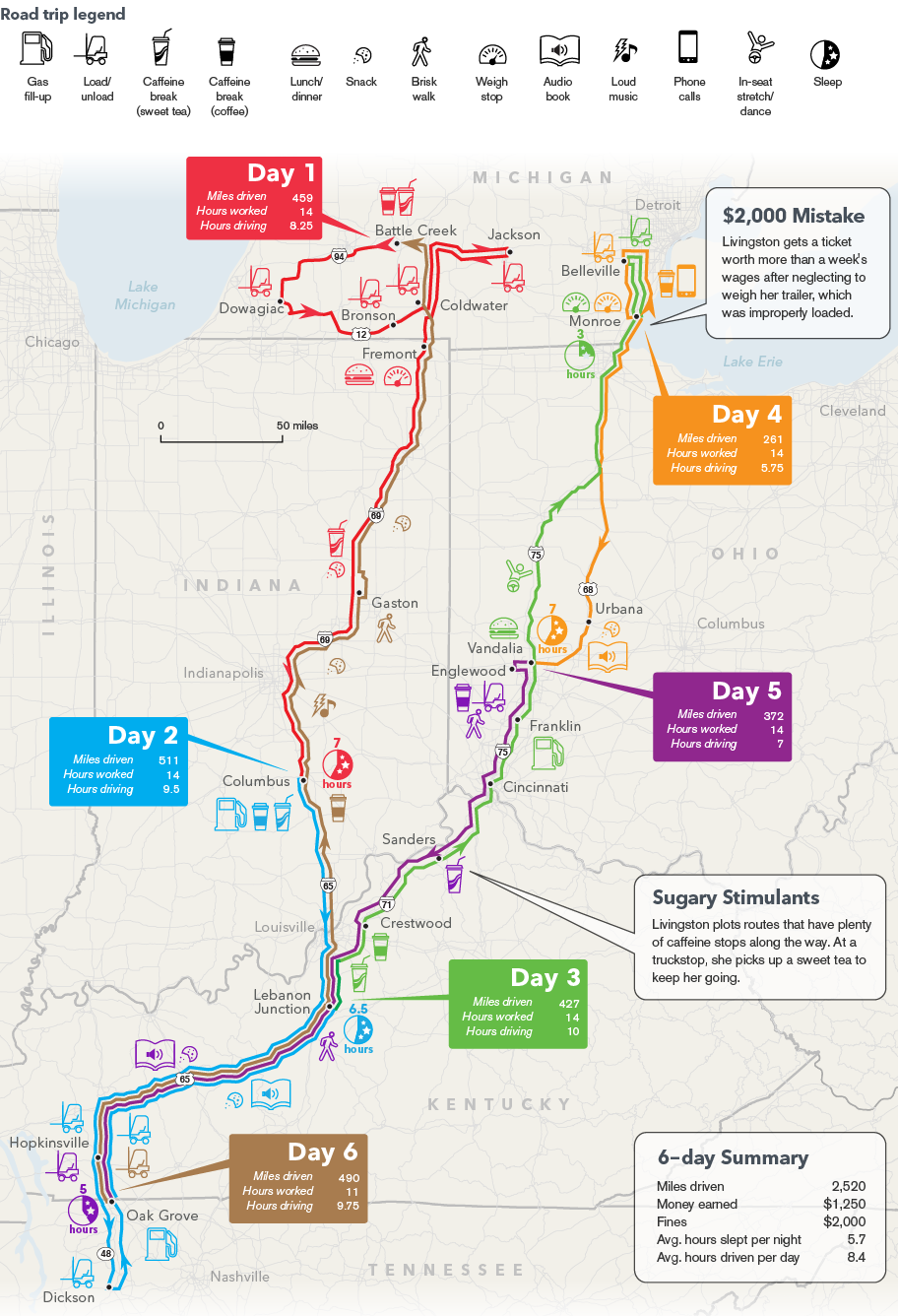
Bloomberg Business reporter Jennifer Oldham accompanied Tracy Livingston, a long-haul trucker on a six day journey involving two round trips between Michigan and Tennessee. The article provides a good, empathetic picture of the trucking life. They did an excellent job of mapping the journey.
http://www.bloomberg.com/infographics/2014-12-17/truckers-odyssey-six-days-on-the-road.html
You can click above for better resolution. Here is a detailed section.
The route is color coded by day. Icons are used to represent stops for gas, food, caffeine (a necessity when working 14 hour days) and various other needed diversions. These icons use the same colors for each day and add some personality to the map.

Wednesday, January 14, 2015

Big Ten Games of Thrones Map

Like many Americans, I spent way too much time Monday night watching the NCAA Championship football game. While not paying total attention, this commercial for the Big Ten Conference really jumped out at me. The commercial is called "Maps" and is based on the Game of Thrones intro (with the same music.)
It constructs a flyover of the US, starting at the Rose Bowl. As you pass by iconic buildings, stadiums and landmarks pop up from the landscape. Here is a tour using screen grabs from YouTube.

From the west coast you fly across the mountains to Nebraska, the current westernmost outpost of the conference.

Next comes Iowa, then Minnesota, then Wisconsin.
One of the most dramatic moments is watching the Chicago skyline pop up in front of the Northwestern logo. Note the theater references for Northwestern and Iowa. The mist coming off the Ohio River adds to the medieval theme.
The Michigan-Ohio State rivalry is about as big as it gets.
From there, it makes the jump to the east coast to cover the conference's recent acquisitions. Here are Penn State and Maryland with east coast icons such as the Capitol building, Washington Monument, LOVE statue and the Liberty Bell.
The flyover heads over the Atlantic and turns back to the west to include Rutgers the "birthplace of college football" (according to the ad) along with the NYC skyline and the ferris wheel at Seaside Heights, New Jersey. I like the reflections off the water.  
The full video is at the top - enjoy!