Showing posts with label fake places. Show all posts

Wednesday, March 26, 2025

Karen Wynn Fonstad's Middle Earth Maps

I was not aware of Karen Wynn Fonstad until a recent article from the New York Times “Overlooked” series. Overlooked are obituaries about people whose deaths (in this case in 2005) were unreported in the Times. Fonstad created the Atlas of Middle Earth to accompany the works of J.R.R. Tolkien.

-via New York Times

She had become enchanted with Tolkien’s works. Having studied cartography and completed a Master’s degree in Geography, she pitched the idea of creating an atlas to Tolkien’s American publisher. While Tolkien and his son drew the original maps* Fonstad’s atlas represents a complete picture of Middle Earth during all of its ages and across all of Tolkien’s books. It discusses the geology behind land formations and includes city maps and floor plans or important buildings. Here is a detail of Frodo and Sam’s route to Mount Doom.

-via Wikipedia
 Her work was well received by Tolkien fans and scholars alike. To illustrate her impressive landscape details, here is the southern section of the Misty Mountains. They have a nice Swiss Topo look.

-from the American Geographical Society
*also note the illustrations of Pauline Baynes

Wednesday, May 22, 2024

Middle Earth Transit Map

Hard to believe that those dumb hobbits risked their lives walking all the way to Mordor when they could have just taken the Orange Line. 

Oh wait, the tunnel under the mountain is closed 


so they would have had to switch to the Red Line at Bree and then made another transfer to get to Mount Doom. 

Still that seems like a minor inconvenience when compared to risking imprisonment by nasty spider. The Middle Earth Transit Map ("One does not simply walk") was created by Don Wilde Art. He also has a nice set of travel posters.

You can explore the map on Reddit.


Wednesday, March 23, 2022

The Atlas of Imagined Places

 The Atlas of Imagined Places by Matt Brown is now available.

The book shows the "likely geography" of places in literature, media, myths and video games.

"The authors have taken years to research the likely geography of thousands of popular culture locations that have become almost real to us. Sometimes these are easy to work out but other times a bit of detective work is needed and the authors have been those detectives. By looking at the maps, you’ll find that the revolution at Animal Farm happened next to Winnie the Pooh’s home."

Here is another image from the Amazon page.

Wednesday, December 23, 2020

The Springfield Subway

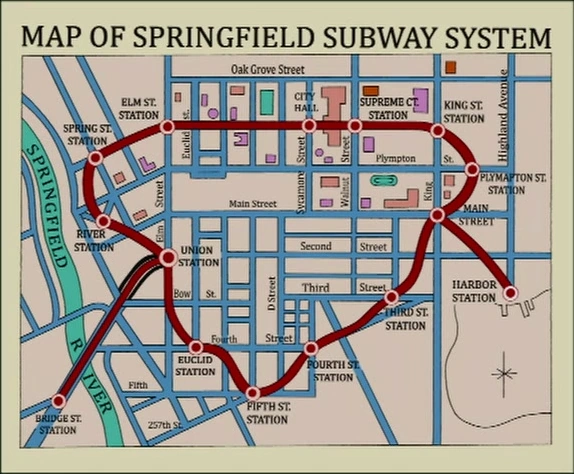
I recently saw the Simpsons episode Postcards from the Wedge for the first time. It prominently features this map of the abandoned Springfield Subway.

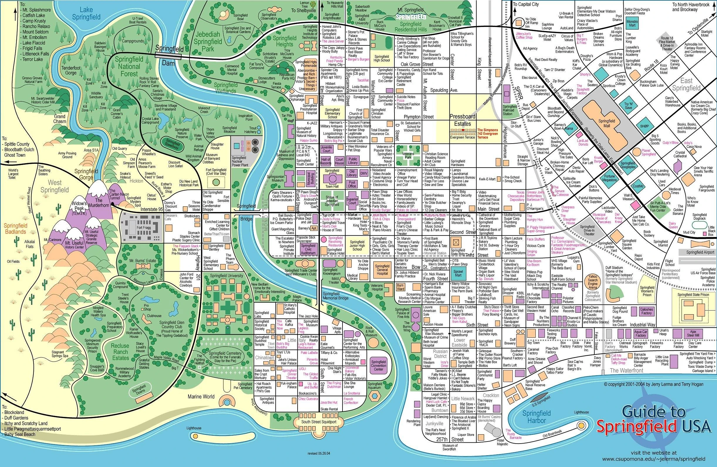
In a long ago post I featured the map of Springfield - a direct link to it is here

While these maps look very different a close look shows an unexpected attention to geographic detail. The street layouts are very similar between the two. The street names are also consistent. 

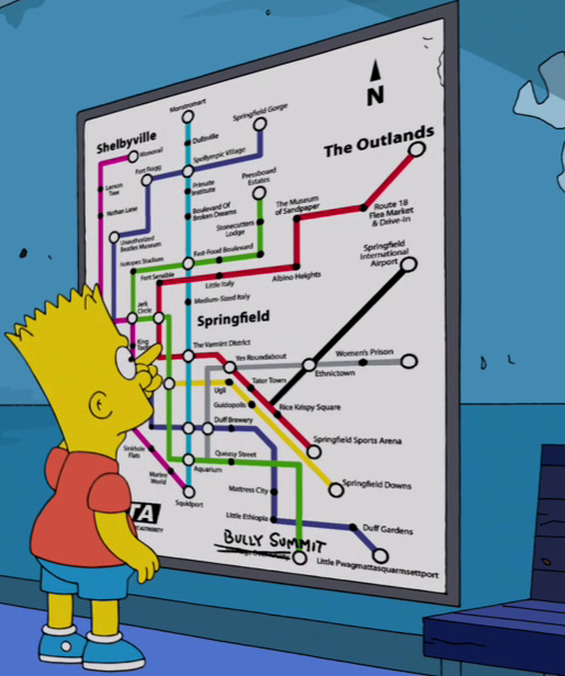
A newer version of the subway appears in a later episode with more jokes but less geographic fidelity. This version is full of puns such as the musical references Boulevard of Broken Dreams and Yes Roundabout. There's also Queasy Street and a Varmint District.

Springfield also famously had a monorail. I have not found any maps of it but here are the other towns that were sold on a monorail. This map is also available as a T-shirt.


Wednesday, September 16, 2020

The Maps of Pauline Baynes


Pauline Baynes was best known as a children's book illustrator. Her work on some of the most well known maps of the fantasy genre is less well known. She illustrated maps of Tolkien's Middle Earth and C.S. Lewis' Narnia.

Map of Narnia for Puffin Books U.K., 1972

After studying design at the Farnham School of Art, she started illustrating children's books. During World War II she joined the Women's Voluntary Service and eventually began making maps and nautical charts for the Royal Admiralty in Bath. This cartographic training served her well through her career. Her work was shown to J.R.R. Tolkien who was dissatisfied with his original illustrator for Farmer Giles of Ham. He was delighted with her work and hired her to illustrate the book.

Map for Farmer Giles of Ham-Pauline Baynes

Through Tolkien she got to know C.S. Lewis and was hired to illustrate and map his Chronicles of Narnia series.

1998 Narnia right book end sheet-via Peter Thorpe

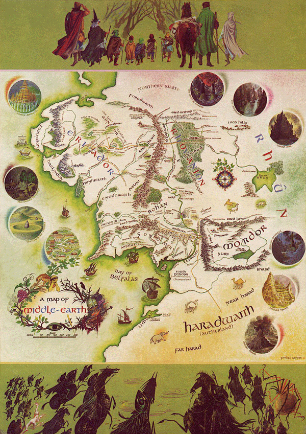
Baynes made a color map of Middle Earth published in 1970. Tolkien supplied her with various charts he made and annotated a map his son had produced for The Fellowship of the Ring in 1954. The annotated map was recently discovered inside Baynes' copy of the books. 


More details on this map can be found here. The finished product is below.

A little nice detail, including the cartouche.

To see more maps and artwork visit her tribute site.

Wednesday, April 22, 2020

Maps of Televsion Places - Part 1 of ?

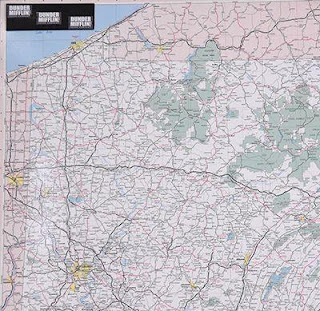
With much of the World's population under some sort of lockdown a lot of TV is being consumed. I was watching an old (they're all old) rerun (they're all reruns) of The Office the other night when I noticed this map on the wall.
https://auction.screenbid.com/view-auctions/catalog/id/105/lot/64031/
I had wondered about the frequent mention of these places - wait a minute, where's Stamford? Much more obvious is the giant Pennsylvania map in Michael's office. Both of these maps can be bought on Screenbid.
https://auction.screenbid.com/view-auctions/catalog/id/105/lot/64037/

https://auction.screenbid.com/view-auctions/catalog/id/105/lot/64037/
In past blog posts I have covered shows such as The Simpsons,
Bonanza,
and Batman.
These are just the ones I remember off the top of my head. There are probably more that I've covered over years of blogging. The world of television is full of maps of places both real and imaginary. One map the caught my attention a few years back but I never got around to featuring it. Here is Pawnee, Indiana from Parks & Recreation.
https://www.zmonline.com/media/16765487/ibn1uoxkhyorft0bng1_6ohucpxyhbx2dttvrzjdqkm.png
An article from New Zealand's zm shows how this map was taken from Christchurch.
https://www.zmonline.com/media/16765487/ibn1uoxkhyorft0bng1_6ohucpxyhbx2dttvrzjdqkm.png
 Here is the Land Use and Important Facilities Map of Pawnee.
https://i.pinimg.com/originals/16/85/a3/1685a34c43593e441aff2015765b4c36.jpg
Image stolen from Pinterest who stole it from Buzzfeed?
There are plenty more of these places to map (I could probably do an entire post on Westeros) and there will probably be future posts. Especially if we're all stuck inside for a couple more months.


Thursday, March 29, 2018

Landmarks: Maps as Literary Illustration

On Tuesday I got a chance to see an exhibit at Harvard University's Houghton Library called Landmarks: Maps as Literary Illustration. There was a great talk by illustrator and Cinemaps author Andrew DeGraff (whose own work is worthy of a future blog post) followed by a tour of the gallery. I hope to get back to share more before the exhibit closes (April 14th-soon!) but for now here are a couple of crude pictures I took with my phone. The description cards are mostly legible. Maybe I can get better pictures on a future visit.

Here are some Dell Mapbacks - more about Mapbacks here.
Finally, a Nancy Drew mystery.


Tuesday, February 20, 2018

The Changing Geography of Wakanda

Black Panther is a huge Hollywood hit set in the fictional country of Wakanda. The lead character has been through many iterations since his first appearance in Marvel Comics in 1966, as has his country. Wakanda is the most scientifically advanced country in the world. Isolation has enabled it to resist colonization and to develop its own independent technology. 

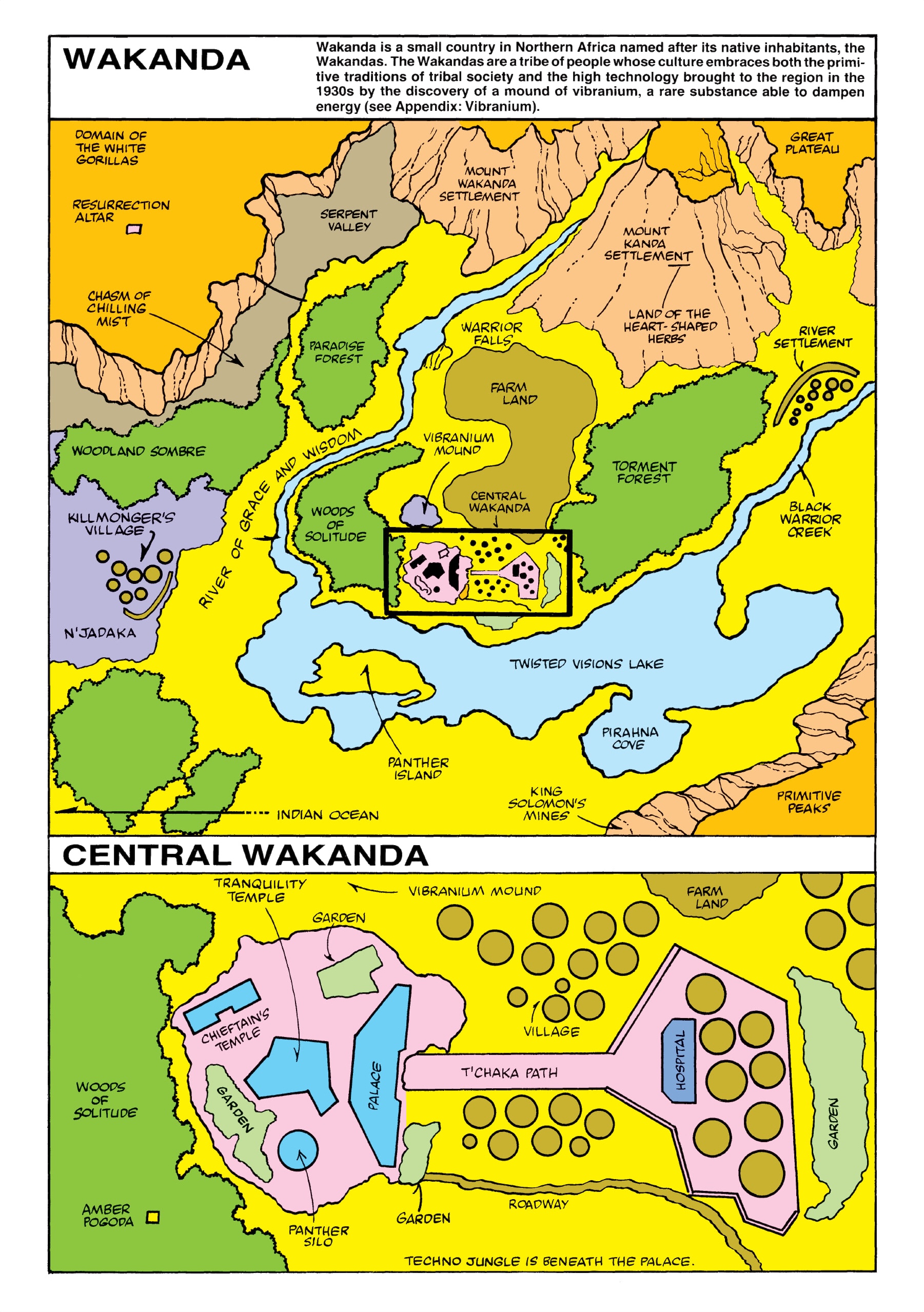
The first map, from Jungle Action Volume 2 #6, shows the Atlantic Ocean in the lower left placing Wakanda near the west coast of Africa.
https://vignette.wikia.nocookie.net/marveldatabase/images/3/33/Wakanda_from_Official_Handbook_of_the_Marvel_Universe_Vol_1_12.jpg/revision/latest?cb=20160509081608
A couple of episodes later the map was re-presented "with new details." The Atlantic Ocean was removed, probably to place Wakanda more in East Africa. Killmonger's Village is no longer a coastal settlement. There is an arrow in the bottom left of the map pointing to the Indian Ocean. There is speculation that they "flipped" the map (south is now up).
This became the definitive version of the map for decades. In 2008, Marvel published its Atlas of Fantastic Places giving a precise location of Wakanda and neighbors between Ethiopia and Kenya.
https://peterslarson.com/2016/05/14/the-fictional-nation-of-wakanda/
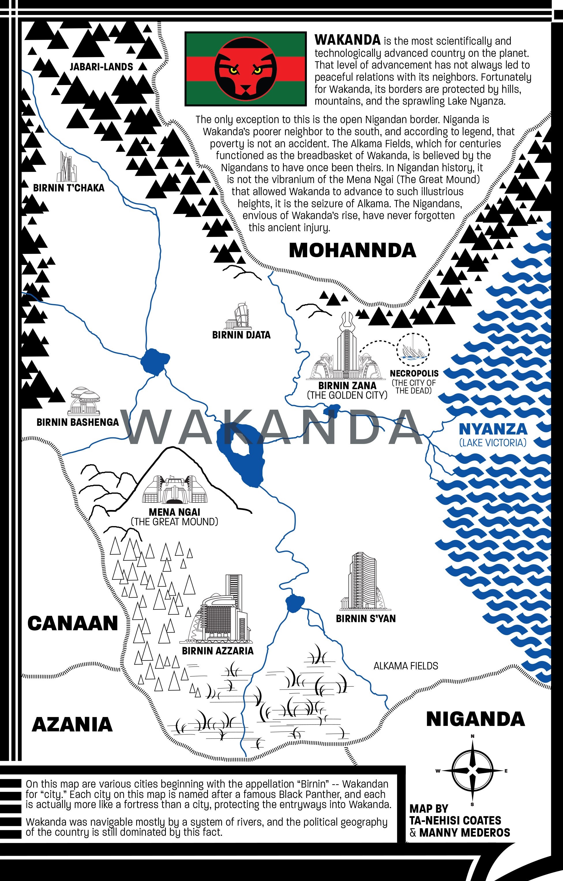
In 2016, a new version of the comic was written by Ta-Nehisi Coates. He drew a couple of new iterations of the map placing it on the western shore of Lake Victoria.
https://www.theatlantic.com/notes/2016/04/the-world-of-wakanda/479466/
The map above was created in Photoshop. Coates discusses his process in this article from The Atlantic. A later, more detailed version was done by Coates and Manny Mederos.
https://vignette.wikia.nocookie.net/marveldatabase/images/c/c5/Wakanda_from_Black_Panther_Vol_6_4_0001.jpg/revision/latest?cb=20160727172642
In the recent movie Captain America: Civil War, Wakanda appears to the northwest of Uganda, close to the location from Marvel's atlas. Here is a screenshot via comicbook.com
http://media.comicbook.com/2018/02/wakanda-1085186.jpeg
The current movie has it slightly to the southwest of the Coates map bordering on Rwanda's Lake Kivu. The image below is from Marvel's Black Panther: The Art of the Movie

Wakanda's location in Africa revealed in art book
Where will it move next?

Wednesday, April 5, 2017

Grand Theft Auto

I'm not much of a video game player so my ignorance of these things will be pretty obvious to the average gamer. Many video games have cool maps. What's interesting about the geography of Grand Theft Auto is that it is only sort of fictional - the names are different but the places are obviously recognizable. Here is a user created map of San Andreas created by Brazilian user DaniLekBom.
http://gtaforums.com/topic/447751-gta-mapmaking/page-124#entry1069187250
Names like "San Joan" and "Oakplace" are pretty thinly disguised. I like how he squeezed "San Donado" down at the bottom. You can just about see where the ESRI user conference takes place.

There's also a city in the desert. It's called Las Venturas. It has a strip! What was that inspired by? A couple of mysterious places inland like Endsville, Grapeseed and Coconut Springs have less obvious corollaries.

Vice City is another common locale in the game. Sometimes referred to as Vice-Dade County as if it wasn't obvious enough where it is.
http://i.imgur.com/iP2ZiDa.png
Liberty City is also a very familiar looking place. Here's a nice map of it. Lots of green spaces - including a largely empty "Staunton Island."
http://i.imgur.com/6DBJHwZh.jpg
A close-up detail...


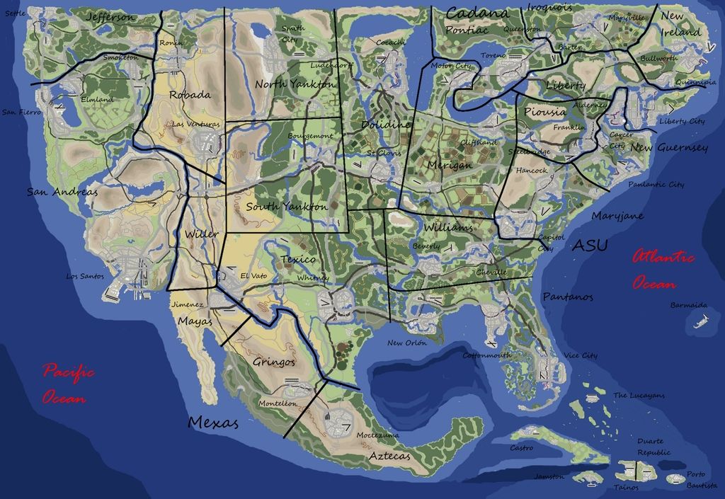
Here is the entire United States GTA'ed.
http://i1368.photobucket.com/albums/ag179/gtafan555/gta_america_map3_zpsssl6usgk.jpg
I like how the Dakotas are renamed North and South Yankton and New Jersey becomes New Guernsey.

You can find these, and many more maps, including Europe, Asia and Africa on the GTA Mapmaking Forum.
http://s1368.photobucket.com/user/gtafan555/media/gta_africa_1.9_zpssmpsuimj.jpg.html

NOTE: This is not an endorsement of a violent, sexist video game that may encourage crime and DUI (I don't know, I've never played.)  I'm only here for the maps.

Wednesday, December 23, 2015

Metro Santaland

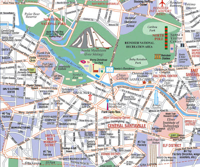
I've always thought of Santa's village as some quaint little place but according to Santa Lives Here, it's a pretty large city.
http://www.santaliveshere.com/
When you think about it realistically, of course you would need a large city in order to be able to be able to make and deliver toys for over a billion children. You need factories, but also amenities to keep the workers happy such as schools, parks and an eggnog district. So maybe my illusions have been shattered a bit but now I realize how complex the operation is. Enjoy your holidays and appreciate where all the good stuff comes from.

Wednesday, November 4, 2015

The Island of Bad Art

Artist Grayson Perry created this etching to look like a Renaissance-era map of Venice in conjunction with the 2013 Venice Biennale. The place names reflect Perry's categories of bad art-here are some examples.


Based on some of the internet commentary he seems to have offended many people which is what art should do. It may be a bit snooty, but the mappy details are well done and enjoyable. Click below for an enlarged, readable version.
https://s-media-cache-ak0.pinimg.com/originals/f2/d8/68/f2d8685121a0e0484f39a1c5f4a54088.jpg