Showing posts with label Portland. Show all posts

Wednesday, August 16, 2017

Tramways of Portland, Maine

I found some great old maps of the tramway system of Portland, Maine on a German Wikipedia page. Interestingly, there does not appear to be an English-language version of this page.
https://upload.wikimedia.org/wikipedia/commons/thumb/9/97/Portland%2C_Maine_-_Map_of_the_Horse_Rail_Lines_1876.jpg/1920px-Portland%2C_Maine_-_Map_of_the_Horse_Rail_Lines_1876.jpg

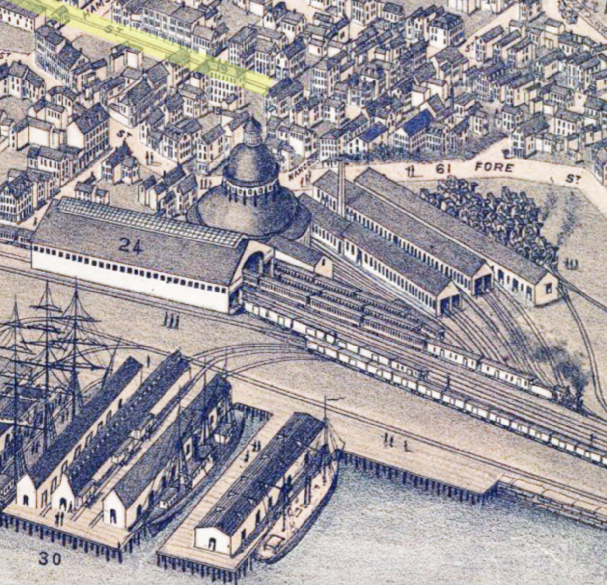
The city began a horse-drawn tramway in 1863. The image above highlights the tramways in yellow over a panoramic image from 1876. The details in this panorama are spectacular.

The map below shows the growth of the horse tram system from 1883 to 1896
https://upload.wikimedia.org/wikipedia/commons/f/fe/Portland%2C_Maine_-_Map_of_the_Horse_Rail_Lines_1883-1896.jpg
The Portland and Forest Avenue Railroad Company was founded in 1860 and began operating a horse drawn carriage system. The first section ran between Spring Street and the Grand Trunk Railway Station (shown in the panorama detail) opened in October, 1863. The fare for the entire route was 5 cents. The following year two more lines were added. The red lines shown above represent the system by the end of 1864.

The author,  Maximilian Dörrbecker traced the tram lines over a US Geological Survey map from 1916.

The lines were electrified starting in 1891. Over the next two decades the system expanded far into the suburbs.
https://upload.wikimedia.org/wikipedia/commons/c/c3/Portland%2C_Maine_-_Map_of_the_Electric_Railway_Lines_1891-1914.jpg
 A detail on the lower left side gives a good view of the extent of the system by 1902. Not shown are extensions to Lewiston, Falmouth, Saco and Old Orchard Beach.
Here is a bird's eye view from 1909.
https://upload.wikimedia.org/wikipedia/commons/thumb/c/c9/Portland%2C_Maine_-_Map_of_the_Rail_Road_System_1909.png/800px-Portland%2C_Maine_-_Map_of_the_Rail_Road_System_1909.png
Again the beauty is in the details.
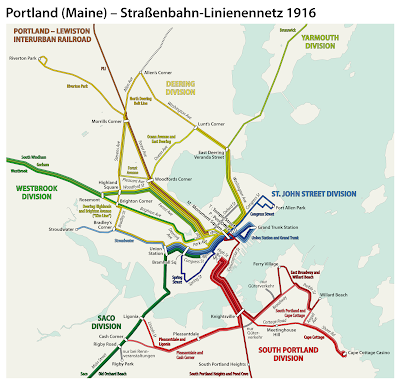
Here is a subway style map showing the lines at the system's peak in 1916.
https://upload.wikimedia.org/wikipedia/commons/e/ec/Portland%2C_Maine_-_Electric_railways_route_map_1916.png

After World War I the system began to decline. The suburban lines were abandoned in the early 1930's and by 1941 the entire system had been replaced by buses.

Wednesday, November 2, 2016

Portland's Floor Plan

My wife recently bought me Portlandness: A Cultural Atlas for our anniversary. Maps were created by students and at least in one case, children. As a result there is plenty of creative cartography to see. One of my favorites is this floor plan, titled "Putting Our House In Order"
https://www.pdx.edu/insidepsu/mapping-portlandness
In order to not run afoul of copyright restrictions, I will only show what is available on the book's web pages. The map is full of clever metaphors - the river dividing the city is the front hallway, industrial zones are bathrooms, Pioneer Courthouse is the living room, downtown the office, and bedroom communities are bedrooms. It is easy to guess the nature of less familiar areas like Alberta (craft room) and Gresham (garage) - I also like that the bluffs are the balcony.

The map also shows up on the cover
You can see the entire map using the "look inside" feature on Amazon.

Wednesday, September 28, 2016

Joan Blaeu's Remarkable World Atlas

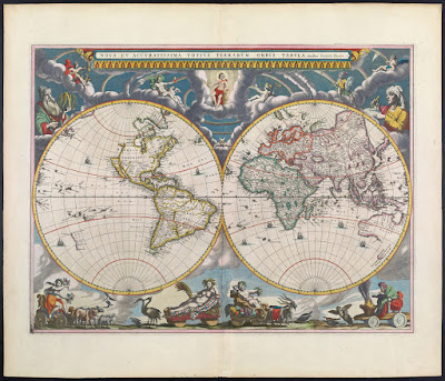
Joan Blaeu produced a remarkable 11 volume atlas between 1662 and 1665. It was the largest book published during the 17th Century. 
These volumes were meant to be the first part of a larger series. The title translates to "Grand Atlas or Blaeu's Cosmography, in which are most accurately described earth, sea, and heaven" with a second part about the oceans and a third about the stars. However, he did not live long enough to publish those volumes.

This summer I went to the Osher Map Library in Portland, Maine to see their Pictorial Maps exhibit (see my previous blog post for a review.)  The first map in the exhibit though not "American" or part of the "Golden Age" was from this atlas and meant to show an early use of pictorial decorations on maps.
http://oshermaps.org/map/458
While I was there, they let me look at a volume of this atlas. I chose the first volume and took pictures of various pages, including the map above (though the image from Osher shown above is much better than my photo.) It was an amazing experience to hold a volume of this atlas in my hands. Unfortunately between the lousy notes I took and my lack of knowledge of Latin, I don't have much to add to the photos I took - here they are.
From the Introduction - the orbit of the known planets, going out as far as Saturn.
The first volume is mostly focused on the Arctic regions. Above is the island of Spitsbergen, below is the adjacent island of Jan Mayen with some great (and probably very exaggerated) details.
More easily recognizable to most people, Iceland.
In addition to maps, the atlas has some great pictorial details including this Walrus illustration,
and whatever this totem is. If I could read Latin, I might be able to figure it out. Note: see comments for a good explanation.
There are also details of buildings and other public and religious spaces. Again, I don't know what we're looking at here.
UPDATE: Reader Ted Kottler has identified this as Tycho Brahe's observatory on the island of Hven (aka Ven), Sweden in the Oresund, the strait between Sweden and Denmark. 

I'll finish up with one more map. After much curiosity and digging around, I figured out that the map below is part of the Nordfriesland district in Schleswig-Holstein, northern Germany along the border with Denmark. I'm still not sure what the underwater streams are - some elaborate planned land reclamation, ocean drainage project?
Once again, I would like to thank the kind and helpful staff at the Osher Map Library for allowing me to see and hold this atlas. Though the pictorial map exhibit is over, there are still lots of great things to see there.

Wednesday, August 10, 2016

Pictorial Maps-a more detailed review

Last week I visited the Osher Map Library where The Golden Age of American Pictorial Maps runs through September 3rd. I did a very short blog post. Now that I have more time here are some more detailed highlights. Most of the exhibit's maps can be seen and zoomed into online at this link. I took my own pictures to give a detailed look at parts of the maps and also to make the text more readable

The "Golden Age" of American pictorial maps is defined as the 1920's-1960's, a time when maps were part of and a reflection of the popular culture.  There are seven parts to the exhibit - I will try and show highlights from each in order.


1. Early Pictorial Maps
The first map in the collection is actually not from this time period - it is from a 1662 Joan Blaeu world atlas.  The point is to illustrate an early version of a map with many pictorial elements.

http://oshermaps.org/map/458
After touring the exhibit, I got a chance to hold a volume of this atlas in my hands. The atlas is full of great details that I hope to revisit in a future post.

George Walker & Co., Bird's Eye View from Summit Mt. Washington (ca. 1905)
http://oshermaps.org/map/40687
 This is a spectacular art/map combination. Here's a picture I took of the summit.

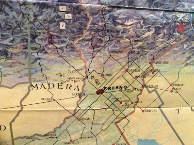
Fresno County and Mid-California's "Garden of the Sun" (author anonymous) is another one of my favorites:
http://oshermaps.org/map/4000155
Also in this section is the London Wonderground Map  that was the subject of a previous Map of the Week post.


2. Maps of Place and Region

Ilonka Karasz, Plan de Paris (1927)
http://oshermaps.org/map/4000160
Of course I love Paris but I also love the way the streets have hatch lines that make it look like they were stitched onto the map.

Carl Crow and V. V. Kovalsky Illustrated Historical Map of Shanghai (1935)
I liked the title block so I photographed it.
http://oshermaps.org/map/4000187

3. Maps to Instruct

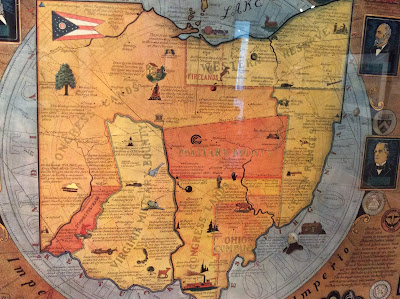
Arthur B. Suchy Ohio, Mother of Presidents (1939)
http://oshermaps.org/map/4000162
The regions are interesting and new to me-lots of good small details too.
Emma Bourne, America-A Nation of One People From Many Countries (1940)
http://oshermaps.org/map/4000182
This was published by the Council Against Intolerance in America to show how well immigrants have been integrated into society. "With the exception of the Indian all Americans or their forefathers came here from other countries." While I was at this exhibit, Donald Trump was across town trying to blame Maine's Somali immigrants for an imaginary rise in crime.

 Edward Everett Henry, The Virginian (1960)

a remarkably detailed map illustrating the first "western" novel.

4. Maps to Amuse
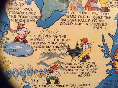
Ray Handy's Paul Bunyan map is some good, ridiculous fun.
http://oshermaps.org/map/4000166

Also, similar to my old Texan's map postcard is this Angeleno-centric "brag map"- proudly showing off local geographic ignorance. Chicago is a state but Wisconsin a mere city within Minnesota.  States are placed in ridiculous locations with a giant Iowa in the middle and phony places like "Feudville" in Kentucky.
http://oshermaps.org/map/4000146
5. Maps for Industry

Cleveland Terminal Group, The Capital of a New Trade Empire (1929)
Civic pride on steroids! I chose this one because my wife could find the intersection where she once lived on the map-it's right there in the lower right - see it?

Map of Michigan (Slightly Exaggerated) Shafer's Bakeries, Inc. (1949)
Similar to the LA "brag map" but also advertising bread ("such crust!") and using loaves as border decorations. Nice references to Florida as "Southern Michigan," California as "Western Michigan" and Chicago as the "Gateway to Michigan."

6. Maps for War.
 Ernest Dudley Chase, Japan, The Target: A Pictorial Jap Map (1943)
http://oshermaps.org/map/4000173
World War 2 in the North Sea Area...(1944)
http://oshermaps.org/map/4000171
This one was in a big glass display in the center of the room. As a result I was not able to get a picture without lots of reflections so use the link to see it better.

7. Maps for Postwar America.

There are lots of good maps in this collection, but I like this juxtaposition of an optimistic map of New York from 1958 followed by a gloomy view of LA from a decade later. The LA view features pink sky, smog and a sickly sun.

Nils Hansell, Wonders of New York (ca 1958)
http://oshermaps.org/map/4000176
Gene Holtan, Los Angeles (1968)
http://oshermaps.org/map/4000177
One final note: The staff at the Osher Library were extremely welcoming and helpful. Mr. Osher even dropped in to see what I was doing. I would like to thank them for all their help - and the lunch recommendation!

Thursday, August 4, 2016

The Golden Age of American Pictorial Maps

 Today I am posting live from the Osher Map Library where The Golden Age of American Pictorial Maps runs through September 3rd. I planned to do a "live blog" but this exhibition has greatly exceeded my expectations. In order to do it justice, I will need to do a more thorough post when I have the time. In the meanwhile here are some highlights. Here is the Buckminster Fuller Dymaxion Projection on the side of the building
Projected Global Air Routes- link
Rio-World's most beautiful (and maybe polluted) harbor. Site of tomorrow's Olympics
On the trail of Moby Dick-link
Dystopian LA with its Pepto-Bismol Sky-link
Also, they let handle an Atlas by Joan Blaeu!
More on that and everything else later.   

Thursday, September 27, 2012

The New IOS6 Maps

Any new mapping system is going to have glitches. It takes a long time and lots of user input to get to where google is and maybe Apple will always be a few years behind. In the meantime we can have lots of fun with their glitches. There is a page on Tumblr, The Amazing iOS6 Maps that collects these glitches.


Helsinki's Railroad Station as a park.

There are lots of melty pictures, a result of aerial and 3D image overlays. Here's a the Islington subway station in Toronto.


Other example include cities that have migrated, park expansion, missing water bodies and lost detail. Here is Minsk, a city of 1.8 million, with almost no roads and the city's center located outside the beltway.


Powell Butte in Portland, Oregon supersized.

Wilkes-Barre, PA moved inland after the flood.

Belgrade without rivers.

 There are dozens of additional pages of these images for your viewing pleasure. Just click the next button at the bottom of the page. Thanks to niece Olivia for discovering this page. I just got my new iPhone and will be setting it up later today so I have all this to look forward to. I'll leave you with this final parting shot.