Showing posts with label i often dream of trains. Show all posts

Wednesday, April 26, 2023

Earth Transit

 Earth Transit is a project by Zhaoxu Sui showing the major passenger rail lines of the world.

In his own words "This is the beta version, which means a lot of errors and mistakes could be on the map, please give me corrections and suggestions so that I can improve." Lines are color coded by railway companies. The ambition of this is huge and at this scale it is not possible to show all railway lines in places as dense as Europe,

or maybe China.

There is not an obvious link but you can download a high resolution image by clicking on the picture and saving it or from this link. It's fun (for people like me anyway) to pan around and see what the railway network looks like in places like Central Asia (nice mountains!),

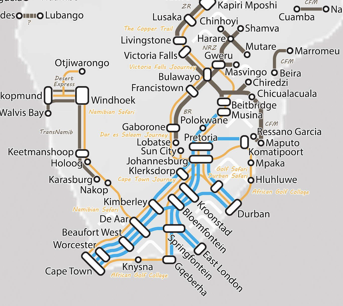
southern Africa,

 and Cuba.

Here are the railways I know and love in my part of North America.
More on the project here. Enjoy!

Wednesday, June 17, 2015

California Rail Map

Alfred Twu and a team of designers made a subway-style California Rail Map. Here are a couple of screen shots - the whole thing can be seen here.


Like most subway style maps the geography is distorted, in this case to a crazy degree. The San Francisco peninsula sticks way out like a sore thumb, grotesquely swollen actually. Yes, the top of the image below is Oregon.
To fully appreciate the distortion, I made my own map of the state's shape according to Twu, et al.


Of course the implication of good transit is very overstated here. Some of these routes only run once a day and many don't run at all on the weekends. Still it's fun to imagine a car-free California.

Wednesday, May 20, 2015

Live Animated Trains!

TRAVIC is a visualization of public transit around the world, using live feeds where available and otherwise using schedule data.
TRAVIC is a collaboration between Geops, a German geospatial company and the University of Freiburg. The major and even minor transportation authorities in Europe, North America, Australia and New Zealand are covered along with a few other cities on other continents. When zoomed out to a continental scale, you can see how well covered Europe is.
Here is the coverage in my neck of the woods.
As you zoom in further you see the vehicles. At the local scale they begin to move. Here are some still frames from Philadelphia.
I chose Philadelphia partially out of my personal bias, but also because it's one of the few places in North America that actually labels the commuter trains by destination, adding a layer of interest.
The larger orange dots are for the Broad Street Subway (Orange Line) and the smaller blue dots are bus routes. Clicking on a vehicle brings up schedule information as seen in this screen shot from Berlin
I'll leave with an animated shot from America's hardest working transit system. Watching the trains going under the East River is the best part.
Thanks to Urban Demographics for alerting me to this site.

Wednesday, June 25, 2014

Quest for Nevada Complete!

Here is one final self-indulgent post about the quest for my 50th state. After this I can get back to more interesting (to the rest of you) stuff.

The quest is complete! I reached my 50th state-Nevada late at night on Amtrak's California Zephyr. Although there is no "Welcome to Nevada" sign along the train tracks (at least not visible at night) you know you're at the border when you go through Wendover, Utah and then into West Wendover, Nevada. These are the only towns after dozens of miles of salt flats so it's pretty obvious when you've arrived.
The map above shows our entire route. It bleeds off the edge of the allotted space here but you can click to see the entire thing. We flew into Denver and spent a day and a half there, then took the train to Reno. Next we rented a car and drove down to Lake Tahoe via Virginia City. After a couple of nights in Tahoe we drove down to Yosemite National Park and then on to Oakland for a wedding, followed by a flight out of San Francisco. All in all it was way too much to try and do in a week but well worth it! A few more details and photos can be seen on Twitter-see the sidebar to the right.

Just to get really self-indulgent, here is my updated county map.

Wednesday, May 28, 2014

Fifty Years! Fifty States!

Some of you know that I just turned 50 on Tuesday. I have been to 49 states so this is a good year to get to 50. Here is the map hanging in my kitchen showing all the counties I've been to.
My last state is Nevada. In a couple of weeks my wife and I plan to go to Lake Tahoe. The #AmtrakResidency got us excited to get on a train. Rather than waiting for the unlikely event of being chosen out of tens of thousands, we will do our own #DIYAmtrakResdidency. We are taking a 25 hour ride from Denver to Reno followed by a drive to Tahoe. 

If or when I can I will blog and/or tweet the event. There is probably no Welcome to Nevada sign on the tracks and it will be the middle of night so it may not be as fun as posing with my wife at the North Dakota border for her 50th. However, it's still exciting to me. Stay tuned. 

Wednesday, March 19, 2014

#AmtrakResidency

http://blog.amtrak.com/amtrakresidency/

I just applied for the Amtrak Residency program. This is a cool idea originated by writers discussing their inspiration from train travel on Twitter. Amtrak's social media people picked up on this and decided to offer free train tickets to writers. While not a traditional writer, I am "passionate about train travel and writing" and might offer a unique perspective as a blogger - at least that's what I told them on my application.

https://twitter.com/MapOfTheWeekOne of the requirements of this program is a Twitter handle so I'm finally on Twitter! You can follow me @MapOfTheWeek - note my sidebar.  


With only 24 slots and over 10,000 applicants (so far) my chances are slim but I can still dream about it with a little help from Amtrak's nice maps,
http://www.amtrak.com/san-francisco-bay-area-northern-california-train-routes
 their interactive atlas,
http://tickets.amtrak.com/secure/content/routeatlas/index.html
and their "Track a Train", where you can see where each train is at any given moment. See the bottom left of their home page to activate.


Wednesday, February 26, 2014

Los Angeles and "Her" Future Transit System

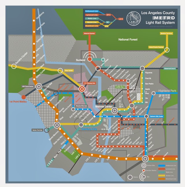
One of the Best Picture nominees in Sunday's Academy Awards is Her. The movie takes place in a future LA with skyscrapers and a much more comprehensive transit system. There is a scene in the movie that was shot in a subway (or light rail) station. This map is in the background.
http://gizmodo.com/a-map-of-the-futuristic-los-angeles-subway-from-spike-j-1499580805
The map was designed by Champion Studio and posted on Gizmodo. The designers had fun with it giving stations names like Hair Salon and Private Drive. There are a number of other odd touches like a stop in the river, several lines not listed in the legend and a fictional transit authority.
http://championdontstop.com/site3/clients/Her/Her.html
The LAMLR has a nicely designed logo featuring an elevated train and the words "Sea to Summit." For more details and a readable map see the Gizmodo post.

Thursday, October 8, 2009

Map of the Week- The Ski Train

We spent part of a rainy Adirondack Saturday at the North Creek Depot Museum. The museum has some Theodore Roosevelt history and lots of interesting ski industry relics including gondolas, tow lift ropes and skis. It also has a great model of the Upper Hudson River Railroad and, of course, maps. Here is a 1948 map of the trails from the depot to the slopes.

People would pay $2 to ride the Ski Train to North Creek. They could start skiing right from the depot or pay 50 cents for a truck or taxi ride up one of the slopes. Gore Mountain was not yet built as a ski resort so skiers used this network of trails, most of which have since been abandoned.
Unfortunately they did not have copies for sale so I only have this low resolution image courtesy of the Albany Times Union.

While digging around for that map I also found this statewide scenic railroad map online.

The nice thing is that they've brought together all the tourist railroads and museums onto one page and map. The map itself could use some work. For, one thing it would have been easy to make the cute railroad signs into links. The overemphasis on New York's tourist regions is also a bit distracting. Long Island is missing but if they don't have scenic railroads there then I can live with that. Some of the cities are poorly located and Troy is missing - that's just not right!