Showing posts with label california. Show all posts

Wednesday, May 6, 2026

An Evening at The Map Center

I’ve been meaning to go to The Map Center since I met proprietor Andrew Middleton about 2 years ago at an event. Middleton won a contest to take over the store from its previous owner and moved from California to Pawtucket, Rhode Island to run the place. Finally, a Geospatial Professionals Network event was my excuse to head to Pawtucket.


There are very few map stores left in the United States and most of them specialize in antique maps. The Map Center has carved out a niche in the more interesting (in my opinion) world of creative and eccentric maps.


Also included are books, post cards and other ephemera such as this tray.


For me, it was like being a kid in a candy shop.


Here are some sample books.


Here is a piece of an old Russian rail map.

All the Hams of Massachusetts by Ricky Rainbow Beard.


Of course, I couldn’t leave without buying a bunch of stuff I don’t need*, including this T-shirt,


and a hard copy of the wonderful Cross-Sections through California by RJ Andrews. 


*About the “stuff I don’t need” quote, Middleton says “no one will have their day ruined for lack of a thing I sell. But I do hope it makes people's lives richer and more filled with wonder and curiosity.“

It’s tough running a map store in an age of ubiquitous internet maps and GPS. He is planning on doing some more experiential stuff- classes in QGIS, event hosting and art exhibitions for that very reason. I hope the store survives so I can continue buying items that make my life richer.

Wednesday, June 25, 2025

In 1977, the Kinney Shoe Corporation, in cooperation with the President’s Council on Physical Fitness put out a series of walking tour brochures for historical sites across the United States. Perhaps the idea was, walk more, wear down your shoes and buy some more.

Here is an example from Paterson, New Jersey, “America’s first great industrial city”. Alexander Hamilton saw the power potential of the Great Falls of the Passaic River, the second largest waterfall east of the Mississippi River.

The walks range from rustic, historic ambles (I chose this one for both personal history and because it’s near where I’m writing this from),

 to college towns,

 to downtown tours,

 museum and garden loops,

and finally to a “redwood grove near Santa Cruz”.

Along the way, you learn about the ghosts of F. Scott Fitzgerald, Thomas Mann and John O'Hara haunting the libraries and tap rooms of Princeton, Chicago's architecture, the friendliness of Woodstock, Illinois, miscellaneous redwood facts and that Scottsdale, Arizona has some of the "prettiest women".
 

Wednesday, April 30, 2025

Mapping The Surf

Malin and Mizen is a company that makes specialty maps like the California Surf Map 

 I love the wavy lines and details showing ideal wind and swell directions, coordinates, shark sightings, etc. The hand drawn details on the land are also very nice. 


The company is named for Malin and Mizen Head, the northernmost and southernmost points in Ireland. Here you can see North Malin from the Irish Surf Map. 


They make maps for different sports, history and beer and wine. Here is part of the Irish Pub Map. The x indicates where hot food is available. 


Here is some detail from the California Vineyard Map, the letters indicate grape types and the other symbols are for visiting and tasting information. 


There are also many swimming and golf maps. 


Other surf maps include Australia with its varied topography. Kangaroos and ostriches dot the land. 


Finally, closer to home (for me) is New Jersey. 


Wednesday, July 1, 2020

Sea Level Rise-Coming to a City Near You

Conspiracy of Cartographers has a series of maps showing what will be underwater in various cities after 215 feet (66 meters) of sea level rise. Keep in mind that this is "end point" sea level rise and not anything we would see in our lifetimes. A recent page highlights new maps of Philadelphia,
https://conspiracyofcartographers.com/2019/10/12/philadelphia-sea-rise-map/
and Washington, DC.
https://conspiracyofcartographers.com/2019/10/12/washington-dc-sea-rise-map/
Both maps show similar patterns with the central cities completely flooded and the land being mostly peninsulas in the hilly north and western suburbs. There are also some nice puns.
In Philadelphia, Hunting Park becomes Fishing Park, University City becomes Irreversibly Pity, Wayne Junction, Drain Junction, and Northern Liberties is now Northern Fisheries.

Other maps have been done for cities in the U.S., Australia and England as well as a few larger regions. Here are Cascadia,
 The Palm Springs-Coachella area of California,
an almost completely waterlogged Brisbane,
and Los Angeles, featuring one of my favorite puns- the Ex-LAX airport.


Thursday, October 10, 2019

Gang Injunctions Map-Los Angeles

The controversial practice of gang injunctions, in which individuals or entire gangs can be restricted from associating with friends or even family members in certain neighborhoods, has been blocked for now in Los Angeles. Over the last few decades the city has enforced injunctions against 79 gangs encompassing some 8,700 people - via the Los Angeles Times.

The injunctions, while credited by law enforcement officials with helping limit gang activity, are controversial because they can affect individuals who are not involved in any gang activity. Those affected have not had a way to challenge these restrictions in court and can be subjected to unnecessary harassment.  The LAPD has a set of maps on their web site showing the neighborhoods affected by injunctions. Here is the citywide map.

http://assets.lapdonline.org/assets/pdf/COLUMBUS%20STREET%20GI%20gang_injun_citywide_85x11.pdf
These injunctions have been common throughout California. Here are maps from Anaheim,
https://www.ocregister.com/wp-content/uploads/migration/mgq/mgqzp7-mgqzh4anaheimganginjunctionarea.gif?w=620
and Long Beach, both via the Orange County Register,
https://www.ocregister.com/wp-content/uploads/migration/n3b/n3bkul-b781285758z.120140331142400000gm01j596f.4.jpg?w=1024&h=670


Wednesday, August 28, 2019

Getting Personal at the La Jolla Map Museum

For a final post of my Spring visit to the La Jolla Map & Atlas Museum I want to spotlight a few maps that are interesting to me for various personal reasons.
Photo courtesy of the La Jolla Map & Atlas Museum
This map by William Faden shows the movements of George Washington's troops against the King's army in New Jersey in 1776 and 1777. Faden's 1777 map of Philadelphia hangs on my wall and part of it appears on the header image at the top. The New Jersey map has lots of bits of historical information but this less important detail in the southwest corner is what interests me the most.
My childhood home is at the bottom of the map, just a little south and east of Middletown (now Langhorne, but the surrounding area is still Middletown Township). We would often take the drive to Newtown to get ice cream and visit the stores. It was a nice country drive to a nice little town. Newtown is still a quaint olde towne but is now surrounded by a partial beltway and a sea of ugly (IMHO) housing developments. I like seeing this view of Pennsylvania before runaway development.

Woodblock map of Edo (Tokyo) ca 1840 from the Shogun period.
Photo taken at the La Jolla Map & Atlas Museum
I have always been fascinated with Japan and especially Tokyo. I also love woodblock maps and all the tiny details found within them.
There is a detail page on this map on the museum's web site.

I took this photo and then rotated the map, out of habit of wanting to see north up. The map is actually reverse "oriented" with west at the top. My rotation was a kind of accidental mistake but I've left it this way because it fits the blog dimensions better. Here is the description from the museum's page.

"beautiful woodblock map of Tokyo from the golden age of Japanese woodblock map printing. Combining the elements of traditional Japanese map-making: rice paper, woodblock printing, delicate application of colour, the inclusion of topographical views into the map proper, and all text seems to radiate from the centre of the map; with a more modern western-influenced directional orientation with north to the right of the image. "  
Here is a bird's-eye view of Avalon on Santa Catalina Island in southern California. I've never been there and I don't know exactly why this map speaks to me. It just looks like a warm, welcoming town nestled in among the mountains - probably with crazy high real estate prices.
Photo courtesy of the La Jolla Map & Atlas Museum
Downtown detail.
The map is surrounded by images both real and fanciful of seals, buffalo, mermaids and people having all kinds of recreational fun. Here is one showing the road signs.
This last item is of interest due to its uniqueness. It is a display case used by Folsom Brothers to sell real estate in San Diego.
The case folds closed like a suitcase to carry around. The map is a relief map showing the topography in detail.
Here is the handle just west of Point Loma


Tuesday, June 11, 2019

Pictorial Maps from the La Jolla Map Museum

In one of my final posts from my March visit to the La Jolla Map & Atlas Museum, I will show some of their large collection of pictorial maps. They just opened a new room dedicated to these maps including many by Jo Mora, an artist and photographer originally from Uruguay who moved to California, the subject of many of his pictorial maps.
Photo taken at the La Jolla Map & Atlas Museum

Photo taken at the La Jolla Map & Atlas Museum
More on the map above can be found in a previous post.

Another popular collection of pictorial maps is the "Hysetrical Map" series by the Lindgren Borthers.
Photo taken at the La Jolla Map & Atlas Museum
This one is titled "A Hysterical Map Of The Mother Lode Where California Was Born and Hell Was Raised." It's full of jokey details such as "Gold is often found in sand but so is spinach" and "An ass covered with gold has more respect than a horse with a pack saddle." There are also maps of Yellowstone and the Grand Coulee Dam featured on the museum's web page.

A 1963 tourist map of southern California grandiosely titled "Ride the Roads to Romance along the Golden Coast thru the Sunshine Empire of Southern California" shows historic trails emanating out for Los Angeles City Hall,
Photo courtesy of the La Jolla Map & Atlas Museum
to charming mountains, orange groves and historic missions.
Photo courtesy of the La Jolla Map & Atlas Museum
The edges of the map show natural and historic vignettes.
Photo courtesy of the La Jolla Map & Atlas Museum
Harrison Godwin's 1927 map of San Francisco ("where the sun never scorches and the water never freezes") is one of the most detailed pictorials packed with facts, figures, "whimsical vignettes" and transportation info.
http://lajollamapmuseum.org/maps/map-san-francisco-showing-principal-streets-and-places-interest
I was not able to get a good up close photo but here is a screen shot via the David Rumsey Map Collection.
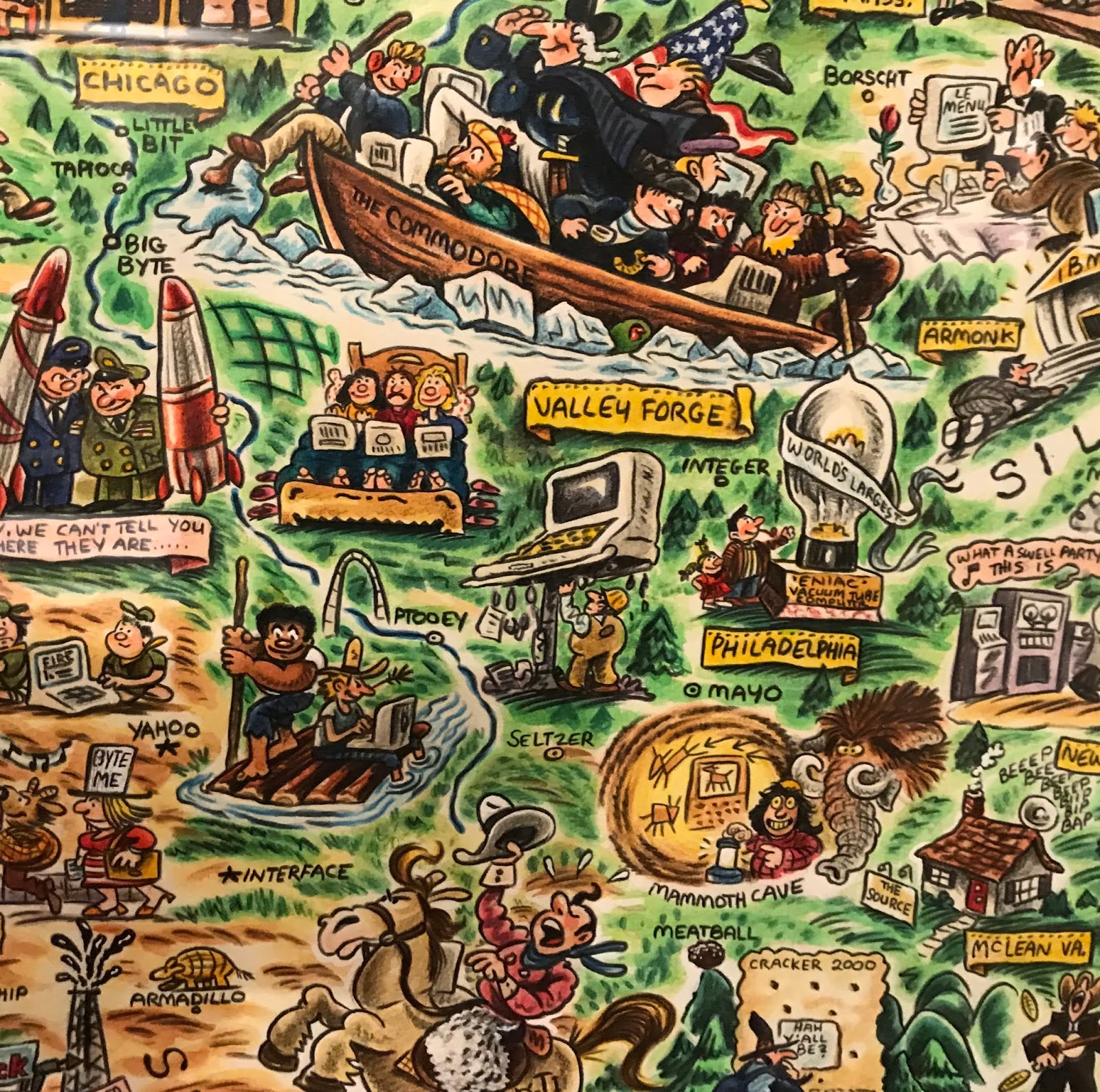
For a slightly more "modern" take here is the "Digital Deli Map of Personal Computer America" by illustrator Rick Meyerowitz, most famous for his work for National Lampoon. The map highlights Silicon Valley culture.
The bottom of the map contains a list of highlighted companies.
Highlights include a hiker in the Cascades carrying a large PC on his back with the screen reading "You are lost" and people in hot tubs looking at their computers. Here is part of the less important and therefore compressed eastern two thirds of the country.