Wednesday, January 26, 2022

The Russian Military Buildup

Here are a few maps to illustrate the recent arms buildup on the Ukrainian-Russian frontier.

This, from Reuters via The Guardian shows new military units in orange. Switching the orange and red would have made more impact. The article describes the buildup as insufficient for a full scale invasion, and one more likely to result in a more focused attack on the eastern regions of Donetsk and Luhansk, possibly targeting the port city of Mariupol.

This is a map from last month via Foreign Policy. I have cropped it to better fit this window. The whole map can be seen here.

There is no legend but the reddish color of the diamonds refers to "hostile" units, the X inside oval refers to combined infantry and armored divisions and the number of x's refer to numbers of units. The map is from a "Ukrane Defense Official". There is a good page of NATO military map symbols on Wikipedia that summarizes several hundred-plus page pdf's.

Wednesday, January 19, 2022

Pictorial Stamp Map

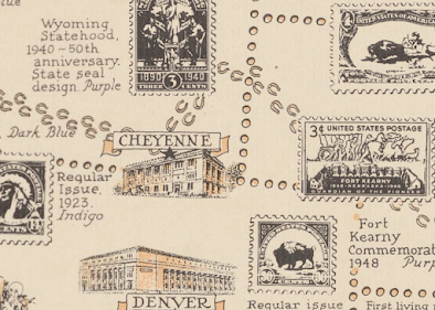
This map was created in 1947 for the 100th anniversary of the first United States postage stamp. Authored by Ernest Dudley Chase of Winchester, Massachusetts (one town away from me), it shows stamps that mark geographic locations across the United States.

The states are stamp-like, with perforations at the state lines and torn at the country and water boundaries.

Even Lake Okeechobee is perforated.

There is a brief history of postal delivery from the early Persian kings hovering over the Minnesota-Dakota border area. It includes the US Postal Service motto and seal at the bottom.

Facts about air mail hover over Texas.

The north arrow has the USPS sesquicentennial stamp in the middle and is flanked by postmarks from various locations including Winchester, Mass.

The Pony Express Route is detailed in horseshoes.

Along the top are a series of stamps showing educators, authors, poets, scientists, etc., while along three sides are various other commemorative stamps. The color of the stamps is listed because this appears to have been made with a two color press.

A little text area hovering over Dallas: "Postage stamps are beacon lights of history, monuments of heroes, gems of art, disseminators of universal knowledge, records of achievement, and mute witnesses to the rise and fall of empires." Heavy.

Tuesday, January 11, 2022

Redistricting Mini Golf

To show the absurdity of congressional district shapes, Dylan Moriarty and the Washington Post have designed this wonderful miniature golf game you can play online

Above is the Ohio 1st District. Republicans split Cincinnati into three districts to dilute that city's voting power. While not nearly the trickiest hole to play you have to squeeze the ball through the narrow gaps of Cincy.

The game begins in Wyoming, a state with only one district, therefore not one that can be manipulated. You can see from the layout that each district, or hole has an info box describing its demographics and voting patterns. 

The Illinois 4th District is famous for its "earmuff" shape, packing the Hispanic vote into the Midwest's only Hispanic-majority seat.

Indiana 7 is a trick hole. While the district looks very regular in shape, it is still designed in a highly political way by packing all of Indianapolis into it.

The toughest to play, by far is Maryland's terrible third. The water traps are completely unforgiving. 

You can see how I struggled with it by looking at my score sheet. Even with a generous par of 26, I was up to about my 50th stroke when I got caught in an impossible water situation and had to bail out.

Here is my final score sheet. I accidentally skipped the bonus hole-the original Gerry-mander in Massachusetts. This was my second go around so my scores on the other holes were pretty good. You have to play it at least once to get the hang of it. Have fun!

Wednesday, January 5, 2022

Routes to the Riot

A year ago "patriots" traveled across the country to stage a terrorist attack on the US Capitol to stop a democratically elected President from taking power, because that's what patriots do. Here are some maps of the routes taken. These are from the Colorado Times Recorder, a news organization that I know very little about so this is not meant as an endorsement of them.

The routes are the "cowboy route" for people from the west, the "rebel route" for southerners and the "minuteman route" for the northeast. Once there they had this map, featuring white supremacist hero Pepe the Frog, to orient them and keep them away from the "unsafe" zones, ie. places where non-white people live.
  
Looking forward to a new year where half the members of Congress continue to pretend that none of this ever happened.