Showing posts with label kentucky. Show all posts

Wednesday, May 22, 2019

Mammoth Cave

Map of the Mammoth Cave: Accompanied with Notes - via Library of Congress
https://www.loc.gov/resource/g3952m.ct001823
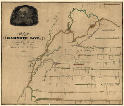
This is a remarkable map from 1835 (Doolittle & Munson, Cincinnati) showing the geographic view alongside diagrams of each section or "room". 
Different colors are used to differentiate the sections to help unify the section drawings with the map.
Here is the area under Mr. Gatewood's House, near the cave's mouth,
and the view from below.
The map includes a view of the mouth of the cave above the title block.
Here is the mouth on the map.


Wednesday, February 25, 2015

A Trucker's Odyssey

Bloomberg Business reporter Jennifer Oldham accompanied Tracy Livingston, a long-haul trucker on a six day journey involving two round trips between Michigan and Tennessee. The article provides a good, empathetic picture of the trucking life. They did an excellent job of mapping the journey.
http://www.bloomberg.com/infographics/2014-12-17/truckers-odyssey-six-days-on-the-road.html
You can click above for better resolution. Here is a detailed section.
The route is color coded by day. Icons are used to represent stops for gas, food, caffeine (a necessity when working 14 hour days) and various other needed diversions. These icons use the same colors for each day and add some personality to the map.

Thursday, July 25, 2013

Where Does That River Go?

If you're like me you look at a stream and wonder where it comes from or where it goes. The National Atlas has a new tool called Streamer. Click on a stream and you can trace it up or downstream. Here is the path of Butternut Creek in Charlotte, Michigan to Lake Michigan.
Tracing upstream is much more complicated. You get all the possible tributaries above you. Here's a trace of the Tennessee River near its mouth in Kentucky.
Unlike Streamer, rivers do not care about national boundaries. If you trace the Pend Oreille River downstream from Idaho, you get stuck at the Canadian border in Washington. The river itself only makes a short trip into Canada where it empties into the Columbia and heads right back into Washington but this is not shown in Streamer.
I like a good long windy path like the one made by Cassadaga Creek south of Buffalo. It starts just a few miles from Lake Erie but goes the other way instead.
Or Wyoming's Wind River.
Pick your favorite river (if you have one) and give it a try.