Wednesday, September 24, 2014

The Perils of Ancient and Modern Travel

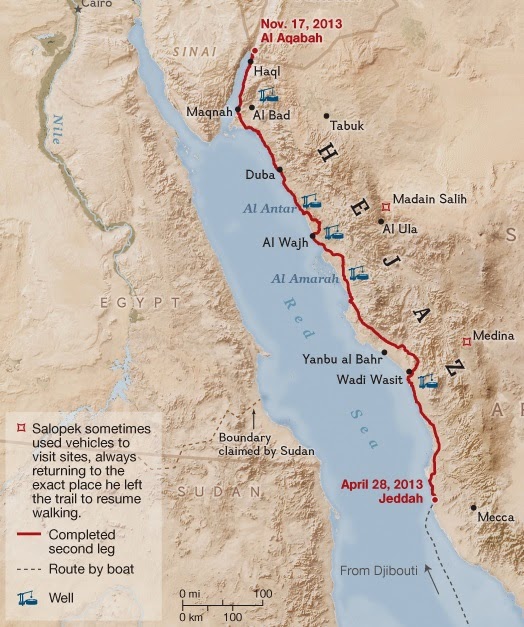
An ongoing series of articles in National Geographic detail Paul Salopek's walk to trace the spread of humans throughout the world. In the most recent installment, he walks across the Hejaz of western Saudi Arabia, visiting ancient wells - the blue symbols on the map.
http://ngm.nationalgeographic.com/2014/07/hejaz-desert/route-map
These wells were located a days walk away so that travelers would be able to traverse the desert region. Knowing the location of the wells was a matter of life and death.

And now for something completely different - a ridiculous comparison!

Today's electric car pioneers face a similar difficulty. Routes must be carefully planned around the location of charging stations. A recent article in the Mercury News details the first cross country trip in a Tesla by John Glenney. The article includes this map of their charging stations.
http://www.mercurynews.com/portlet/article/html/imageDisplay.jsp?contentItemRelationshipId=5692710
Tesla has a network of charging stations located close enough (about 265 miles per charge) to be able to travel certain routes across the USA. During Glenney's trip the Hagerstown, Maryland facility was not ready. He had a stressful trip from Newark, Delaware to Somerset in western Pennsylvania, arriving with only 11 miles left on his charge.

As the Tesla network expands, trip planning will gradually become less important as it has in Saudi Arabia, where drivers can find bottled water at gas stations. The wells now sit abandoned as traffic rushes past and planes fly overhead.

Wednesday, September 17, 2014

Scotland's Independence Vote In Maps

Tomorrow Scotland votes on independence. I don't have a "dog in this fight" though there is a "Duggy Dog" starring in a pro-independence video.
This map does a nice job of illustrating the political situation in service of the Yes campaign.
http://wingsland.podgamer.com/wp-content/uploads/2012/04/advertdraft2b.jpg
The Yes campaign also has a video titled Scottish Weather Forecaster Loses It Live On Air with some good map content. Here are a couple of still frames.
On the "No" side there's this map from The Economist full of typically snooty Economist cliches.
http://i.telegraph.co.uk/multimedia/archive/02192/the-economist_2192486a.jpg
We get it. They're a buncha moochers!

Finally, there's the cover of The Battle for Britain by David Torrance...
https://www.bitebackpublishing.com/books/the-battle-for-britain-paperback
... and its copycat images.
http://www.zazzle.com/scottish_independence_cut_here_map_postcard-239672291035838057
http://www.presstv.ir/detail/2013/05/01/301204/scots-indep-end-of-uk-as-power-mps/


Tuesday, September 9, 2014

Franklin Expedition Ship Found

The Canadian Government announced today that they have found one of the two ships from the ill fated Franklin Expedition of 1845. While searching for the Northwest Passage, the expedition's ships became trapped in ice and the crew was never found. Sonar images from the waters of Victoria Strait, just off King William Island, show a wrecked ship on the ocean floor.  
http://www.pc.gc.ca/eng/culture/franklin/index.aspx
The wreck location is approximately at the northern ship on this Parks Canada map. The map is nice but could use a "leader line" to connect the inset to the main part of the map, otherwise you might think the area is in Saskatchewan.

These quotes from CBC detail how Inuit hunters of the 1840s helped direct the search:
 "The beauty of where they found it is it's proof positive of Inuit oral history," CBC chief correspondent Peter Mansbridge, who has covered the Franklin search for many years, said Tuesday.

"The Inuit have said for generations that one of their hunters saw a ship in that part of the passage, abandoned and ended up wrecking…. It's exactly where this guy said it was."

Canadian Geographic has a nice detailed map of the search area. It's not completely clear from the articles and announcement exactly where this find is but it appears to be very close, if not in the area outlined below.
http://www.canadiangeographic.ca/franklin-expedition/assets/victoria-strait-expedition-map/


Wednesday, September 3, 2014

This Pizza Proves Vietnam's Sovereignty Over Islands

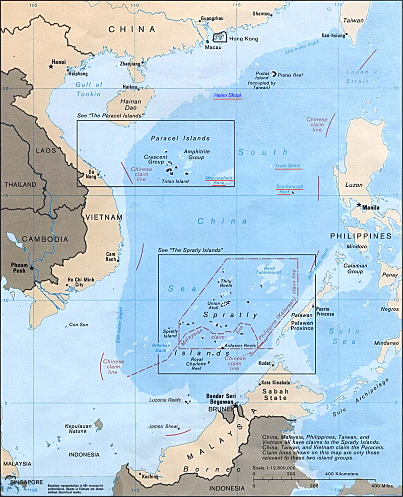
Students at Hoa Sen (Lotus) University in Ho Chi Minh City (aka Saigon) made this pizza after a dispute with China over control of the Paracel (Hoang Sa) and Spratly (Truong Sa) archipelagos in the South China (or East Vietnam) Sea.
http://tuoitrenews.vn/lifestyle/20005/students-make-mapshaped-pizza-to-support-vietnams-sovereignty-over-islands
Tuna from nearby waters was used to shape the archipelagos. Boundaries and details were made from shrimp, chicken and mushrooms. This project was a response to the Haiyang Shiyou 981 standoff, China's deployment of an oil rig in the waters near the Paracel Islands (claimed by China, Vietnam and Taiwan) over the summer. See tuoitrenews for more details.

Here is a map from Wikipedia outlining the disputed archipelagos.
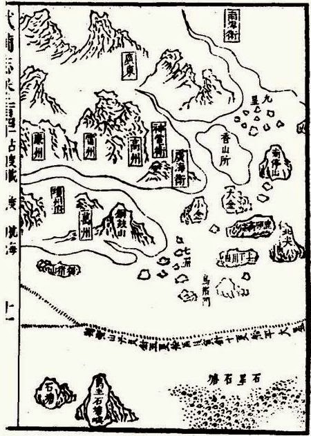
 For some older context here is the Paracel Islands as shown in Zheng He Voyage Map (the group of rocks at the lower right hand corner)
http://en.wikipedia.org/wiki/Paracel_Islands#mediaviewer/File:MAO_KUN_MAP-19.jpg
 "MAO KUN MAP-19" by Mao Kun - mybook. Licensed under Public domain via Wikimedia Commons - http://commons.wikimedia.org/wiki/File:MAO_KUN_MAP-19.jpg#mediaviewer/File:MAO_KUN_MAP-19.jpg