Showing posts with label delaware. Show all posts

Wednesday, November 27, 2024

The Salt Front

The salt front is the point where a river becomes too salty to be safe for drinking water. The front moves upstream from the river’s mouth as less freshwater flows downstream to dilute it. I’d never heard of a salt front until I read about it in a recent article in the Philadelphia Inquirer. The region’s severe drought in November caused this front to move significantly further upstream than the median monthly location.


On the map above, via the Delaware River Basin Commission (cropped for ease of reading), the pink area is the median salt front location and the pink arrow shows the normal location of this front in November, near Wilmington, Delaware. The blue arrow shows the location as of November 18, 2024. 

The DRBC monitors freshwater flows to keep the salt front from migrating too far upstream. This protects drinking water and industrial water intakes. There are major drinking water intakes for both Philadelphia and New Jersey at the blue box on the map. One way to keep freshwater flowing is to release water from various upstream dams.

The worst droughts were in the mid 1960’s-this shot from one of their videos shows the most upstream movement of the front on November 20, 1964,


and here is a still map showing more specifically the salt front’s furthest upstream location during the “drought of record”


Finally, here is a screen shot from the hydrologic conditions dashboard, showing conditions on November 23, 2024.


Wednesday, April 8, 2015

Gotham City Mapped

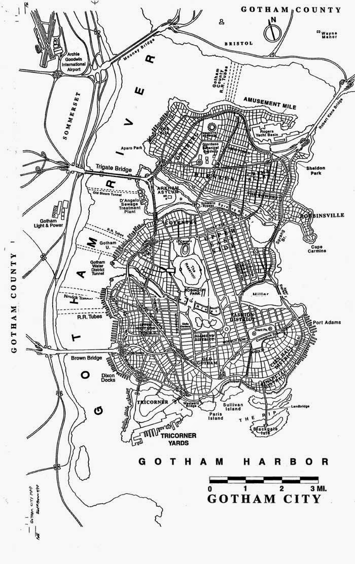
Batman co-creator Bill Finger first named Gotham in 1940 for Batman #4. However, the city was not mapped until 1998, when a plot involving a catastrophic earthquake required a map. Artist and illustrator Elliot R. Brown was hired for the task.
http://www.eliotrbrown.com/0001.php
The city has always had a resemblance to New York but, according to Finger "We didn’t call it New York because we wanted anybody in any city to identify with it." With no formal training in cartography, Brown was tasked with creating a city that had all the necessary diverse elements.
"The DC Comics editors made it clear that Gotham City was an idealized version of Manhattan. Like most comic book constructs, it had to do a lot of things. It needed sophistication and a seamy side. A business district and fine residences. Entertainment, meat packing, garment district, docks and their dockside business. In short all of Manhattan and Brooklyn stuffed into a … well, a nice page layout." - Brown
Early sketches of his map can be seen on his website, including this one.
The city needed to be an island so that federal agents could seal it off from the mainland by dynamiting the bridges and tunnels. In addition to the New York elements, he also added some "Chicago-like" bridges in the middle of town, to "add some story potential."

Here is one version of the final product as it appeared in the comics circa 1999, via Smithsonian.
http://www.smithsonianmag.com/arts-culture/cartographer-gotham-city-180951594/?no-ist
So where is Gotham City? It is often considered to be on the east coast of the United States but it's an open question due to some contradictory descriptions of it's location. From io9's Is Gotham City Really in New Jersey?
Gotham also has been hit by earthquakes (1999's No Man's Land...), sits in the Central Time Zone (Man-Bat #3), and was a cowboy town in the 1800s (2011's All-Star Western).
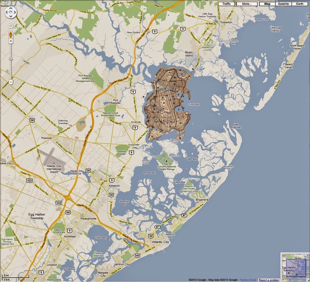
The Batman wikia has a modified google map placing Gotham in Great Bay, just north of Brigantine (and Atlantic City), New Jersey.
http://batman.wikia.com/wiki/Gotham_City
The io9 page shows this image from a 1978 comic also placing Gotham in South Jersey but on the Delaware Bay, across from Metropolis (Metropolis, Delaware?)
http://io9.com/5934987/is-gotham-city-really-in-new-jersey

That's a lot of action for an area mainly populated by horseshoe crabs.

Wednesday, August 21, 2013

Corporate States and Booze States

A couple of months ago graphic designer Steve Lovelace posted this map of the Corporate States of America, subjectively showing the corporation that best represents each state.
There's a list at the bottom of his page so you can figure out the tiny states -  Rhode Island is Hasbro and Delaware is DuPont. The two things that are most interesting to me are that Wyoming is represented by a taco chain and that Starbucks trumps Microsoft.

Thrillist followed up with a booze map.

The map is said to represent the "biggest/most high profile liquor or beer companies" for each state. It's not clear how subjective these choices are but most of them are breweries. As someone that lives in the Northeast and drinks a variety of beer, I've never even heard of many of these nearby breweries such as Willimantic (Connecticut) and Hill Farmstead (Vermont.) Again the tiny states are tough to read but Delaware is Dogfish Head and Rhode Island is probably Narragansett because what else would Rhode Island be?

Who knew that Vodka was so big in the Southeast? Well, I didn't anyway. Also, I like the name of Oklahoma's beer! A little regional feud? 

Thursday, August 1, 2013

Highlights from Winterthur

Last week I went down to Delaware to see the Common Destinations exhibit at Winterthur. The exhibit is modestly sized but is an impressive collection of maps and related objects. I spent long enough in the gallery to cause my relatives to wonder about my sanity. The staff allows photography so I took pictures of some of the highlights.
 
This is a detail from "A chart of the Antilles, or Charibbee, or Caribs Islands, with the Virgin Isles" by Louis Delarochette from 1784. I like the elevation profiles of the various islands. Not a common feature on maps but this must have been pretty helpful to navigators.
 
Here is a map of the western hemisphere with the countries outlined in embroidery. The needlework was done by Mary Franklin of Pleasant valley, New York. The full map can be seen here.
 Here is a detail from the "Plan of the City of Philadelphia and Environs" (Varle, 1802) showing some proposed squares in "West Ville" that were never developed. These include a Market Square along the Schuylkill River and Washington Square (the square now known as Washington Square was originally called Southeast Square.) 
 The scale is in Perches, an old unit similar to a rod.
 
From the 1861 "Washington Map of the United States" by Maury. This is a large wall map with the counties colored. I like how in Texas and other plains states the counties end abruptly near the 100th meridian.
I was not able to take a good picture of this one but here's a highly detailed 1777 chart of Narragansett Bay - the image is from Martayan Lan, an antique map, globe and book dealer. 
For my own personal interest here's a map of Albany, where I went to school and also lived for a while. The map is not dated but is from the later 1800's and is credited to "Charles Magnus lith. New York." Washington Park was just a small square then. The Albany Medical center area was "Alms House Square" and there was a railroad ferry crossing the Hudson from "East Albany."
Finally, the fan from the promotional materials live and in person.

There's a lot more great stuff to see including revolutionary war satire, early British maps of a newly independent United States, surveying equipment, fashion accessories needlepoint maps. I didn't have enough time to photograph and catalog everything noteworthy. If I did this would be an extremely long post. 

Friday, April 19, 2013

Map Exhibit Opening at Winterthur

If you are a fan of maps you may want to come to Winterthur, an excellent museum of decorative arts and garden in Wilmington, Delaware. Common Destinations: Maps in the American Experience opens tomorrow, April 20th and runs until January 5th, 2014. The exhibit takes you on a journey through American history from a time when maps were rare collectibles, conversation pieces and fashion accessories into their current ubiquitous roles.

There are six themes including maps as a social medium, maps in the lives of men, women and their role in building a sense of nation. In addition to paper maps, the exhibit also features maps on ceramics, playing cards, puzzles and handkerchiefs. There will also be a two day conference in October to reflect on the material nature of American maps before 1900.
County Lines magazine has a very good article about the exhibition and includes the pictures below showing a silk embroidery of Washington, DC,  a split pocket globe and a puzzle map of Europe.


Wednesday, October 10, 2012

The Pennsylvania-Maryland War

My mother reads Now I Know by Dan Lewis. She recently sent me his post about Cresap's War, a border dispute between Maryland and Pennsylvania. The map via Wikipedia effectively illustrates the competing claims.


Pennsylvania's charter references the Twelve Mile Circle* around New Castle, Delaware and it's intersection with the 40 degree latitude line as its southern boundary. However, the circle is well south of 40 degrees. Both colonies used this error to try and extend their claims. Maryland claimed up to the 40 degree parallel (the northern red line on the map), thus including Philadelphia, the capital of Pennsylvania at the time. Pennsylvania proposed that the charter's error should be compensated for by moving the border further south. Britain issued a proclamation in 1724 prohibiting the establishment of new settlements until the border issue was resolved.

The resolution of this border did not come easily and hostilities broke out throughout the 1730's after Marylander Thomas Cresap set up settlements and ferry service across the Susquehanna River while collecting taxes for Maryland. His presence was not welcomed by the Pennsylvania settlers. An agreement between the colonies was reached in 1732, and then reneged upon by the governor of Maryland. After much nastiness and many failed attempts to capture him, Cresap was finally arrested by the Lancaster County sheriff. As he was paraded through the streets of Philadelphia with "his spirit unbroken", he announced, "Damn it, this is one of the prettiest towns in Maryland!**"

King George II intervened and in 1738 the parties signed a peace treaty in London. The 1732 agreement was upheld and the border was set at 39 degrees, 43 minutes and various seconds (it is not purely a line of latitude.) Mason and Dixon surveyed the line from 1763-1767 and it went on to greater fame as a political, cultural and metaphorical line.

* The Twelve Mile Circle is also an interesting historical anomaly, with it's own border disputes and may be worthy of a future blog post - stay tuned.

 ** This quote is from John Gibson, ed., History of York County, Pennsylvania via Wikipedia - the link to the original text is broken.

Boring Personal Note:  At the time of Cresup's War, all of Philadelphia lay south of the 40th parallel, now the line is well inside the city. When I lived in Philadelphia, I liked to imagine that when I was traveling up Bustleton Avenue, I'd cross from Kansas (home of my grad school) into Nebraska at Grant Ave - same latitude in other words. However due to an error, either on the map I was using, or my interpretation of it, I was pretty far off. The line is well to the south, approximately at Tioga Station on the elevated Market-Frankford subway line, or if you prefer, the corner of Broad and Clearfield. It also runs through the area depicted on this blog's header image.

Wednesday, October 12, 2011

Map of the Week-Shipwrecks of the Delmarva

National Geographic features Shipwrecks of the Delmarva on their maps page. I never would have guessed that the chicken farms on Route 13 were perched on such treacherous soil. Here is a detailed view from the Zoomify interface.


From the web page:
Developed by renowned marine archaeologist and accomplished author Don Shomette, and designed by award-winning cartographer Robert Pratt, Shipwrecks of Delmarva is a stunning cartographic piece based on years of research and expert visual design.
I can't resist a few more detailed views.


The burning ship in this last one represents the amazing 2011 Phillies playoff run. Or maybe the gently sinking Rose is the better metaphor - it's just downstream from the stadium.