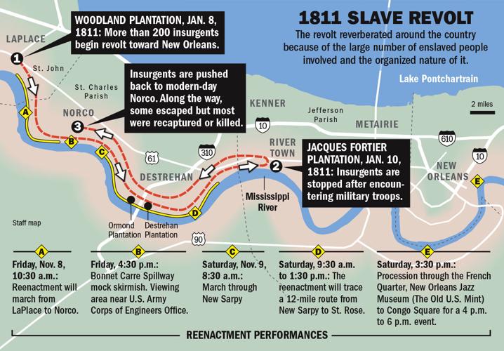
Despite what some officials in Florida want to teach, not all enslaved people appreciated the job training they were getting from their benevolent overseers. In fact there were numerous rebellions. The largest one was in 1811 outside of New Orleans.

Despite what some officials in Florida want to teach, not all enslaved people appreciated the job training they were getting from their benevolent overseers. In fact there were numerous rebellions. The largest one was in 1811 outside of New Orleans.
In response to last week's Black Atlantic post, a reader directed me to the Atlas of the Transatlantic Slave Trade. The Atlas has a companion site, Echoes: the SlaveVoyages Blog where you can browse through an impressive array of maps produced for the Atlas. Here are the major regions where captives were taken from.
 |
| via Slave Voyages |
This overview of the slave trade shows how captives were taken not just to the Americas but also to the Middle East, India and even parts of North Africa
 |
| via Slave Voyages |
 |
| via Slave Voyages |
There are many more interesting maps to discover at the Echoes site or you can buy the book here.
This map was created by Léopold Lambert to emphasize centrality of the Atlantic Ocean to the slave trade.

The map was created for an article in the Funambulist and was recently featured as a “Map of the Week” (yes there are others) for the American Geographical Society’s Ubique blog.
Though not explicitly mentioned, the ocean currents are shown and their role in the routes of the ships can be clearly seen.

The article also contains this map by Komla Eza, an artist from Togo showing the triangle trade with the “five changes of matter” in the center.

I have not been able to figure much else about this map so we’ll just enjoy it as art.

