Showing posts with label topographic. Show all posts

Wednesday, March 22, 2017

Swiss Peaks

Peaks is a visualization of Swiss mountain peaks by Raphael Schaad, a designer at the MIT Media Lab.
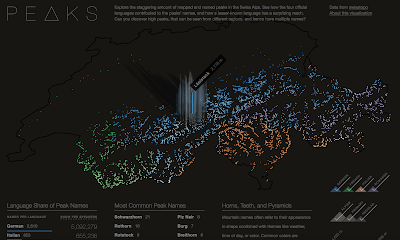
https://raphaelschaad.github.io/peaks/
He uses four colors to distinguish the language (there are four official languages in Switzerland) of each name. In addition to color (hue) he also uses lightness (value) to represent height. The highest peaks are almost white making the language more difficult to determine. As you hover over a peak, you get the name and height of each one.
There is an About this Visualization link you can click to get some insight into Raphael's design process. Here is a quote about the stories he looks to tell.
The first narrative explores the impact language has on naming (e.g. Romansh’ names have much wider reach than the region this language is spoken in), the second story shows common names (similar to almost every U.S. state having a Springfield), and the third one highlights three colors as common origins for names. Each of these narratives is also interactive and tied to the central map.
 I like way he presents the legends,
and the supplemental language details.


Wednesday, October 19, 2016

Favorite Maps-Part 3

 Swiss topographic maps have set a standard for cartographic excellence since 1838.

Since the early 1960's these maps have been based on the pioneering relief shading of Eduard Imhof.
Imhof employed the concepts of natural vision where colors of nearby objects are brighter than more distant objects. In the case of a map (from an overhead perspective) the higher elevations get the brightest colors, while the lowest elevations are a grayish blue tint. The map is illuminated obliquely from the left side and is enhanced by contour lines and rock drawings.

 The online interactive version seamlessly integrates raster information (scanned paper maps) with vectors (geodata) to the extent that it is often unclear which you are seeing. As you zoom out, the map seemlessly changes scale, while retaining its beauty.


I am also fascinated with the way they generalize features - as you zoom out buildings and other shapes simplify, merge and eventually disappear. Click below for a more legible image.
You can wander through the Swiss mountains here and/or purchase paper maps here.

Note - this is the last of the "Favorite Maps" series for now but I may have additional installments in the future.

Wednesday, March 16, 2016

The Cassini Topographic Maps

The first large-scale topographic maps based on geodetic measurements were done by the Cassini family in France. The map set (182 sheets) took over fifty years to complete and was worked on by four generations of the family between 1750 and 1815. Prints of these maps are held by the Maps Division of the New York Public Library. They very nicely let me take some out of hibernation for a look. 
 
Here is the cartouche describing the triangulated geodetic network in French. The scale is in toises-a measuring apparatus of the time, it works out to 1:86,400
Here is an image from the index map
The road network is so accurate that it can be overlaid on top of modern aerial photos. Here is another example from the northern tip of France. 
Seeing these maps in person in pretty amazing! I could stay all day photographing these but at some point I will need to move on  Here is one final picture 
Here is a link where you can browse the entire map set.