Showing posts with label kansas. Show all posts

Thursday, May 12, 2022

The Disapperance of Native American Land

Native American losses began at first contact with European settlers. "European colonization of the Americas, which began in 1492, resulted in a precipitous decline in Native American population because of new diseases, wars, ethnic cleansing, and enslavement." - via Wikipedia

Native Americans had mostly been driven out of the original thirteen colonies by the end of the American Revolution. The map below shows further land cessations between 1789 and 1816 in the "northwest" region.

via Getty Images
They were pushed even further westward into "strips of land stacked like cordwood" (quoted from Prairie Fires: The American Dreams of Laura Ingalls Wilder by Caroline Fraser p. 49). The designated Indian Territory (lands south of the Osages on the map below) was assigned to the "Five Civilized Tribes".

These tribes, the Cherokee, Chickasaw, Choctaw, Creek and Seminole were considered civilized because they had adopted Anglo-American practices such as Christianity, capitalism and in some cases the "civilized" practice of slavery. Despite being "civilized" they were still forced off their lands in the southeast and relocated westwards in the Trail of Tears.

The strip in southern Kansas was the Osage Diminished Reserve, an area left to them after signing many bad faith treaties. The rivers of their former land still bear the tribe's name.

Even after being removed from the rest of their land and granted this area of Kansas, it too became overrun with white squatters. These people included Charles Ingalls, father of Laura Ingalls Wilder. They settled on land they did not own and eventually drove the Osage out of Kansas entirely, forcing them to also relocate to Indian Territory. The tribe's base is now in northeastern Oklahoma.

Here is the full map above showing the lands assigned to "emigrant Indians" west of Arkansas and Missouri.

The Chickasaw after a long dispute paid the Choctaw for the westernmost part of their land. 

This map via Wikipedia illustrates the Trail of Tears beginning in the 1830's.

Some Cherokee had settled in northeastern Texas where they signed a treaty with Texas Republic President Sam Houston. In 1839 his successor backtracked on this treaty and sent militia to forcibly relocate them to Indian Territory. Here is a map of their final battle in Van Zandt County, via the Oklahoma Historical Society.

After the Civil War further incursions were made on Indian Territory with lands in the center of the future state ceded for potential white settlement. The western half of Indian Territory became Oklahoma Territory in 1890. Reservations in western Oklahoma were opened to white settlement leading to a series of land runs and drastically shrinking Indian Territory. Here is a map of Oklahoma and Indian Territories that year via Wikipedia. The thick red line divides the two.

Both territories sought statehood but in response to concerns from eastern politicians about creating two new western states they were combined into one state, Oklahoma, in 1907. Congress sought to dissolve the reservations as part of Oklahoma's statehood but the laws were vague and unevenly applied and has led to decades of uncertainty. In 2020 The Supreme Court of the United States, in the case of McGirt v. Oklahoma determined that much of the eastern part of the state remains Native American land. Though this case was primarily about jurisdiction of criminal cases, it has opened up questions about ownership, taxation, zoning and the enforcement of environmental policies.

A 1914 map submitted as part of the McGirt case shows the entire area that was post-1890 Indian Territory as Indian Reservations,

Image from Supreme Court Docket 18-9526 - Appendix p.33

making this by far the largest tract of Native American land in the country.

The future of this land will be determined through extensive negotiations between the tribes and state and federal authorities. For a deep dive into the Supreme Court's ruling see Indianz.com

Wednesday, June 9, 2021

The Cold War in the Heartland

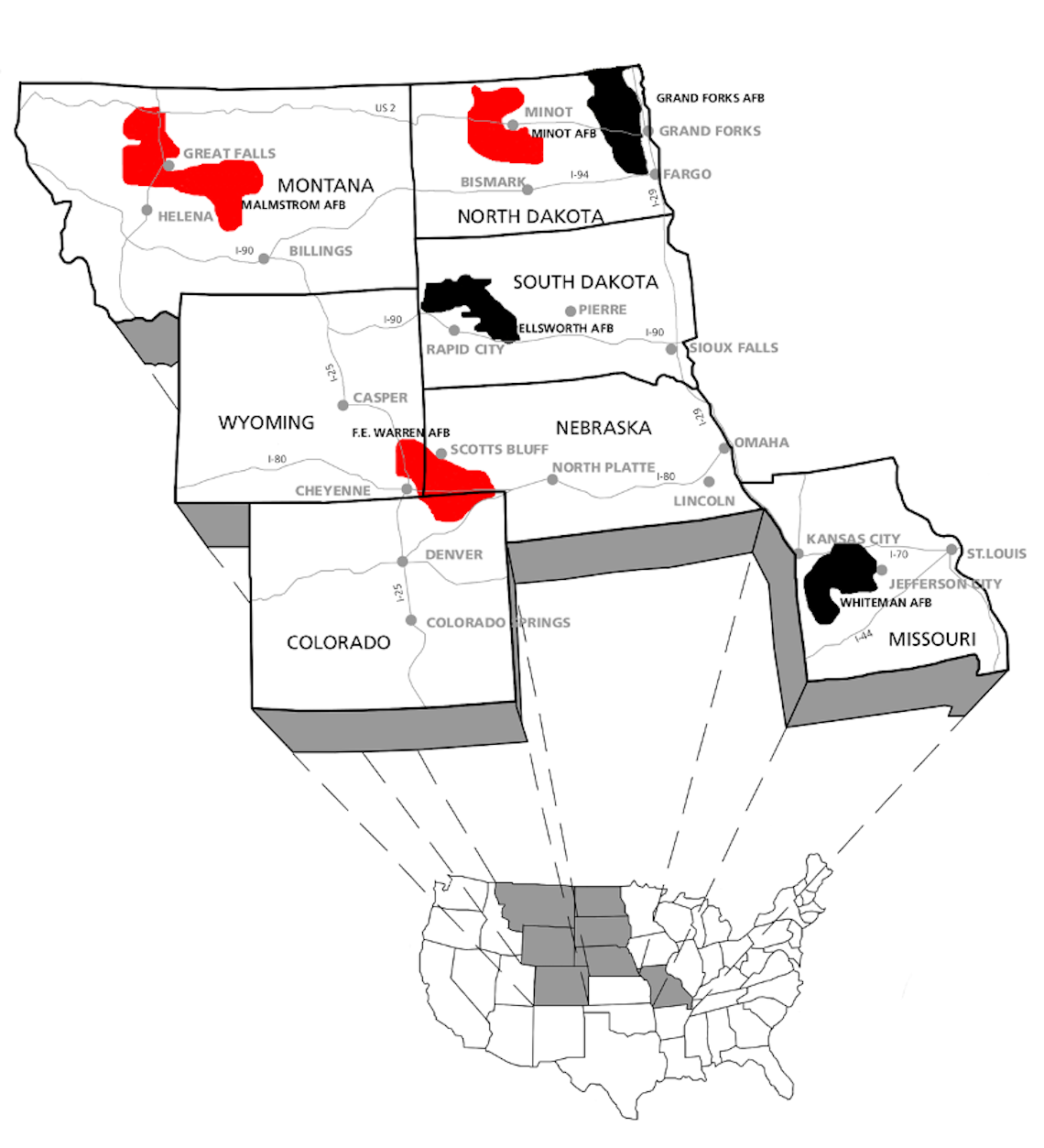
Cold War in the Heartland is a project of the University of Kansas Center for Russian, East European, and Eurasian Studies.

Durng the Cold War Intercontinental Ballistic Missile (ICBM) silos were placed throughout the United States, particularly in the upper Midwest. This map shows missile fields that are still active in red and ones that have been deactivated in black.

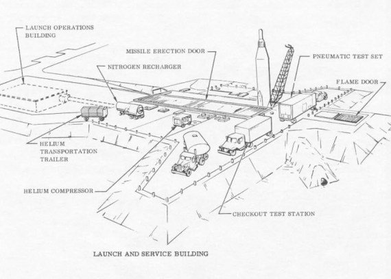
Here is a diagram of a typical missile site.

Topeka Regional Airport, formerly Forbes Air Force Base, became the home for an Air Force unit that conducted nighttime photography and mapping expeditions over Russia and other communist nations. In 1959 the Strategic Air Command ordered nine ICBM sites built surrounding the base. These were decommissioned in 1965 after the costs to maintain them became too high.

A description of the site at Worden Kansas (548-2 Lawrence) on the map above.            

"Today, weeds, bushes, and trees cover nearly the entire site and frogs cheerfully leap into the pond that has formed in front of the entry door to the old missile bay. At first glance, it appears that the site, once at the forefront of the nation’s nuclear arsenal, has been reclaimed by nature. Yet is still possible to recognize a few of the launch facility’s features, such as the different buildings and the doors that allowed the missile to be launched. These remnants speak to the profound environmental impact of the nuclear arms race, one that can still be felt today."


Tuesday, November 25, 2014

College Football Fan Map

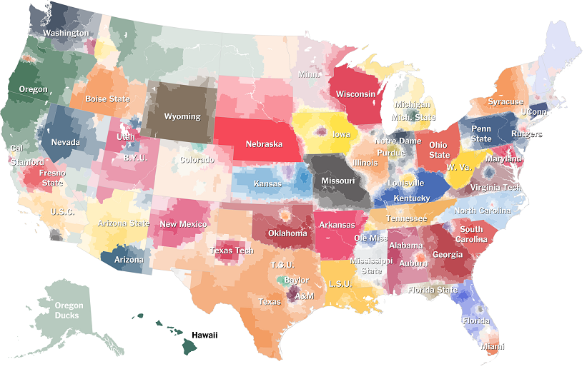
The New York Times Upshot recently added College Football to its collection of fan maps.
http://www.nytimes.com/interactive/2014/10/03/upshot/ncaa-football-fan-map.html?action=click&contentCollection=The%20Upshot&module=RelatedCoverage&region=Marginalia&pgtype=article&abt=0002&abg=1&_r=0
I like how faithful the boundaries are to the state borders. Even in Kansas where they have a reciprocal arrangement with Missouri for in state tuition and plenty of students from Missouri, the boundary is pretty precise.

Using the university colors is a nice touch but it also has the effect of overemphasizing the red schools. What really jumps out here is Nebraska, Wisconsin and Ohio State, whereas Oregon's impressive reach into California, Montana and Alaska fades info the background. The other problem with the college colors is when you have similar adjacent colors. It's especially hard to distinguish Alabama and Georgia here. South Carolina and Auburn are also in the same color family.

I also like the small pockets of fandom for the lesser state schools such as Michigan State, Kansas State, Iowa State and that little university in Virginia whose relative lack of football success has made Virginia Tech the overwhelming choice of most of that state.   

The Upshot did a related map showing where college football is the most popular.
http://www.nytimes.com/2014/11/08/upshot/the-places-in-america-where-college-football-means-the-most.html

While I'm not convinced that the Facebook "like" is the most reliable measure of our culture, it does make for an easy data set and results in a clear pattern. If this map was done in a grey scale, reversed out and overlaid on top of the first map, you'd get a picture of not only who people like but how strongly. I'd do it if I had time but work beckons.


Wednesday, January 30, 2013

The Newberry Library Part 2

This post is a continuation from last week detailing my recent visit to Chicago's Newberry Library. In the map room was a book of maps of the Oregon Trail. Having gone to graduate school in Lawrence, Kansas near the beginning of the trail, it caught my attention.

The full title is "Topographical Map of the Road From Missouri to Oregon Commencing at the Mouth of the Kansas in the Missouri River and Ending at the at the Mouth of the Wallah Wallah in the Columbia." Produced in 1846 (when the Oregon Treaty settled a boundary dispute with the U.K.) by order of the U.S. Senate, this map is from the field notes and journal of Captain John C. Fremont, and sketches and notes from his assistant Charles Preuss. There are seven sections, above is the first, easternmost section.

I like that Westport, now the place to go in Kansas City to see bands and watch drunk 20 year olds get into fights, was its own little village. Actually, it was probably a much rougher and rowdier place back then. This detailed view came from the David Rumsey Map Collection where you can see the full maps with much better clarity.

The sections feature charts of meteorological observations for sunrise, noon and sunset for each day of Fremont's expedition.These include the temperature, altitude, wind direction and brief weather descriptions such as "perfectly clear" or "occasional thunder and light."

The locations of the expedition for each day are shown on the map, along with "cyphers" listing the distance from Westport. Each section has notes in the corner that provide some good atmosphere and local color. These are from section 1:
This section abounds with grass, water and fuel so that emigrants may encamp almost anywhere.
Elk and deer, the only game, are very scarce.
Selected notes from the other sections provide lessons in geography and attitudes towards non-whites.
Game - Antelope and Buffalo, the latter in innumerable bands.

Timber is extremely scarce, except on the islands*. Some driftwood and buffalo excrement makes the fuel as that of the camels does in the deserts of Arabia.

Good guard ought to be kept. Pawnees, if they do not kill, will at least take what they can from the travellers [sic] by force if they are strong enough, and by stealth if too weak to act openly.

With this section** the prairie ends, and the barren sage (artemisia) country begins.

East and West of this section [section 3] more or less buffalo and antelopes, but 50 miles from Fort Laramie each way no game is to be found. Grass - is scanty and only occures [sic] on the banks of the rivers and creeks.

At Sweetwater River*** buffalo appear for the last time and emigrants should provide themselves with well dryed meat.

West of the Green River the traveller [sic] is considered out of danger, as the Snake Indians are considered friends of the whites. Property however should be guarded.

This is the most trying section**** for the traveller on the whole route. Water, though good and plenty is difficult to reach, as the river is hemmed in by high and vertical rocks and many of the by-streams are without water in the dry season. Grass is only to be found at the marked camping places and barely sufficient to keep strong animals from starvation. Game there is none. The road is very rough by volcanic rocks detrimental to wagons and carts. In sage bushes consists the only Fuel. Lucky that by all these hardships the traveller is not harassed by the Indians, who are peacable [sic] and harmless.
Of course, these notes also provided highly valuable information for emigrants heading west.
 
*     the islands of the Platte River
**   section 2 covering the area between 98 and 102 degrees west longitude along the Platte River. 
***  near the continental divide
**** section 6-along the Snake River between Fort Hall (north of Pocatello)  and Fort Boise in Idaho.


Wednesday, December 12, 2012

12/12/12

Happy 12/12/12!


 Here are some maps and boring facts about highways designated as Route 12 - mostly from Wikipedia.

US Interstate 12 is one of the shortest major (one or two digit) interstates in the country running 85 miles along the north shore of Lake Pontchartrain all in Louisiana. It is a shortcut that takes you from Interstate 10 back to Interstate 10 avoiding New Orleans. The road is also officially called the Republic of West Florida Parkway, in honor of that short lived republic created from an 1810 rebellion against Spanish rule.


By contrast US Route 12 is an almost cross country route running from Detroit to Aberdeen, Washington, almost 2,500 miles. The photo on the lower left was taken near the intersection of Michigan Avenue and Cass, where Route 12 officially begins. This photo came from the US Ends, a web site for people like me who are obsessed with where roads begin and end. On the left is a map of the Grays Harbor area at the western end of Route 12.


South Korea's Expressway Number 12 is also called the 88 Olympic Expressway. It runs across the southern part of the country.


There's many other highway 12's listed on Wikipedia's List of highways numbered 12 inlcuding the following three non-US routes chosen because I like their route shields.


Finally realizing that I forgot the awesome Kansas sunflower route shields (despite K-12 being retired,) here is another set of US state route shields. Once again, Happy 12/12/12!

Wednesday, February 23, 2011

What I Did for a Living

When I was a graduate student at the University of Kansas in 1992, I was offered a job producing a map for disabled students. I recently discovered that this map is still actively used on KU's website.


I remember spending 13 hours uncompressing the original CAD drawing from Facilities Management to a useable format. Back then there were no status bars to tell you how long it would be or if it was even working. Just 13 hours of waiting and hoping something was actually happening. I converted the file to an eps format and brought it into Free Hand - a product that appears to be going out of use.

The map uses blue (I think they've darkened it a bit) to indicate the accessible buildings because it's the color of the handicapped signs as well as the color of the Kansas Jayhawk's uniforms. It's not the best color for sending a clear message but it basically works. The blue arrows point to the accessible entrances. My (misspelled) name appears in the credits at the bottom of the page.*

*Update (December, 2013) - They changed the web page. I no longer see my misspelled name but I'm surprised that they're still using it rather than some googly thing.


Tuesday, October 5, 2010

What is Map of the Week?

Today is the fifth anniversary of Map of the Week! Sort of. Actually it's more complicated than that as most things are. An exact anniversary date is tough to pin down so today is as good as any. Here's the boring history lesson:

Map of the Week started in or around 1993 when I shared a house in Lawrence, Kansas with fellow graduate student, frequent commenter and Renaissance blogger Michael5000. We started putting maps of the week on the kitchen wall (or maybe fridge I can't remember everything from those crazy college days.)  They were not exotic or special - just maps that we felt like posting and the practice didn't stick for very long because we had homework and life to attend to.

When I accepted a job in Seattle, a place I'd never been, I drew this mental map based on my limited knowledge and probably posted it as a final map of the week. The map suffers from the classic "figure ground" problem-the water looks like land and vice versa. The original is on yellow paper, printed on the back of a lost dog notice.


On occasion I would send Mr. 5000 maps in the US mail that I found to be noteworthy. Here is a map from a charity newsletter of a project they did in Moncton, New Brunswick. I clipped out the charity's name to spare them the embarrassment as they do some very good work.


The map is pretty tough to read from my poor copy but basically they didn't know where Moncton or New Brunswick were so they just plopped it right in the middle of the country. That's OK - Canada's a small place!

Years later (around 2004 or so) I decided to revive Map of the Week as a weekly e-mail with a map attached. Five years ago today I started keeping track of what map I posted on what date with an eye towards a possible blog. I finally created the blog in 2007 and began by back posting all my entries beginning October 5th, 2005. As of today the blog has reached over 150 countries!

Map of the Week will try to continue to bring a quality blog product every week, with the occasional extra map of the weekend or other special event. Map of the Week will not advertise your book, or map products but if something looks interesting, I may post it without the sales pitch. Thanks to all my readers for years of support!