Showing posts with label florida. Show all posts

Wednesday, August 1, 2018

Pirates of the South Atlantic

This map is from imgur. Like so many things on that site, there are no credits. I like the exaggerated rivers and goofily drawn state boundaries.
[Map] Pirates of the South Atlantic and their flags

Wednesday, February 14, 2018

Look North

Going through my recently acquired road maps, I was intrigued by the many different north arrows. Many are gas stations maps-the work contracted out to map publishing companies such as Rand McNally and H.M. Gousha. Oil companies put their names on the map and often their logo on the north arrow.
Here's an example from the Gulf "Richmond Tourgide" - their cutesy misspelling, not mine. Rand McNally produced this map. Here are some more:


Flying A Service Metro D.C. Street Map- Gousha.


Cities Service - I don't know who they were and it was hard to get a clear picture of their logo. This is from their Maine map (Bangor inset). You can see the H. M. G. Co. (Gousha) text.


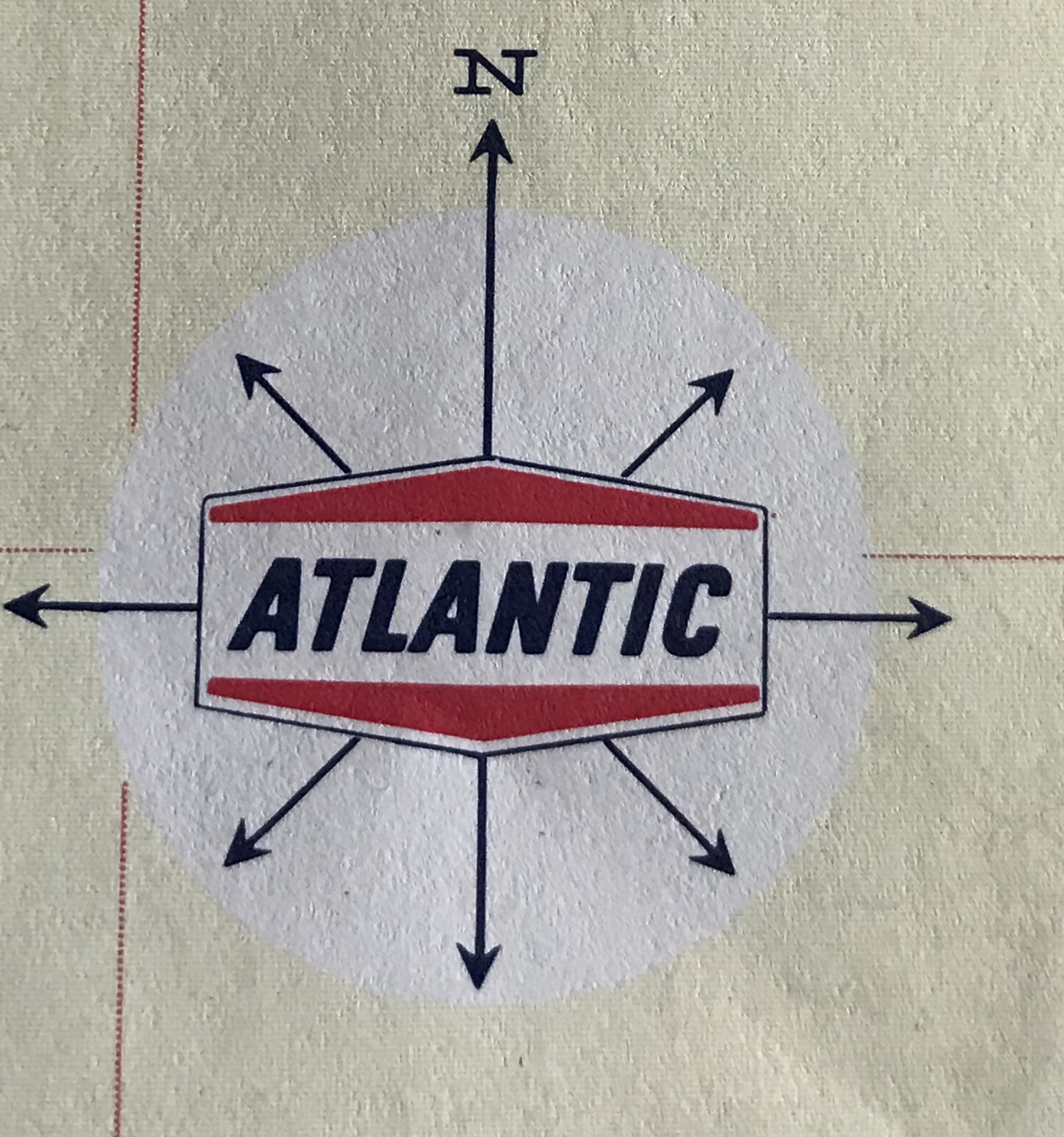
Before Arco, there was Atlantic - From a Tampa-St Petersburg map-Rand McNally


American - Greater Miami Street Map and Mobil Travel Map of the San Fernando Valley, California - Rand McNally


Two Gousha's - one from the Hertz/American Express Chicago map and one from their own branded New Orleans city map.


AAA's maps used this globe north arrow. They liked to put them in the water.


Here is one from Rand McNally's Los Angeles map. It appears on the LAX airport inset. This map looks very different stylistically from the rest of the map and the Thomas Brothers north arrow explains why.

The other sections of the map all have this dull, understated e.e. cummings- style "n"


Some state tourist agencies.
Maryland - I don't love Maryland's schizophrenic flag, but I like how they incorporated it into their north arrow.


Virginia - very detailed.


Montana-now that's a quality north arrow!


Best of all - South Dakota with its compass ring showing where the needle would point at the center of the state. Two rings, one for true distance and one for magnetic variation, plus the state seal!
 Here are some more


Wednesday, September 13, 2017

Hurricane Footage from Snap Map

I don't spend much time with social media. As a result, I've been missing one of the bigger map stories of the year, the growth of Snapchat's Snap Map. Hurricanes Harvey and Irma have brought Snapchat to the forefront of media coverage. 
Image via Elite Daily
According to Elite Daily, when Irma made landfall Snapchat received 250,000 submissions within 24 hours. These numbers are way higher than the already high 100,000 daily submissions from Hurricane Harvey. Major media outlets used these pictures and videos in their coverage. The map part of the app is useful to focus on what is happening in specific geographic areas.
Image via Recode
The yellow-red colors in the background show where larger concentrations of posts are geotagged. Zoom in to see more Snapchat pictures and videos. Here's an example via Recode.
Early previews of the mapping function focused on it as a fun way to send your private data to corporations.
http://www.refinery29.com/2017/06/160114/how-to-use-snapchat-snap-map-update#slide-6
Having fun at the club!!!
It's somewhat ironic then that it has become a way to voyeuristically watch people's lives get torn apart by natural disasters.

NOTE: I tried to get Snapchat on my old phone so I could see for myself and get my own images for this post. Unfortunately I do not have enough storage on my phone to download the app. Sorry that I have to rely on second hand images like the ones above instead of providing original content.

Wednesday, April 30, 2014

40 Maps That Won't Explain Anything - Part 2

Here's the second installment of 40 Maps That Won't Explain Anything - Part 1 with a snarky explanation about this series is here.

11. Hand painted map of submarine fiber optic cables. A zoomable version is here.
12. James Niehues makes pretty ski area maps. Here's Mt Alyeska in Alaska with the aurora borealis lighting up the sky.
13. Upside down 1963 Esso map for travelers going from New York to Florida.
http://imgur.com/RmpTTom
14. "Eastern Shore of Virginia - Most Fertile Trucking Area in the United States" G.L. Webster Canning Co.
http://www.lva.virginia.gov/public/archivesmonth/2005/vhs/VHS_8.htm

15. Map of San Seriffe - from a Guardian April fool's prank.
http://www.theguardian.com/news/datablog/2012/apr/01/guardian-april-fools-list#zoomed-picture
16. Majority Home Heating Fuel Type - Washington. From the American Community Survey.
17. TweetMap - heat map showing where people were tweeting using the hashtag #Phillies last summer.
18. The Tacony Hoagie Trail in Northeast Philadelphia. Go for a healthy hike!
https://mapsengine.google.com/map/edit?mid=zhjjli_rr4GQ.kAhU8P0PgLN4
19. The Japan Railways System
20. 1915 stamp featuring a map of Mexico


Friday, February 24, 2012

Spying on Those You Care About

My wife is flying through thunderstorms from Philadelphia to Fort Myers, Florida. I just got a free iPhone app called "Flight Aware" so I can see where she is. You can also see the thunderstorms moving out to sea.


I can also see what kind of air traffic she'll be up against in the area.


And take look at the airport area to see how much more traveling she needs to do from the airport. This is almost as cool as Passur's live airport monitors!


UPDATE - she made it! Thank you airline industry!

Thursday, July 3, 2008

Map of the Week-Happy Birthday USA!

In honor of July 4th, I've been looking at Uncyclopedia, a mostly stupid but amusing Wikipedia farce, for some fun maps of the US. So in the spirit of dumb holiday fun here is how the rest of the world sees us:

And this is the world according to us (or US):


And just because I like this picture, here is what they consider a typical road sign you'd find on Interstate 4 in Florida.

Thursday, February 2, 2006