Joan Blaeu produced a remarkable 11 volume atlas between 1662 and 1665. It was the largest book published during the 17th Century.
 These volumes were meant to be the first part of a larger series. The title translates to "Grand Atlas or Blaeu's Cosmography, in which are most accurately described earth, sea, and heaven" with a second part about the oceans and a third about the stars. However, he did not live long enough to publish those volumes.
This summer I went to the Osher Map Library in Portland, Maine to see their Pictorial Maps exhibit (see my previous blog post for a review.) The first map in the exhibit though not "American" or part of the "Golden Age" was from this atlas and meant to show an early use of pictorial decorations on maps.
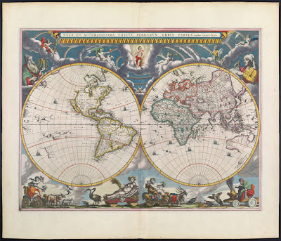 While I was there, they let me look at a volume of this atlas. I chose the first volume and took pictures of various pages, including the map above (though the image from Osher shown above is much better than my photo.) It was an amazing experience to hold a volume of this atlas in my hands. Unfortunately between the lousy notes I took and my lack of knowledge of Latin, I don't have much to add to the photos I took - here they are.
 From the Introduction - the orbit of the known planets, going out as far as Saturn.
 The first volume is mostly focused on the Arctic regions. Above is the island of Spitsbergen, below is the adjacent island of Jan Mayen with some great (and probably very exaggerated) details.
 More easily recognizable to most people, Iceland.
 In addition to maps, the atlas has some great pictorial details including this Walrus illustration,
 and whatever this totem is. If I could read Latin, I might be able to figure it out. Note: see comments for a good explanation.
 There are also details of buildings and other public and religious spaces. Again, I don't know what we're looking at here.
 UPDATE: Reader Ted Kottler has identified this as Tycho Brahe's observatory on the island of Hven (aka Ven), Sweden in the Oresund, the strait between Sweden and Denmark.
I'll finish up with one more map. After much curiosity and digging around, I figured out that the map below is part of the Nordfriesland district in Schleswig-Holstein, northern Germany along the border with Denmark. I'm still not sure what the underwater streams are - some elaborate planned land reclamation, ocean drainage project?
 Once again, I would like to thank the kind and helpful staff at the Osher Map Library for allowing me to see and hold this atlas. Though the pictorial map exhibit is over, there are still lots of great things to see there.

This summer I went to the Osher Map Library in Portland, Maine to see their Pictorial Maps exhibit (see my previous blog post for a review.) The first map in the exhibit though not "American" or part of the "Golden Age" was from this atlas and meant to show an early use of pictorial decorations on maps.


I'll finish up with one more map. After much curiosity and digging around, I figured out that the map below is part of the Nordfriesland district in Schleswig-Holstein, northern Germany along the border with Denmark. I'm still not sure what the underwater streams are - some elaborate planned land reclamation, ocean drainage project?