Showing posts with label history. Show all posts

Thursday, June 11, 2026

The Mysterious "Frenchman's Map" of Williamsburg

While visiting family in Virginia this week, we made a trip to Colonial Williamsburg (CW), a good place to go during the 250th anniversary of the United States. While there I came across a cartographic mystery. The “Frenchman’s Map” was said to be instrumental in the restoration of the colonial village. The black and white version above is from Wikimedia commons. 


Here is a piece of a colorized version of the map that is for sale at the CW bookstore. 

There is a lot of detail but very little explanatory text, leading many to believe that this is merely a draft version with the final version yet undiscovered. This and the following conjectures are largely from In Search of the Frenchman’s Map, as well as the book The Mysteries of the “Frenchman’s Map” of Williamsburg, Virginia by Alan Simpson. Yes, there is an entire book dedicated to this map! It is speculated that the map was drawn for French troops who set up their winter quarters in Williamsburg in 1781-82. The map is similar to ones of nearby Yorktown and Hampton drawn by the Berthier brothers of France, but those maps are more complete. It is also likely that it was traced from another version given a series of pinholes in it. 

It is also a mystery as to who the “Frenchman” was. There is no signature on the map and the caption is not in the same handwriting as the rest of the text. Finally, the date on the caption is May 11, 1782, which would have been well after it was needed. 

While visiting the engravers shop in the village, I saw a tray she had been working on with the map etched into it. 
The map has some remarkable details, though described as “impressionistic“ in the article referenced above. It shows building outlines, fences and in some cases even indicating specific trees with dots. Here is the map followed by a detail from the tray’s engraving. 

The folded paper map they hand out to visitors has many nice details too and the building coloring is useful. This is most of the map, trimmed to fit the page better. You can see entire map and guide here. 
By contrast here’s the Frenchman’s version. 
The article on the CW site (the first one listed above) is an interesting short read. It goes into a lot more depth about these mysteries including details of how it was obtained after being lost for a century.

Wednesday, January 7, 2026

Overlooked Mapping Highlights from 2025-Part 2

Here are some more mapping highlights from the last year:

 5. Silk World War II escape maps

This is from an episode of a podcast called What’s Your Map featuring former cartographic researcher in the UK Ministry of Defence Barbara Bond

Top secret British intelligence agency the MI9 produced a series of maps on silk (and later rayon) designed to help soldiers evade or escape from capture. This map is of Danzig (Gdansk), where the Vistula River enters the Baltic Sea.


Escapees used their knowledge of these areas to direct others to Swedish ships where they would be safe to escape to that neutral country. Maps were printed on fabrics such as silk, which could be stitched into clothing or kept in a pocket and did not make any noise when folding or unfolding them. The maps showed where coal is loaded onto Swedish ships, the arc of light to be avoided, ditches where people could hide and the network of railroad tracks that would need to be traversed. More on these maps and on Bond’s career can be heard on the podcast.

6.  Mapping the Wikipedia Rabbit Hole

WhereWiki allows the user to enter any Wikipedia page and see all of its hyperlinked connections in any given area. When I first saw this, the keyboard player for the Cure had just died so I chose the band’s page and the area around Crawley, UK* where they were formed.


A click on any point brings you to the referenced page. The green dots are locations and the blue are people or groups.


*You can choose the default area (where you are now) or just about any other place on earth and you will likely find plenty of geographic links to whatever page you chose. 

-via Maps Mania


7. Smell Map of the Minnesota State Fair

Jake Steinberg, a cartographer and journalist for the Minnesota Star Tribune created a map of the smells of the State Fair. You can see the full map and article here but you might hit their paywall


8. Inundation Map of the Town of Guadalupe (1819)

Guadalupe, now part of Mexico City suffered a major flood in 1819. The entire area was in the basin of former Lake Texcoco and floods were a frequent occurrence


-Maps via Pedro Zurita Zaragoza on that great mapping site known as LinkedIn.

The map shows inundated areas in aqua tones. Two waterfalls shown at the bottom are breaches of the Guadalupe River.


Text in the legend describes how canoes were needed in the plaza and a note at the bottom states that the floodwaters receded “by virtue of the wise measures of His Excellency (the viceroy), thus preventing its spread to the capital.” Plans to drain the area took almost a century after this to be implemented and this was largely responsible for drying the entire region.

9. 12 Foot Wool Map Needs a New Home

 A group of up to 18 women in County Wicklow began making a 12 x11 foot knitted and crocheted map of Ireland in 2019. 


As reported by The Journal (Ireland). Most of the project took place at Carnew Community Care, a centre for older people. Now that it is finished they are looking for a place where it can be publicly displayed. This was from July. I have not been able to find any follow up on whether they’ve found a location for it.


 -via The Map Room


Wednesday, June 25, 2025

In 1977, the Kinney Shoe Corporation, in cooperation with the President’s Council on Physical Fitness put out a series of walking tour brochures for historical sites across the United States. Perhaps the idea was, walk more, wear down your shoes and buy some more.

Here is an example from Paterson, New Jersey, “America’s first great industrial city”. Alexander Hamilton saw the power potential of the Great Falls of the Passaic River, the second largest waterfall east of the Mississippi River.

The walks range from rustic, historic ambles (I chose this one for both personal history and because it’s near where I’m writing this from),

 to college towns,

 to downtown tours,

 museum and garden loops,

and finally to a “redwood grove near Santa Cruz”.

Along the way, you learn about the ghosts of F. Scott Fitzgerald, Thomas Mann and John O'Hara haunting the libraries and tap rooms of Princeton, Chicago's architecture, the friendliness of Woodstock, Illinois, miscellaneous redwood facts and that Scottsdale, Arizona has some of the "prettiest women".
 

Wednesday, February 19, 2025

Mapping Prejudice

Mapping Prejudice is a project by a team of scholars and activists at the University of Minnesota. The project maps racial covenants, clauses that were inserted into property deeds to keep people who were not White from buying or occupying homes. 

The mapping page has an animation that show the growth of these covenants in the Minneapolis-St. Paul metropolitan area from 4 in 1910 to over 32,000 in 1963.

Or you can see all of them with their details. The green color does not stand out great again the gray background though.

There are also some static maps showing racial covenants in the area. This one does a good job of showing how they cluster around the Minneapolis city boundaries.

This is an ongoing process and you can volunteer to help find racial covenants in deeds and participate in community mapping sessions.


Wednesday, June 19, 2024

Emancipation National Historic Trail

It took over two years for the Emancipation Proclamation to reach Galveston, Texas. Specifically June 19, 1965 hence the Juneteenth holiday. Galveston was the largest slave market west of New Orleans. The newly emancipated fled Galveston to Freedmen's Town and other parts of Houston that had large African American communities.

via Texas Highways
In 2019 the US House of Representatives passed the Emancipation National Historic Trail Act. This act would create the second National Historic Trail centered on the African American experience, after the Selma to Montgomery trail in Alabama. The map above traces the approximate route of this trail.


Wednesday, February 22, 2023

The Spread of Slavery in the United States

In September, 1861 the U.S. Coast Survey published this large map showing the enslaved population by county. It was "sold for the benefit of the sick and wounded soldiers of the U.S. Army."

The image above is from an article in Smithsonian. Here is a detailed view showing part of the Carolinas with the county names and enslaved populations.

The articles' author, Lincoln Mullen created a series of animations.

On his own page are some interactive maps where you can choose variables such as free African Americans and total population and choose your year from a slider at the bottom. This allows you to see the high slavery numbers in 1790 in places like eastern New York and Northern New Jersey.

Or see where free African Americans were clustered in different years.

Here is one showing all free persons by percentage from 1810.

You can explore on your own here and read more about the westward expansion of slavery here.

Wednesday, July 6, 2022

Northern Expansion

I've seen plenty of map like this one, showing some ridiculous looking westward claims of US states and colonies before that.

via Library of Congress
If ridiculous seems like a strong word, just look at that South Carolina panhandle! What I've never seen before is this circa 1754 map showing some huge land claims to the north.
Sidney R. Knafel Map Collection/Leventhal Center
There is not much information about this map other than a simple title "An accurate map of the English colonies in North America, bordering on the river Ohio", and that it appeared in the Universal magazine of knowledge and pleasure. It's interesting to see New Jersey and Pennsylvania grabbing land in upstate New York, Maryland claiming much of Ohio, and Virginia reaching up towards Michigan. In some ways this makes sense given the north-northwesterly flows of the major rivers these colonies formed along, the Hudson, Delaware and Potomac.

I don't know anything else about this map or these claims but it's always interesting to see a different perspective on history.

Wednesday, June 8, 2022

Book Review-Make Me a Map of the Valley

Here is a review of a book you probably weren't planning to read: Make Me a Map of the Valley: The Civil War Journal of Stonewall Jackson's Topographer

Jedediah Hotchkiss was a brilliant cartographer who worked for Thomas "Stonewall" Jackson and other Confederate generals after Jackson's death. Originally from upstate New York, he settled in Virginia and became a loyal soldier of the Confederacy.

I bought this book after reading about it in an online forum. I was under the impression that I would get some insight into 19th Century cartographic practices. Disappointingly, there is no discussion of how the maps were produced, just "Worked on a map of {such and such} County", the occasional mention of "map reduction" and his need for materials, mostly just paper.

As a northerner, I must put aside my biases and acccept the U.S. Army being referred to as "the enemy". His religious sanctimony and hypocritical complaints about the government taking away the freedoms of people who own slaves are also annoying, but to give this book a fair review, that is all I will say about it. 

There are several examples of his maps at the end of the book. To avoid copyright issues, here is an example from the West Virginia Encyclopedia. There's some state name confusion as West Virginia was a brand new state and many locations were still referred to as "Virginia" as in the map below. I suspect the color was added later. The maps in the book are in black and white.

Unfortunately the example maps from the book are provided without context and in most cases they are very hard to place within his journal passages. Many of the maps are of battles that are not even mentioned.

Hotchkiss kept a massive journal covering most of his adult life. This book only covers his military service during the war, from March, 1862 to April, 1865. The passages are very dry and hard to read. There is a lot of name and place name dropping, usually devoid of the context that would make it interesting, or at least understandable. Here is a typical passage:

"Wednesday, Dec. 3rd [1862]. Travelled by the Plank Road, towards Fredericksburg, turned off just below Verdiersville and taking the Catharpen Road through an almost unbroken forest. Went to within 6 miles of Spotsylvania C.H. A Mr. Davis, of Rockbridge Co. was with me: we got a good dinner at Mr. Wright's; found Charles Harris of the Q.M. Dept. where we spent the night. The roads are badly cut up. The day was fine; sunshiny and pleasant. Hd. Qrs. at Guiney's, at Mr. Chandler's"

Major battles such as Antietam and Gettysburg are mentioned but without much indication of the importance of these events. In his defense, it is hard to know in the middle of a war, what will become the major events of a war. Also Hotchkiss takes on a kind of cheerleader role in his journal by talking up the "routs" and captures of the enemy. There is little indication that his side is losing the war until the last few pages. The footnotes even mention that his letters to his wife reveal a much more despondent tone on the progress of the war.

The most interesting parts of the book are the Foreword and Introduction (there is also a Preface). The foreword discusses how both sides lacked maps of the area where most of the fighting took place. Most of the battles were in rural locations that were off the main transport routes. The Introduction, written by historian Archie P. McDonald, covers the events of that period. Detached from the day to day details, it provides the overall context that is missing from the journal entries. I re-read it after finishing the journal part to make sense of what I had just read.

The key event is when General Jackson asked Hotchkiss to "make me a map of the Valley, from Harper's Ferry to Lexington. showing all the points of offence and defence in those places...." This huge 100-inch long map of the Shenandoah Valley is considered his masterpiece. 

It would have been helpful to have included at least part of this map in the end papers, though maybe technically difficult to do for such a large map. Many of the obscure locations referenced in his journals can be seen here. The full map above can be seen via the Library of Congress web site. You can see much more of his work from LOC's Hotchkiss Map Collection.

Wednesday, April 13, 2022

Maury's Wind & Current Charts

U.S. Naval Officer Matthew Fontaine Maury developed wind and current charts starting in the 1840's. They helped save shipping companies millions of dollars and avoid losses of life and cargo by giving sailors critical information about wind and current patterns. 

Wind & Current Chart of the North Atlantic-via American Geographical Society Library

Detail off the coast of Tampico, Mexico
As director of charts for the Navy, Maury had access to decades of ships' logs. These logs included routes and weather conditions. During the California gold rush these charts helped shorten the trip from New York to San Francisco by 40 days or more. 

The length of the arrows denotes the strength of the current. Colors indicate the season of each track. The dots represent wind speed as indicated in the legend below.

Here is a detail of the mouth of the Rio De La Plata from one of his South Atlantic charts.
via Yale University Library

Maury went on to map the Pacific and Indian Oceans, monsoon patterns, ranges of the sperm whale and discovered an undersea plateau that could be used for laying the first transatlantic cable. More on his life can be seen in this PBS American Experience article.

Wednesday, March 30, 2022

Women's Suffrage in 1917

As a follow up to Women's Suffrage in 1908, here is an ad from 1917 showing how suffrage (the white areas*) had expanded through most of Canada and parts of the United States. 

The ad is from the National Women's Suffrage Publishing Company and asks how long the U.S. will lag behind Canada. For contrast here is the 1908 map again. Keep in mind that the color scheme is reversed.


*yes the white areas are actually sepia areas, OK.

Tuesday, March 8, 2022

Women's Suffrage in 1908

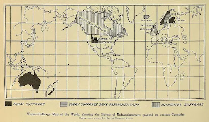
This map shows the international state of women's suffrage in 1908. It was originally published in Harper's Magazine and reprinted at ThoughtCo.

Full equal suffrage existed only in Australia, New Zealand, Norway, Finland and a handful of poorly drawn northwestern U.S. states. Finland also allowed women to run for Parliament. The "Municipal Suffrage" of Canada and Iceland meant women could only vote in local elections. The U.K. and Sweden vote in non-parliamentary elections.

This Wikipedia page gives more details. The page also mentions Latvia though not shown on the map. In many cases the right to vote was restricted for a time to married or property owning women. In Australia indigenous women were excluded from voting. It looks like Kansas is shaded in light gray though the Wikipedia page has that state granting women the right in 1912. Maybe it was being considered at the time. There was a gradual trickle of states between 1908 and 1920 when finally women were allowed to vote nationwide in the USA by the Nineteenth Amendment.

Wednesday, February 23, 2022

Al-Khwārizmī's Geography

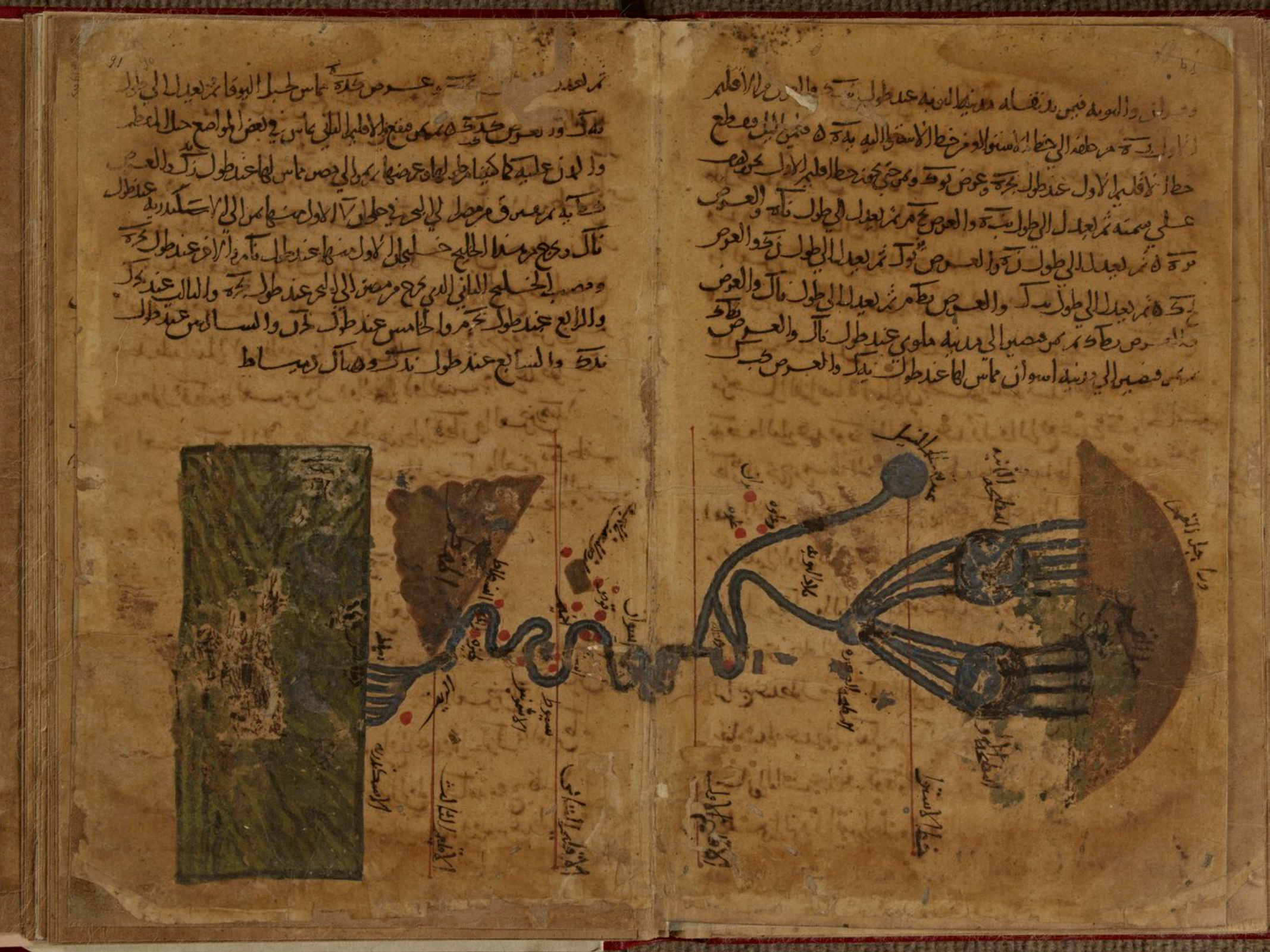
Persian polymath Muḥammad ibn Mūsā al-Khwārizmī (c. 780-c. 850) had a huge influence on the development of algebra, the Hindu-Arabic numeral system, astronomy and cartography. His Kitāb Ṣūrat al-Arḍ (description of the Earth) was a major reworking of Ptolemy's Geography correcting much of his data for The Mediterranean Sea, Africa and Asia. Here is the earliest known map of the Nile River from that work,

some nice details of the origins and branches of the river, 

and the delta where it meets the Mediterranean.

The only surviving copy of this book is in the Strasbourg University Library in France. The copy is in bad shape and parts are almost illegible. Though latitudes and longitudes of thousands of places appear the world map is missing. Historian Hubert Daunicht reconstructed this map, the only copy I can find is this low resolution version from Wikipedia, showing the Indian Ocean.

For fans of "World Music" a band called Guess What named an album Al-Khawarizmi (with a slight spelling difference). The cover includes an early Islamic world map in the lower corner.

A previous post on this blog has a partial explanation of some of the elements of this map.