Showing posts with label maps in unexpected places. Show all posts

Wednesday, July 10, 2013

Grape Crate Map

My mother in law has a mounted copy of this vintage grape crate label in her cabin in Naples, New York.
Naples (at the bottom of Canandaigua Lake) is in the heart of the Finger Lakes wine country. There is no date listed but the label is from around 1900 and according to the Antique Label Company "was lithographed during a time when lead, cobalt and other compounds were often introduced as a part of the ink used to make the images brilliant, vivid and colorful."

Wednesday, September 5, 2012

Makeup a State

I am currently on vacation so while there's probably lots of important things happening in the world, here are some images of makeup compacts. This is not an item I buy many of but here are two for sale online featuring state maps!
Utah:


 Available from e-bay for $35. There's a zoom viewer on e-bay's page.

Hawaii (not to scale):

This one was on Etsy for a mere $15 - and it features a "scattering of tropical fish." Unfortunately it's been sold. The page is still up and shows more pictures.

Wednesday, August 29, 2012

A Mappy Day at the U-Haul Store

A couple of years ago I had a post about maps on U-Haul trucks. Today I had to go to the U-Haul store. While there I saw some more nice trucks.

This Missouri truck features the bats of Onondaga Cave State Park. From close up the bat at the top looks like its hanging right off the truck. I like the gratuitous highway details around St. Louis. The full graphic can be seen here.
The Alaska truck shows a large goshawk. The close up view reveals some nice relief detail of the Tongass National Forest.
Iowa's truck features the Manson Impact Crater. This crater is 24 miles in diameter and is believed to be caused by a meteor's impact 74 million years ago.
 Off goes the Missouri bat-mobile on a mission!
In the interest of full disclosure this was actually taken on a different day in a different location.

Friday, July 22, 2011

Map of the Weekend-Sweet Mappy Dreams

The best way to end a Detroit map week is to fall asleep on a nice Detroit River Pillow from the SaltLabs.


Or you can choose from a range of other nice designs. Sweet Dreams!


Wednesday, April 20, 2011

Maps in Unexpected Places-Savannah Part 2

As promised here is part 2 of the Savannah edition of Maps in Unexpected Places.
Vic's on the River is a restaurant in an old warehouse, that was used by General Sherman's officers as a planning space. The main dining room showcases a map drawn by Union soldiers in the Civil War detailing Sherman's march from Tennessee through Georgia. The map was discovered during a renovation drawn onto the wall. For protection, it is framed under glass. The romantic dining lighting is poor for photography but here are some pictures I attempted. I can't find any good images of this map online so these photos are the best I have. First, the explanatory text.


The northern part of the map shows Chattanooga, Lookout Mountain, and the Georgia, Tennessee border region.


Lookout Mountain.


Some details a little further east. 


Oh and by the way, the food is excellent, too. Come for the map, stay for dinner.

Thursday, March 31, 2011

Maps in Unexpected Places-Savannah Part 1

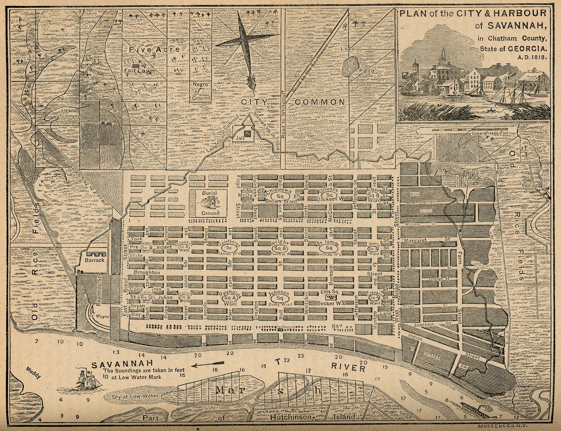
We just got back from a trip to Savannah, Georgia and saw a few interesting maps in unexpected places. This map, the first of two that I plan to spotlight, is embossed on both awnings of the new Sylvester & Co. Modern General store on Broughton Street downtown.


Here is a close up of one of the awnings. The black on gold is very striking and closely reflects the original map colors.


The map is titled "Plan of the City & Harbour of Savannah, in Chatham County. State of Georgia. A.D. 1818." It is from the "Report on the Social Statistics of Cities," compiled by George E. Waring, Jr., United States. Census Office, Part II, 1886. The map can be found online at the Perry-Castenada Library Map Collection at the University of Texas. Click below for a detailed view.


Savannah was founded in 1733 by General James Oglethorpe, who laid the city with six squares. As the city expanded more squares were added at regular intervals until there were 24. 22 of these squares still exist today in a National Historic Landmark District. These squares give the city a unique feel and charm. Major historic preservation and landscaping efforts protect the scenic and inviting character of the district.

This map, from 1818 shows the first 15 squares, with the area south of Liberty Street still undeveloped and listed as the "City Common." An empty space is cleared for Crawford Square, which sits on a "line of defense thrown up in 1814"  along the perimeter of the city.

Map 2 from Savannah will be featured in an upcoming post.


Wednesday, July 14, 2010

Maps in Unexpected Places-Restaurants

I love ethinc restaurants-especially ones with nice maps on the walls. Here are some examples taken from my iPhone:

A portion of a map of the Middle East from the Athena Restaurant in Glenside, Pennsylvania.


At Punjab in Arlington, Massachusetts - a map of...Punjab!


Los Paisanos, a Salvadoran place in Somerville, Mass. has this clocklike wall display showing the currency and provinces of El Salvador.


Here is a close up of the map part.


 Even the napkin holder has a map of sorts.

Thursday, January 21, 2010

Maps in Unexpected Places - Part 1

This is the first of an occasional series highlighting maps in, you know, unexpected places. I saw this map of the Underground Railroad on a U-Haul truck this morning.


You can see all the states and Canadian provinces at U-Haul's online super graphics page.

Other map oriented truck graphics include North Dakota...


...and one of my personal favorites, Pennsylvania.


The "Did you know..." texts from these images:

Ontario: Abolishing slavery decades earlier than the U.S., Canada became a haven for enslaved people seeking freedom. How did "conductors" assist thousands?

North Dakota: Flags of the U.S., Mexico & Canada fly at the monument of the geographic center of North America in Rugby.

Pennsylvania: With President Jefferson's instructions in hand, the Lewis and Clark Expedition set sail down the Ohio River. What role did Philadelphia and Lancaster play in the tireless preparations undertaken for this journey?