Showing posts with label physical geography. Show all posts

Thursday, July 26, 2018

Comparative Mountains and Rivers

Continuing last week's theme of comparative maps, here are a few examples of a genre of map that compares mountain heights and river lengths.
https://www.davidrumsey.com/luna/servlet/s/0ixpy8
This map was originally published by Henry Tanner (1836) and modified by S, Augustus Mitchell (1846), both of Philadelphia.  Like last week's map, the geography is arranged to fit the space with the shortest rivers cleverly positioned atop the tallest mountains.

The peaks are numbered. On this and the other maps from this period the highest known peak was Dhaulagiri in the Himalayas, now the seventh highest. In addition to mountains, the heights of cities and lakes are shown. Below Quito, Ecuador is shown beneath Pambamarca.

Down at the bottom are some of the Pyramids of Egypt, the "Falls of Niagara" and lakes such as Ontario (42), Erie (36) and Superioir (32). Above that is Caracas and the limit (this is a guess) of where bananas grow. Also along the bottom are various cities and landmakes such as the mines of Huancavilica and the Philadelphia Shot Tower. More of this map can be seen on the David Rumsey Map Collection page here.

Here are a couple more variations on this theme You can click them to see enlarged views from the Rumsey collection. This one published in London by William Darton in 1823 has everything arranged on one side.
https://www.davidrumsey.com/luna/servlet/s/0c039n
I like the treatment of the rivers here.
This one (Joseph Thomas, London, 1835) has the rivers at the bottom and the mountains in several rows.
https://www.davidrumsey.com/luna/servlet/s/9s1h69
Finally, for a local view, here are the rivers of Scotland.
https://www.davidrumsey.com/luna/servlet/s/9w9pif

Many more examples of this theme can be seen on this excellent blog post from the Rumsey collection.

Wednesday, March 22, 2017

Swiss Peaks

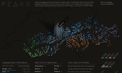
Peaks is a visualization of Swiss mountain peaks by Raphael Schaad, a designer at the MIT Media Lab.
https://raphaelschaad.github.io/peaks/
He uses four colors to distinguish the language (there are four official languages in Switzerland) of each name. In addition to color (hue) he also uses lightness (value) to represent height. The highest peaks are almost white making the language more difficult to determine. As you hover over a peak, you get the name and height of each one.
There is an About this Visualization link you can click to get some insight into Raphael's design process. Here is a quote about the stories he looks to tell.
The first narrative explores the impact language has on naming (e.g. Romansh’ names have much wider reach than the region this language is spoken in), the second story shows common names (similar to almost every U.S. state having a Springfield), and the third one highlights three colors as common origins for names. Each of these narratives is also interactive and tied to the central map.
 I like way he presents the legends,
and the supplemental language details.


Tuesday, October 11, 2016

Favorite Maps-Part 2

Erwin Raisz - Landforms of the United States, 1957
http://www.davidrumsey.com/luna/servlet/detail/RUMSEY~8~1~231095~5508485
Raisz was a Hungarian civil engineer. When he came to the United States he began working for the Ohman Map Company in New York City where he also taught one of the nation's first cartography classes at Columbia University. Eventually he ended up at Harvard University where he also curated their excellent map collection. His artistic talent, memory, eye for detail and scientific knowledge combined to make a remarkably detailed and beautiful map.
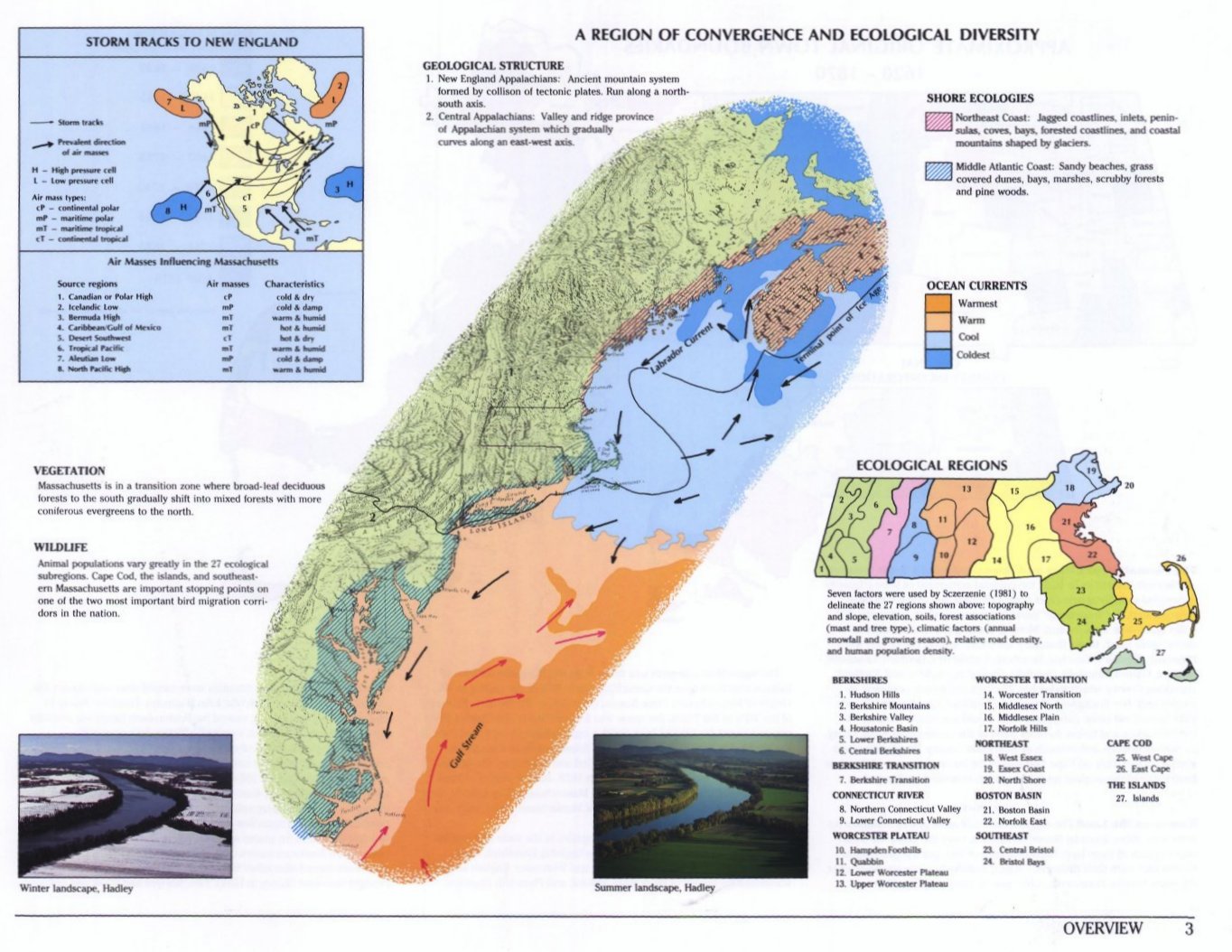
I first encountered this map in 1991 when working on the Historical Atlas of Massachusetts. We used the map as a backdrop for the a graphic showing the geology and ecology of the northeastern United States.
http://www.geo.umass.edu/faculty/wilkie/Wilkie/hist_mass_p3.jpg
 I've been fascinated with this map ever since. Here are some nice details.
He uses some gorgeous hand lettering-especially for the water features. Note the ancient glacial lake shoreline at the western edge of this section. I'm also intrigued by his space saving labeling of smaller cities ("S" for Sandusky, "Y" for Youngstown, etc.) This is one example of the kind of unconventional techniques that make me uncomfortable, but in a good (teaching moment) kind of way.
Another unconventional technique - where the landforms were either less well explored or not available, he created a mostly empty space with the text "Laurentian upland of low hills and many lakes." I find it curious that Mexico is mostly empty, except a small area along the California and Arizona boundaries, while Canada is mostly filled in.
The legend showing multiple features in one box - another unconventional but very successful approach.

 Dramatic landscapes look great...
...but even in mostly flat areas, such as this part of Kansas, he still managed to keep the features interesting.
You can browse this map from the David Rumsey Map Collection.

Raisz created similar maps for regions around the world.
A list of his and purchase prices can be found at the Raisz Landform Maps web page.

Tuesday, June 17, 2014

Training through Nevada!

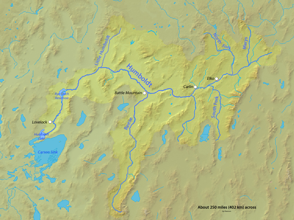
I have made it to Nevada! We are traveling along the Humboldt River which drains most of northern Nevada, but does not ever reach the ocean. The river drains into the Humboldt Sink, a dry lakebed. It forms a natural transportation corridor across the state and Amtrak's California Zephyr uses this valley to get across the state


Pass the salt!


Wednesday, June 11, 2014

Continental Divide Interrupted

In the Teton Wilderness of northwestern Wyoming the Two Ocean Pass creates a small hole in the Continental Divide. North Two Ocean Creek flows across a ridge and then splits into two distributaries, Atlantic Creek and Pacific Creek. Atlantic Creek flows into the Yellowstone River, then to the Missouri and Mississippi Rivers, Gulf of Mexico and Atlantic Ocean. Pacific Creek goes to the Pacific Ocean via the Snake and Columbia Rivers.
This joining of waters allows fish such as the cutthroat trout to migrate across the divide, from the Snake River to Yellowstone Lake (source National Park Service.)

There are several other gaps in the Continental Divide as shown on this map. 

The areas with double red lines are endorheic basins. They do not drain externally-water flows into swamps, the ground, or it evaporates. The Great Basin (in brown above) is a large example of this. I plan to travel through there next week and may have more details about that region.

There are a couple of other places where waters cross the Continental Divide in North America. These include Divide Creek near Kicking Horse Pass in the Canadian Rockies and Isa Lake in Yellowstone National Park. Isa Lake (autocorrects to "is a lake") has streams that flow westwards to the Atlantic and eastwards to the Pacific which is totally backwards!

Thursday, July 25, 2013

Where Does That River Go?

If you're like me you look at a stream and wonder where it comes from or where it goes. The National Atlas has a new tool called Streamer. Click on a stream and you can trace it up or downstream. Here is the path of Butternut Creek in Charlotte, Michigan to Lake Michigan.
Tracing upstream is much more complicated. You get all the possible tributaries above you. Here's a trace of the Tennessee River near its mouth in Kentucky.
Unlike Streamer, rivers do not care about national boundaries. If you trace the Pend Oreille River downstream from Idaho, you get stuck at the Canadian border in Washington. The river itself only makes a short trip into Canada where it empties into the Columbia and heads right back into Washington but this is not shown in Streamer.
I like a good long windy path like the one made by Cassadaga Creek south of Buffalo. It starts just a few miles from Lake Erie but goes the other way instead.
Or Wyoming's Wind River.
Pick your favorite river (if you have one) and give it a try.

Wednesday, February 9, 2011

Map of the Week-River Systems

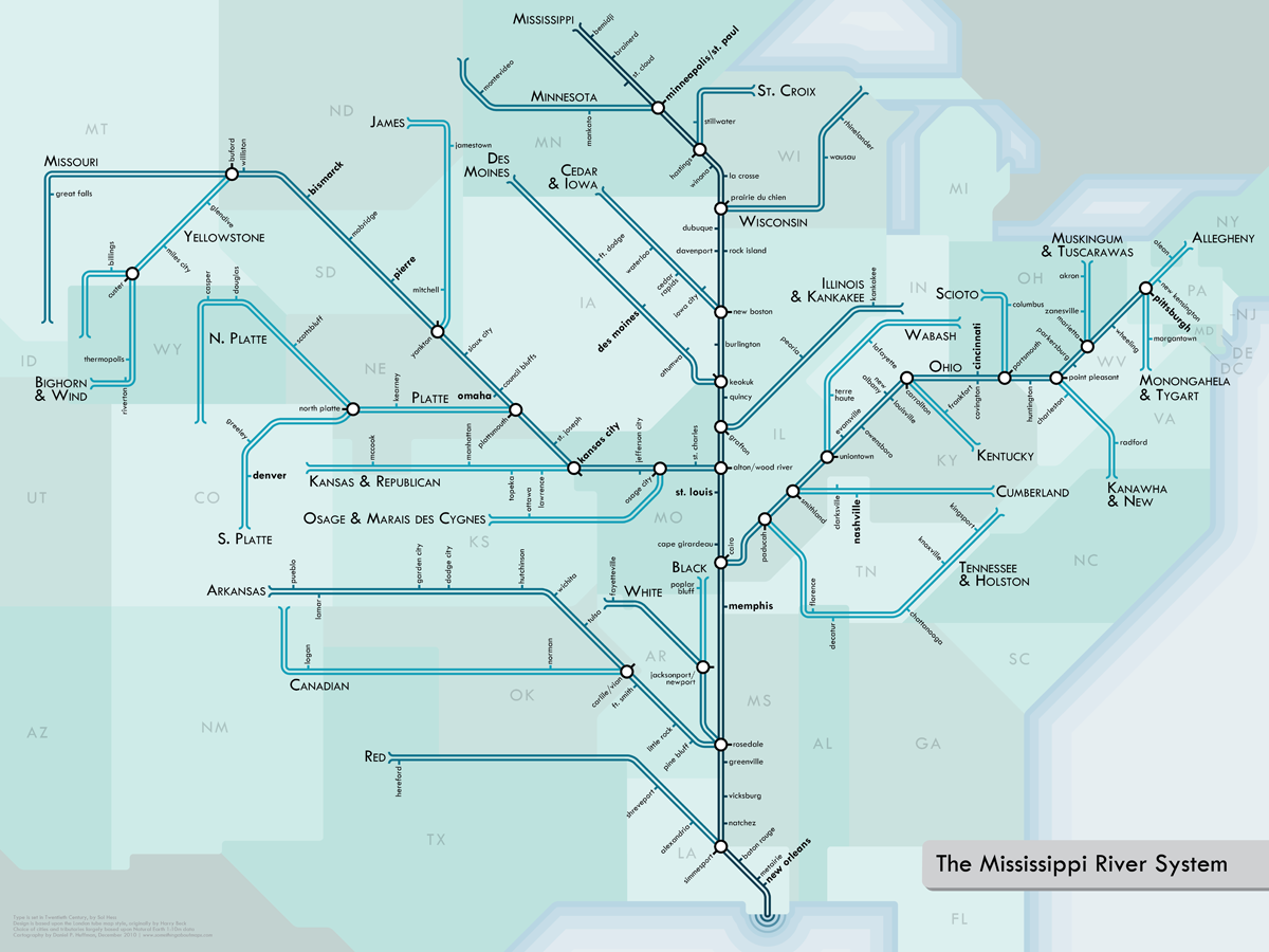
Last year, I featured a map from London's Waterways, using a Harry Beck London Underground inspired schematic.  Cartographer Daniel Huffman has created a beautiful series of schematics for various river systems here in the USA. Below is the Mississippi River System.


Details about the creation process can be found on his blog. Prints can be purchased here. Here are some nice detailed views from the series.

The Mississippi/Ohio jumble:

Boston Metro (from the "Southwest New England" map):
 
Michigan:

The Mighty Columbia:

Thanks to Cartogrammar for the heads up.