Showing posts with label rome. Show all posts

Wednesday, January 31, 2018

Map Acquisition Syndrome

Map Acquisition Syndrome - is there a cure? I have been given so many maps by people clearing out their apartments that it has overwhelmed my filing system. Many have been sitting in shopping bags for a year now while I figure out what to do with them. Here are some paper maps people have foisted on me knowing I can't say no. This is therapy-before I file them away I need to show off my bounty.

Insight FlexiMap of Budapest - so shiny it's hard to get a good picture.
For contrast here's the Budapest tourist agency map  
Details from the shiny flip side of the Insight map - the road to Lake Balaton and the Metro
 
Rand McNally map of Italy-an undated map from a Fodor's travel guide. The credits mention a Stuttgart office that no longer seems to exist. 
Here is a newer Fodor's map of Naples. This one produced by the British map company Lovell Johns.
Old Quebec - a nice pictorial map  
"Marco Polo" map of Russia. These maps come with stickers so you can mark places of personal interest. 
Same company-Thailand, Vietnam, Laos and Cambodia. Note the delicate task of naming Saigon. 
Official City of Rome tourist map with pictorial details.
Monte Carlo tourist agency map
Bilbao Turismo
Bilbao Transportes 
AAA map of Tucson
Sorry for the poor quality of some of these pictures. I don't have a professional map photography setup. There are many more - stay tuned for another installment.

Wednesday, September 7, 2016

The Seven Hills of Everywhere

Rome was built on seven hills. Here they are (the ones inside the city walls):
http://octavianchronicles.com/wp-content/uploads/2014/11/RomeColor730rev7.jpg

Many other cities decided that they wanted a piece of Rome's glory and created their own seven hills legends. Here is Wikipedia's extensive list of cities claiming to have seven hills. Of course the nature of hills make it easy to cherry pick various topographical features to come up with seven hills, and also to dispute those claims. Cincinnati seems like a good example of a city that's trying too hard to arrive at exactly seven hills.
http://www.diggingcincinnati.com/2014/03/cincinnati-city-of-seven-hills.html
Also cities tend to expand to include more hills and many of the original ones have been leveled. Here is a collection of various seven hills maps for your reading pleasure.

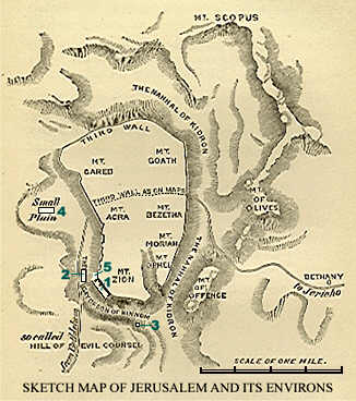
Jerusalem - they had seven hills long before Rome. Here is a sketch showing seven hills within the old (third) city wall 
http://www.centuryone.com/images/exploredjerusalem.jpg


One of the first cities to jump on the seven hills bandwagon was Constantinople (Istanbul) - here is a map from the Hebrew wikipedia. The hills are numbered but not named.
https://commons.wikimedia.org/wiki/File:Seven_hills_of_IST.png

Rome, Georgia - if you're going to name your city Rome, it might as well have seven hills.
https://en.wikipedia.org/wiki/Rome,_Georgia#/media/File:Rome_Georgia%27s_7_Hills_and_3_Rivers.png


Richmond, Virginia took the extra step of listing their seven hills in a 1937 ordinance. The goofy colored triangles represent "official" hills. Several other gray triangles shown are "unofficial" hills. The far west hill is called "Oregon" because that's how far west it seemed to the rest of the city at the time. The complete list is here. You can explore them interactively here.
http://www.rvabusiness.com/2012/06/28/the-seven-hills-of-richmond/


St. Paul, Minnesota - they can only agree on five of them, and some of them are really just bluffs rising up from the river. A full accounting of them can be found here.
https://www.minnpost.com/stroll/2015/07/st-pauls-7-hills-there-seems-be-agreement-5-them

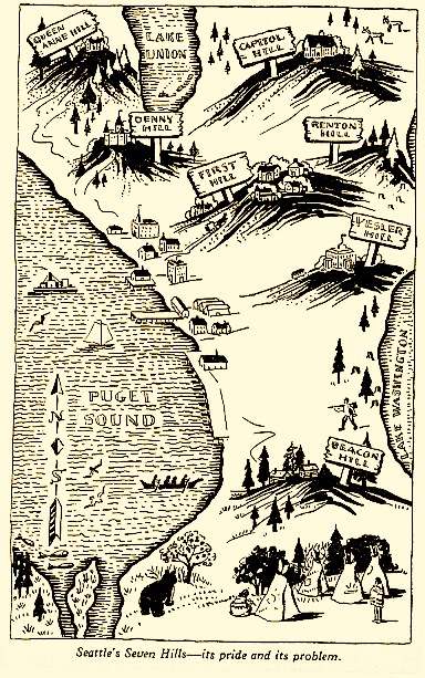
Here is a nice map and description of Seattle's seven hills...
http://geologywriter.com/blog/seven-hills-of-seattle/
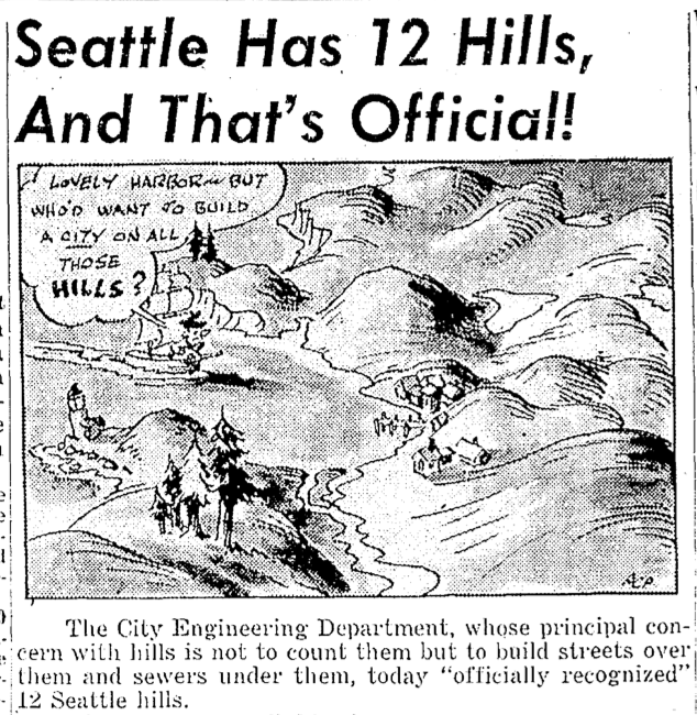
... except maybe there are really twelve?
http://geologywriter.com/wp-content/uploads/2014/10/Screen-shot-2014-10-20-at-6.01.07-PM.png

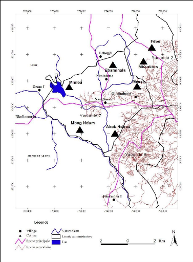
In Africa, Yaoundé, the capital of Cameroon is known as La Ville aux Sept Collines (city of seven hills)  - all of them are on the west side of the city.
http://www.memoireonline.com/01/13/6854/Anthropisation-et-risques-environnementaux-sur-les-collines-de-Yaounde16.png

Thiruvananthapuram-capital of Kerala Province India
Maybe not. The Hindu (souurce for this graphic) says "if we start counting the hills in the city, it becomes confusing. Hills there are, but to decide on the seven that the city rests on, is near impossible. The really high hills are outside the city."

Near me Somerville, Massachusetts claims seven hills and has a park devoted to them with cute towers marked for each hill.
https://summerinsomerville.wordpress.com/tag/seven-hills/
I was unable to find a good map of the seven hills so I made my own hand drawn one. Enjoy!

Tuesday, December 31, 2013

I Saw a Peutinger Map Replica at ISAW

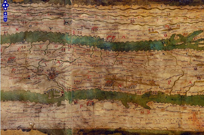
This weekend I was in New York City and had a chance to wander over to the Institute for the Study of the Ancient World (ISAW) to see their exhibit, Measuring and Mapping Space: Geographic Knowledge in Greco-Roman Antiquity.  The exhibit features a 1:1 scale digital replica of the Peutinger Map, the only known surviving world map from the Roman Empire. This is a medieval era copy of a map from Roman times housed at the Austrian National Library in Vienna. The map is over 22 feet long and only about 13 inches wide. The digital replica takes up one wall of the gallery. Here are some photos from my phone. 
The map is centered on Rome. Above are the roads radiating out of Rome, including the Appian Way. It is meant to show a schematic road network and the extent of the empire's control from the British Isles to India and Sri Lanka. The geography is highly distorted to fit the dimensions with the areas closer to Rome much larger and more accurate. Expanses of open water are reduced to narrow channels. Small cities are represented by twin towers while larger ones show temples and other complexes. The largest cities, Rome Constantinople and Antioch are shown with more elaborate symbols. Below is a section in Mesopotamia.
You can see these areas much more clearly on the ISAW map viewer. This allows you to pan and zoom around the entire map, except for the far western edge - missing from the original map. You can also add lines and text digitized from the original for clarity.
http://peutinger.atlantides.org/map-a/
Wikipedia also has a cleaned up high resolution image of the map. The missing western areas were reconstructed by Konrad Miller in 1887-88 and show up with a white background. The original parts of the map are shaded in yellow. The preview image below gives you an idea of the map's crazy dimensions.
http://en.wikipedia.org/wiki/File:TabulaPeutingeriana.jpg

The exhibit at ISAW only goes until January 5th, but hopefully the online resources will remain available.