Showing posts with label architecture. Show all posts

Wednesday, September 14, 2022

King Charles III-Urban Planner

Britain's new King has a strong interest in urban planning. In fact he helped design a "new urbanist" town, Poundbury, just outside of Dorchester in Dorset. Here is a photo, via Flickr, of an in situ map of the town as it was in 2008. Click for better readability.

from Flickr user Anne

The town's traditional architecture gives it an (artificial) old-time feel while embracing principles of sustainability such as use of local materials, renewable energy sources like biomethane, and energy efficient designs.

Image via Duchy of Cornwall

A 2016 article in the Guardian begins with this quote: "Poundbury, the Prince of Wales’s traditionalist village in Dorset, has long been mocked as a feudal Disneyland. But a growing and diverse community suggests it’s getting a lot of things right."


This image from planner Léon Krier shows how much of the plan had been completed (in black) as of 2013.

via Architect Magazine

Here is a somewhat dulled image of the master plan showing land uses.

via DorsetRoads

The streets are designed to slow traffic and the walkability index is high according to Space Syntax,

however "the progressive attitude to cars hasn’t curbed habits: a survey conducted at the end of the first phase showed that car use was higher in Poundbury than in the surrounding rural district of West Dorset. The free-for-all parking policy, meanwhile, has turned many of the streets and squares into a car park for Dorchester shoppers." - Guardian, 2016

The town is scheduled to be completed in 2025 and a look at Google Maps suggests it is getting close.


Wednesday, December 2, 2020

Albert Kahn Architecture Map

Detroit's legendary industrial architect Albert Kahn left an impressive imprint locally and throughout the country. His firm has a nice interactive map of his legacy projects.

The map features residences, offices and walking tours.

Click on a project for pictures and details.


Zoom far in for some nice 3D details,


and zoom far out to see the nationwide scope of his work.

-via DETROITography


Wednesday, December 11, 2019

Jerusalem Over and Under

This month's National Geographic has a remarkable map showing Jerusalem's buildings and sites throughout its many eras of settlement. The fold out map is best seen on paper in the magazine but here is an image of it from Twitter,


and a still frame from the animation above.

The tweet above begins an interesting thread of tweets detailing some of the challenges in creating these graphics. Here is another tweet from that thread showing some of the 3D buildings

One minor issue I have is the size comparison below. While most of us on the east coast of the United States understand this, I'm not sure how meaningful this is to people in other areas of the world.
For bonus content their web page lets you scroll through historical eras to see models of various buildings.
https://www.nationalgeographic.com/history/2019/11/see-centuries-of-architecture-in-jerusalem-feature/


Wednesday, August 9, 2017

The Guardian Building Mural

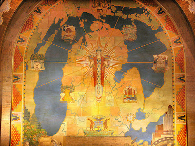
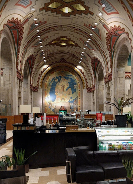
Next time I visit Detroit the Guardian Building, an art deco "cathedral of finance" will be on my must see list. Not because it is a "timeless depiction of creativity and accomplishment" but because of the Michigan map mural. Just look at how it's situated! It's like the Cathedral of the Holy Map!
https://www.flickr.com/photos/amberwillits/26418884725/
The map on its own does not show much - mainly colored counties and water bodies along with various figures and coats of arms. If you're a Michigan purist you will note that most of the Upper Peninsula is missing. Its more about how the map is displayed.
https://www.flickr.com/photos/zxgirl/6464055379/
Here I have zoomed in a bit for better detail
https://www.flickr.com/photos/zxgirl/6464055379/
The above pictures are from this page on flickriver but you can also go inside the lobby on Google StreetView.
https://www.google.com/maps/@42.32956,-83.045978,3a,75y,156.89h,90.99t/data=!3m8!1e1!3m6!1sAF1QipNBHFcqNNfQPgDpGmxahv14IvZqy6GAIAScFYET!2e10!3e11!6shttps:%2F%2Flh5.googleusercontent.com%2Fp%2FAF1QipNBHFcqNNfQPgDpGmxahv14IvZqy6GAIAScFYET%3Dw203-h100-k-no-pi-0-ya223.32114-ro0-fo100!7i7168!8i3584
You can also see some great art deco details from the links above including a Tiffany glass clock, a stained glass Native American mosaic, light fixtures and even details around the elevator doors.

Wednesday, May 18, 2016

Spaces We Love

The American Institute of Architects 2016 Conference opens this week in Philadelphia. The local chapter has put together Spaces We Love - a series of videos in which 11 residents were asked to describe their favorite spaces in the city. This seems like a project in need of a map so I decided to take it on as a learning experience for the CartodB platform. You can interact with it (click the black AIA logos for info and videos) below or see it in full screen here.

Wednesday, December 2, 2015

Chicago Transit, Frank Lloyd Wright Style

Last week's post featured some maps from Max Roberts. Another recent project is this map of the Chicago "El" in the style of Frank Lloyd Wright.
http://tubemapcentral.com/pod/chicago_flw.jpg
The map captures Wright's Arts and Crafts style aesthetic with the use of clean lines and fonts. I do find the font a bit difficult to read, however.
The map's outline and stop symbols were inspired by Wright's stained glass work, as seen clearly on the loop inset.

https://en.wikipedia.org/wiki/Frank_Lloyd_Wright#/media/File:RobieHouseWindows_ChicagoIL.jpg


One final nice detail is the diagrams of each line along the sidebar.
This map, the ones highlighted last week, and lots of other cool designs can be purchased at Roberts' Tube Map Central Site.