When I see a river, I often think about where it comes from and where it goes. I started a mapping project showing this for the Northeastern United States. For the level of detail needed it was necessary to choose a manageable area so I chose where I've lived almost all of my life. Here is the view at full zoom.
This project was done using
Felt, a nice package for collaboration or in this case merely making an interactive map. There is some subjectivity here; what are the most important rivers and where are the headwaters. The second one can be problematic because most rivers have many branches. This is especially true of the Susquehanna, with its north, south and west branches. On this map as you zoom in, the detail increases and the locations shift to indicate the many possible headwater locations.
For example, the Susquehanna River (North Branch) is considered to start at the outlet of Otsego Lake in Cooperstown, New York. However, there are numerous creeks that flow into that Lake from all directions. In this case I chose to show the two northernmost creeks.
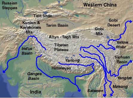
This fall I drove through northeastern Pennsylvania and was hoping to see the point where the headwaters of the Genesee and Allegheny Rivers (flowing in opposite directions) come within a few hundreds of feet of each other near Gold, PA. Maybe it's not as impressive as the areas of the Himalayas where several of the world's most major rivers flow in parallel valleys,
but it's much more accessible to me. Unfortunately a construction detour and a wrong turn sent me in a different direction.
I made another version that shows the river mouths in red. Again, this can be subjective, especially in the case of the Allegheny which really flows all the way to the Mississippi (or the Gulf of Mexico depending on the definition of mouth).
Explore the map
here.