Showing posts with label nebraska. Show all posts

Wednesday, August 2, 2017

Where to See the Best Eclipse Maps

It's not about where to go to see the upcoming eclipse (August 21st, 2017) -it's where do you see the best maps that interests me. The Great American Eclipse site is a good starting point. They feature very detailed maps showing how much time the total eclipse will last.
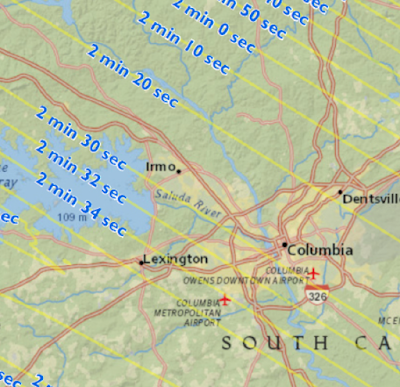
https://static1.squarespace.com/static/53c358b6e4b01b8adb4d5870/53eee705e4b0b80451132d74/53eee74be4b0880c7d4f6c09/1408166076430/SouthCarolina_Central.jpg?format=1500w
Above is the area around Columbia, South Carolina where some friends of mine (and possibly me but that is unlikely at this point) are gathering. I'm not sure why they want to drive 30 miles to get an additional 10 seconds of eclipse time but maybe it's better watching it over Lake Murray. Hopefully they get a sunny day-chances are much better of that in Nebraska or Wyoming.

This site features maps of the nation, for each state, drive time maps, videos of the path, lots of highly detailed maps like above and statistics. You can also buy "Occupy Totality" T-shirts. I like their logo too.
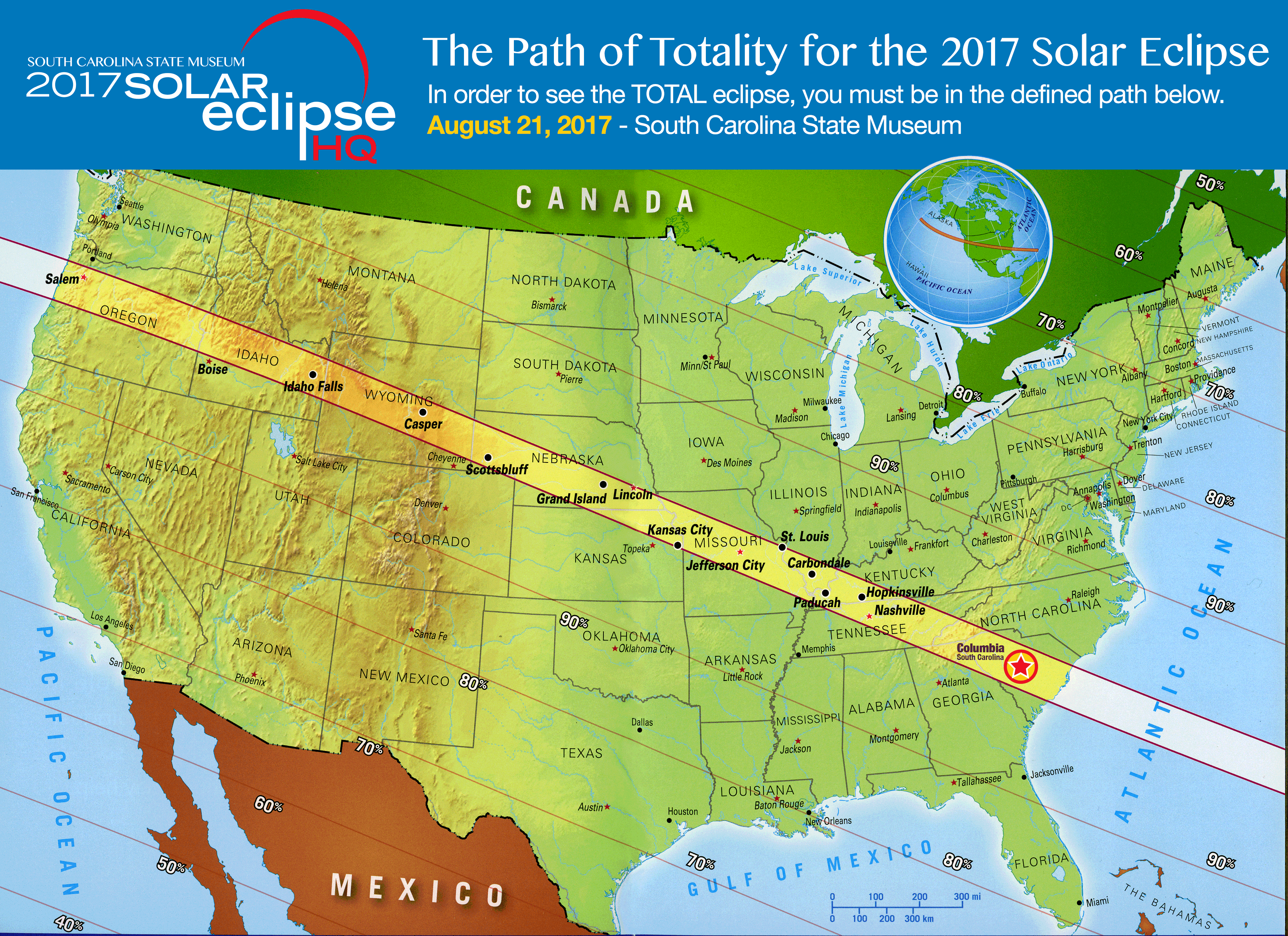
Here is a simple nationwide map from the South Carolina State Museum via the Columbia Total Eclipse Weekend site.
http://totaleclipsecolumbiasc.com/wp-content/uploads/2017/04/solar-eclipse-map-2017.jpg.png
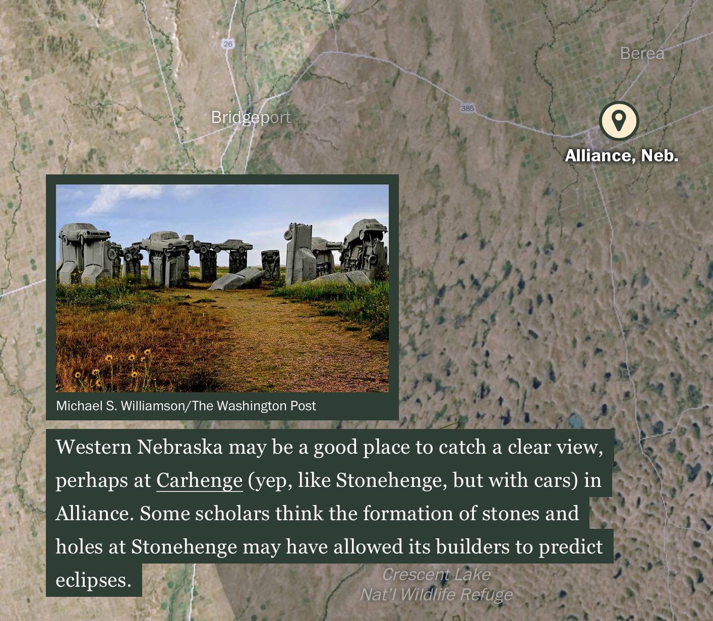
The Washington Post has a great page where you can scroll down and follow the eclipse's path. Here are two screen shots of Oregon.
 Also Carhenge, because Carhenge is awesome.
Teams of students under the Eclipse Ballooning Project will be sending up high altitude balloons with cameras across the country to live stream the event. You will be able to watch here.
Rexburg online (Idaho) has a nice simple state map.

You can see where future eclipses will be from Scientific American. Their interactive graphic works nicely for small countries...
...but gets unwieldy for larger ones.
There are probably many other good graphics. You can look up at the sky or look online for more maps. If you are in the USA and you miss this one, there will be another one in seven years. Click the picture for more details.
https://www.greatamericaneclipse.com/april-8-2024/


Wednesday, January 14, 2015

Big Ten Games of Thrones Map

Like many Americans, I spent way too much time Monday night watching the NCAA Championship football game. While not paying total attention, this commercial for the Big Ten Conference really jumped out at me. The commercial is called "Maps" and is based on the Game of Thrones intro (with the same music.)
It constructs a flyover of the US, starting at the Rose Bowl. As you pass by iconic buildings, stadiums and landmarks pop up from the landscape. Here is a tour using screen grabs from YouTube.

From the west coast you fly across the mountains to Nebraska, the current westernmost outpost of the conference.

Next comes Iowa, then Minnesota, then Wisconsin.
One of the most dramatic moments is watching the Chicago skyline pop up in front of the Northwestern logo. Note the theater references for Northwestern and Iowa. The mist coming off the Ohio River adds to the medieval theme.
The Michigan-Ohio State rivalry is about as big as it gets.
From there, it makes the jump to the east coast to cover the conference's recent acquisitions. Here are Penn State and Maryland with east coast icons such as the Capitol building, Washington Monument, LOVE statue and the Liberty Bell.
The flyover heads over the Atlantic and turns back to the west to include Rutgers the "birthplace of college football" (according to the ad) along with the NYC skyline and the ferris wheel at Seaside Heights, New Jersey. I like the reflections off the water.  
The full video is at the top - enjoy!

Tuesday, November 25, 2014

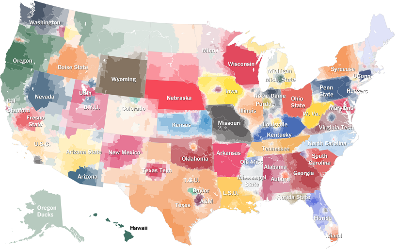
College Football Fan Map

The New York Times Upshot recently added College Football to its collection of fan maps.
http://www.nytimes.com/interactive/2014/10/03/upshot/ncaa-football-fan-map.html?action=click&contentCollection=The%20Upshot&module=RelatedCoverage&region=Marginalia&pgtype=article&abt=0002&abg=1&_r=0
I like how faithful the boundaries are to the state borders. Even in Kansas where they have a reciprocal arrangement with Missouri for in state tuition and plenty of students from Missouri, the boundary is pretty precise.

Using the university colors is a nice touch but it also has the effect of overemphasizing the red schools. What really jumps out here is Nebraska, Wisconsin and Ohio State, whereas Oregon's impressive reach into California, Montana and Alaska fades info the background. The other problem with the college colors is when you have similar adjacent colors. It's especially hard to distinguish Alabama and Georgia here. South Carolina and Auburn are also in the same color family.

I also like the small pockets of fandom for the lesser state schools such as Michigan State, Kansas State, Iowa State and that little university in Virginia whose relative lack of football success has made Virginia Tech the overwhelming choice of most of that state.   

The Upshot did a related map showing where college football is the most popular.
http://www.nytimes.com/2014/11/08/upshot/the-places-in-america-where-college-football-means-the-most.html

While I'm not convinced that the Facebook "like" is the most reliable measure of our culture, it does make for an easy data set and results in a clear pattern. If this map was done in a grey scale, reversed out and overlaid on top of the first map, you'd get a picture of not only who people like but how strongly. I'd do it if I had time but work beckons.


Wednesday, January 30, 2013

The Newberry Library Part 2

This post is a continuation from last week detailing my recent visit to Chicago's Newberry Library. In the map room was a book of maps of the Oregon Trail. Having gone to graduate school in Lawrence, Kansas near the beginning of the trail, it caught my attention.

The full title is "Topographical Map of the Road From Missouri to Oregon Commencing at the Mouth of the Kansas in the Missouri River and Ending at the at the Mouth of the Wallah Wallah in the Columbia." Produced in 1846 (when the Oregon Treaty settled a boundary dispute with the U.K.) by order of the U.S. Senate, this map is from the field notes and journal of Captain John C. Fremont, and sketches and notes from his assistant Charles Preuss. There are seven sections, above is the first, easternmost section.

I like that Westport, now the place to go in Kansas City to see bands and watch drunk 20 year olds get into fights, was its own little village. Actually, it was probably a much rougher and rowdier place back then. This detailed view came from the David Rumsey Map Collection where you can see the full maps with much better clarity.

The sections feature charts of meteorological observations for sunrise, noon and sunset for each day of Fremont's expedition.These include the temperature, altitude, wind direction and brief weather descriptions such as "perfectly clear" or "occasional thunder and light."

The locations of the expedition for each day are shown on the map, along with "cyphers" listing the distance from Westport. Each section has notes in the corner that provide some good atmosphere and local color. These are from section 1:
This section abounds with grass, water and fuel so that emigrants may encamp almost anywhere.
Elk and deer, the only game, are very scarce.
Selected notes from the other sections provide lessons in geography and attitudes towards non-whites.
Game - Antelope and Buffalo, the latter in innumerable bands.

Timber is extremely scarce, except on the islands*. Some driftwood and buffalo excrement makes the fuel as that of the camels does in the deserts of Arabia.

Good guard ought to be kept. Pawnees, if they do not kill, will at least take what they can from the travellers [sic] by force if they are strong enough, and by stealth if too weak to act openly.

With this section** the prairie ends, and the barren sage (artemisia) country begins.

East and West of this section [section 3] more or less buffalo and antelopes, but 50 miles from Fort Laramie each way no game is to be found. Grass - is scanty and only occures [sic] on the banks of the rivers and creeks.

At Sweetwater River*** buffalo appear for the last time and emigrants should provide themselves with well dryed meat.

West of the Green River the traveller [sic] is considered out of danger, as the Snake Indians are considered friends of the whites. Property however should be guarded.

This is the most trying section**** for the traveller on the whole route. Water, though good and plenty is difficult to reach, as the river is hemmed in by high and vertical rocks and many of the by-streams are without water in the dry season. Grass is only to be found at the marked camping places and barely sufficient to keep strong animals from starvation. Game there is none. The road is very rough by volcanic rocks detrimental to wagons and carts. In sage bushes consists the only Fuel. Lucky that by all these hardships the traveller is not harassed by the Indians, who are peacable [sic] and harmless.
Of course, these notes also provided highly valuable information for emigrants heading west.
 
*     the islands of the Platte River
**   section 2 covering the area between 98 and 102 degrees west longitude along the Platte River. 
***  near the continental divide
**** section 6-along the Snake River between Fort Hall (north of Pocatello)  and Fort Boise in Idaho.


Wednesday, December 12, 2012

12/12/12

Happy 12/12/12!


 Here are some maps and boring facts about highways designated as Route 12 - mostly from Wikipedia.

US Interstate 12 is one of the shortest major (one or two digit) interstates in the country running 85 miles along the north shore of Lake Pontchartrain all in Louisiana. It is a shortcut that takes you from Interstate 10 back to Interstate 10 avoiding New Orleans. The road is also officially called the Republic of West Florida Parkway, in honor of that short lived republic created from an 1810 rebellion against Spanish rule.


By contrast US Route 12 is an almost cross country route running from Detroit to Aberdeen, Washington, almost 2,500 miles. The photo on the lower left was taken near the intersection of Michigan Avenue and Cass, where Route 12 officially begins. This photo came from the US Ends, a web site for people like me who are obsessed with where roads begin and end. On the left is a map of the Grays Harbor area at the western end of Route 12.


South Korea's Expressway Number 12 is also called the 88 Olympic Expressway. It runs across the southern part of the country.


There's many other highway 12's listed on Wikipedia's List of highways numbered 12 inlcuding the following three non-US routes chosen because I like their route shields.


Finally realizing that I forgot the awesome Kansas sunflower route shields (despite K-12 being retired,) here is another set of US state route shields. Once again, Happy 12/12/12!