Showing posts with label finland. Show all posts

Monday, November 20, 2017

Baltic Sea Traffic

This is gorgeous and mesmerizing. That is all. Have a good day.

Wednesday, March 2, 2016

The Flavors of Finland

Sautéed Reindeer , Crucified Whitebait, Lingonberries - also Tarbread (a secret recipe) Explore the flavors of Finland with this interactive map from Expedia Finland.

Click the food picture to get a recipe-except for Tarbread ('cause it's a secret). The Lapskoussi recipe calls for "chopped swede" - hope that's not what it sounds like!

Thursday, December 31, 2015

A Few Nice Maps from 2015

There are lots of best maps of the year posts on other sites. You could spend hours looking at the Maps Mania 100 Best Maps of the Year - not a bad way to spend your time if you have it. I also highly recommend Cartonerd's favorite maps list. I am not nearly that ambitious, nor can I pretend to have seen every good map that has been made in the past year. Instead, I will show three maps that I never got a chance to post during the year. I really like these, but will make no claims about their "best"-ness.

The Magnificent Bears of Finland - Annukkah Makijarvi*
http://grrr.fi/annukka-makijarvi/bears-of-finland-map/
This is a deceptively simple looking density map showing the population of bears by area.** If you look closely though the areas are made of of bears. A great synthesis of art and cartography.
* I think this map may be a couple of years old by now but it made the rounds on the map sites this year. 
** Not completely sure what the areal unit used here, a sort of bear grid perhaps.

Longyearbyen and Environs - Norwegian Polar Institute.
http://www.npolar.no/en/services/maps/printed/3d-longyearbyen.html
This map shows an area of Svalbard, an Arctic island off Norway. It is another artistically beautiful map. The International Cartographic Association's Map of the Month for November, 2015. Here are two zoomed in details.

Sculpteo's 3-D Printed Maps

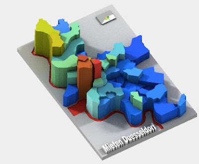
These "datasculptures" can be rotated in three dimensions, even in their preview views. They include several demographic maps, mostly from Germany. This example shows rents in Dusseldorf.
http://www.sculpteo.com/en/print/rent-level-duesseldorf-2012/Af3eGfhE?basket=1&noclickredirect=1&uuid=UZr77M6goy9bhc2drEzSRh

Looking forward to another year of mappy goodness!


Wednesday, June 3, 2015

Beeswax Maps

Ren Ri is a Chinese artist and beekeeper. He uses beeswax as an artistic medium, creating sculptures and maps.
Above is "Indo-Malay Islands" from his "Geometric Series." Maps and other artworks were recently displayed in the PearlLam Galleries in Hong Kong. These images were taken from the exhibit's catalogue.
 "Korean Peninsula"

 "Mongolia"
 "Argentina" and "Scandinavian Peninsula"

"South Pole"
 "World"


Thursday, January 10, 2008

Map of the Week 107-Mexico City 1550

The Map of Mexico 1550 Project was designed by Lily Diaz, a professor at Media Lab Helsinki. The map is reputed to have been authored by Alonso de Santa Cruz, royal cosmographer to emperor Charles V of Spain. It resides at the Uppsala University Library in Sweden. She took a series of overlapping, stereo images of the map and pieced them together as one digital image. Then a series of historical points of interest were laid on top with descriptions, photos and web links. As you zoom in on regions of the map these squares will get larger and pop up information as you hover over them. The author's description of the map is below:

"Painted on two sheets of parchment joined together at the center, the map shows the city surrounded by water and with canals between its buildings. The clearly drawn roads over the mountains to other parts of the country permit us to retrace the routes taken by the Spanish conquerors. The map also provides abundant information about the ethnography and the flora and fauna of the region during the early colonial days"