Showing posts with label netherlands. Show all posts

Wednesday, August 7, 2024

Summer Light Reading 2024

Here is another installment of what is becoming an annual summer tradition. Just like the light beach reading, here is some light map reading. Not much to comment about, just some maps and related items I like.

First of all since the Olympics are in Paris, a nice papercut map you can enjoy, or buy here.

A very colorful map from Wikimedia Commons showing the different sections of the Rhine River. As one reader pointed out it looks like a water quality map and probably is as river quality tends to get worse as more cities and farms downstream dump pollution into them.

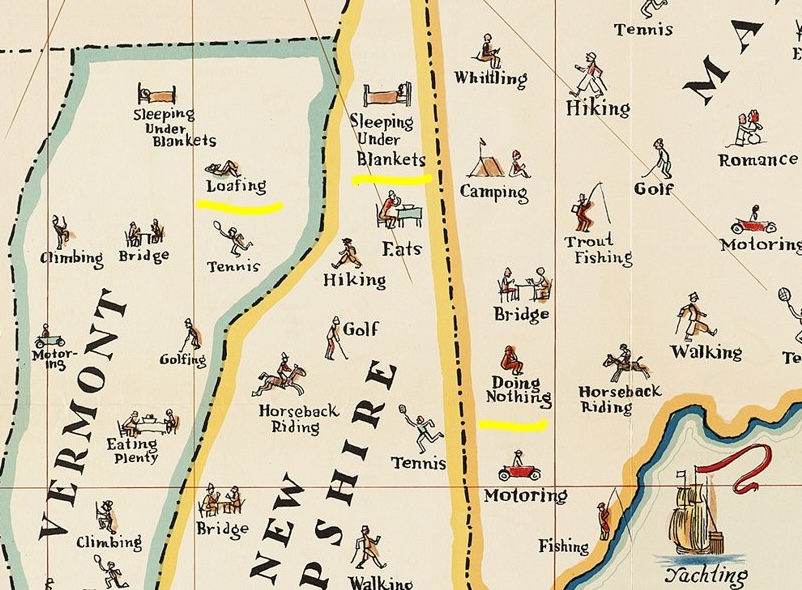
A map of things to do in New England. I copied a portion and highlighted some of my favorites such as "loafing", "sleeping under blankets" and "doing nothing".

Transit map of Kaohsiung on Taiwan. There are some great station names like Dream Mall, World Games and Oil Refinery Elementary School.

A screen shot from Yahoo Japan that I like for no specific reason.

Finally, Tsunami Generating Earthquakes. I think this originally came from some social media site that was once known as Twitter. Maybe from the U.S. Geological Survey.

OK, back to your beach read.

Wednesday, June 15, 2022

Global Inflation

Inflation is causing economic stress here in the United States. It is often covered in the news as a failure of the US economy, but as this map shows, inflation is a global phenomenon and the United States is in one of the lower categories.

The map, via statista show projections from April, 2022. The countries with higher rates tend to be "developing nations" that are experiencing inflation as a consequence of economic growth. The highest rates are found in countries that are experiencing conflict such as Venezuela (500%*-ouch!) and Sudan. The accompanying article on statista, explains the inflation situation in much greater detail. 

Another map from statista, that is on Forbes, shows global gas prices.

The United States is in the middle category here but still gas is much cheaper here than in Canada, Europe, South and Eastern Asia and Australia. While this map is also a few months old, the current info from Global Petrol Prices still has the US in the same approximate position.

While looking for more information on statista, I found this interesting map showing ships are currently jammed up trying to get to the ports of Rotterdam and Antwerp. Delays in container shipping are one of the major stressors contributing to inflation.

* In looking at inflation trends I've seen other numbers for Venezuela that are around 250%. I imagine it's not easy getting accurate numbers given the political turmoil in that country.

Wednesday, April 10, 2019

La Jolla Map Museum - Maps of Historical Interest

Last month I visited the Map & Atlas Museum of La Jolla. They have an impressively large collection of original maps and many of them are of significant historical importance.

For example, here is one of the earliest recorded maps - baked onto a clay tablet.
Photo taken at the Map & Atlas Museum of La Jolla
It shows a parcel of land with ownership and dimensions in cuneiform. On the back are field measurements. This could be a legal document or may have been used as a teaching tool for surveying.

Here is a world map by Antonio Floriano (ca. 1555) using polar projections from the north and south poles. I took most of the following pictures on a phone so try to ignore the glare and reflections. Where possible I will provide links to better images online.

Photos taken at the Map & Atlas Museum of La Jolla

Each hemisphere is divided into 36 globe gores and therefore it was likely to have been designed for making globes. A better image can be found at The Vintage Map Shop. Here is some detail from the eastern Mediterranean.

A very different world map from a similar era (1581) is Heinrich Bünting's World Map.
Photo taken at the Map & Atlas Museum of La Jolla
This is a figurative map meant to represent biblical geography with the cloverleaf shape possibly reflecting the Trinity. A colored version can be seen here.

Leo Belgicus maps.
https://en.wikipedia.org/wiki/Leo_Belgicus#/media/File:1748_Leo_Schenk.jpg
An example of a Leo Belgicus via Wikipedia
These maps represent the "Low Countries" of the Netherlands, Belgium and Luxembourg as a lion, partially because the most of the provinces of these countries featured lions on their coats of arms. I did not get a photo of the whole map so I used an online example above. I did, however get a nice detailed close up.
Photo taken at the Map & Atlas Museum of La Jolla
I love the way the Rhine and Meuse Rivers flow over the paw like blood vessels. The paw scratching at "Colln" (Cologne) is a nice touch.

Here is a detail from Map of the Caribbean (Spanish Main) by Peter Martyr, 1511. Martyr was a friend to Columbus and the other explorers of the era. This is the first printed map devoted to the Americas. Martyr was also the first to have used the concept of a "western hemisphere" though he was not sure whether the mainland areas of South America were attached to India or not. Derived from confidential Spanish sources, it was very accurate for the time and also may have landed him in some trouble. The same year, King Ferdinand outlawed giving maps to foreigners.
Photo taken at the Map & Atlas Museum of La Jolla
I love the exaggerated detail of the coastlines.

More to come in a future post - stay tuned!

Thursday, October 11, 2018

Cha if by Land, Tea if by Sea

There's a very interesting post on Quartz, titled Cha if by Land, Tea if by Sea: Why the world only has two words for tea. Actually, its only one word, represented by the Chinese character 茶. This character is pronounced in most of China as "chá" but in the coastal provinces where the Dutch traded, it is pronounced "te". The Dutch brought tea back to Europe on ships where variations of the word were spread, while overland trade to other regions led to variations on chá, such as chai.

https://cms.qz.com/wp-content/uploads/2018/01/tea-map1.png?w=2520&strip=all&quality=75
The map above was clipped to fit this page better. To see the entire image with legend and credits click on it. Blue dots are variations of "te" based on the Min Nan (south coastal Chinese) dialect while magenta dots are variations of Sinitic (common to most forms of Chinese) dialects. There are a few scattered gray dots where other local words are used. These are mostly in native tea growing regions, where the crop developed independently.

 Countries along the Silk Road trading routes, as well as parts of East Asia and East Africa have "chá"-like words for tea while most of Europe uses "te"variations. Eurpoean exceptions include Portugal, whose trade was conducted through Macao, where chá was used, the Basque region, possibly due to proximity to Portugal, and parts of Eastern Europe where trade was likely to have been from overland routes.

For New Zealanders, who may be upset at the omission from the original map (wider maps show up less clearly in this format), here you go:
 

Wednesday, September 28, 2016

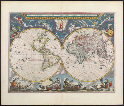
Joan Blaeu's Remarkable World Atlas

Joan Blaeu produced a remarkable 11 volume atlas between 1662 and 1665. It was the largest book published during the 17th Century. 
These volumes were meant to be the first part of a larger series. The title translates to "Grand Atlas or Blaeu's Cosmography, in which are most accurately described earth, sea, and heaven" with a second part about the oceans and a third about the stars. However, he did not live long enough to publish those volumes.

This summer I went to the Osher Map Library in Portland, Maine to see their Pictorial Maps exhibit (see my previous blog post for a review.)  The first map in the exhibit though not "American" or part of the "Golden Age" was from this atlas and meant to show an early use of pictorial decorations on maps.
http://oshermaps.org/map/458
While I was there, they let me look at a volume of this atlas. I chose the first volume and took pictures of various pages, including the map above (though the image from Osher shown above is much better than my photo.) It was an amazing experience to hold a volume of this atlas in my hands. Unfortunately between the lousy notes I took and my lack of knowledge of Latin, I don't have much to add to the photos I took - here they are.
From the Introduction - the orbit of the known planets, going out as far as Saturn.
The first volume is mostly focused on the Arctic regions. Above is the island of Spitsbergen, below is the adjacent island of Jan Mayen with some great (and probably very exaggerated) details.
More easily recognizable to most people, Iceland.
In addition to maps, the atlas has some great pictorial details including this Walrus illustration,
and whatever this totem is. If I could read Latin, I might be able to figure it out. Note: see comments for a good explanation.
There are also details of buildings and other public and religious spaces. Again, I don't know what we're looking at here.
UPDATE: Reader Ted Kottler has identified this as Tycho Brahe's observatory on the island of Hven (aka Ven), Sweden in the Oresund, the strait between Sweden and Denmark. 

I'll finish up with one more map. After much curiosity and digging around, I figured out that the map below is part of the Nordfriesland district in Schleswig-Holstein, northern Germany along the border with Denmark. I'm still not sure what the underwater streams are - some elaborate planned land reclamation, ocean drainage project?
Once again, I would like to thank the kind and helpful staff at the Osher Map Library for allowing me to see and hold this atlas. Though the pictorial map exhibit is over, there are still lots of great things to see there.

Wednesday, September 21, 2016

Map Your Mind

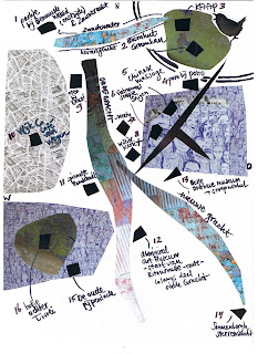
Map Your Mind collects personal stories and memories of Utrecht in the Netherlands. People are encouraged to sign up, create a hand drawn card and share it with others.
http://www.mapyourmind.nl/map/t/sanne/
Maps are annotated with personal observations and artistic or local details
http://www.mapyourmind.nl/map/t/sanne/
Most are geographical representations with varying degrees of abstraction. The map above focuses on artistic representations of the Oudegracht Canal and various streets. The map below is a fairly accurate geographic representation of the canals, streets and railroads of central Utrecht. User Hannet has a good sense of geography.
Whereas De Map van Debbie is just an annotated Google map.

On the other hand some cards are not maps at all.
http://www.mapyourmind.nl/map/t/lara/
Contributors are encouraged to put a short legend below explaining the locations. The stories and explanations really help give life the maps.
http://www.mapyourmind.nl/map/t/anna/
 Some users like Jaap, however, prefer to let the map speak for itself.
These are fun to look at - the list of "mappen" can be found here.

Wednesday, July 1, 2015

10 More Maps That Won't Change Your Anything!

They just keep coming! A constant stream of clickbait about how a series of maps will change your life, make you think differently, increase your earnings, and help you finally get that promotion. OK, perhaps the latest version is a bit more modest seeking only to "teach you something new about the world" - though the merit of knowing how to say "bear" in different European languages is debatable.

Here we attempt to free you from the burden of such claims. Like a good summer read, here are some maps that are unlikely to change your life but you may enjoy them just the same.
  
1. Map of the Detroit area on a Motown single
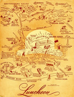
2. Map from a menu of the Brown Derby, Los Angeles via The New Yorker
http://www.newyorker.com/culture/culture-desk/chronicling-los-angeles-history-menu-by-menu
3. Map of Heisenberg - a fictional city based on Breaking Bad
http://akidwell72.wix.com/visitheisenberg
4.  Map of Albuquerque - an actual city based on Breaking Bad
http://tomlambmaps.tumblr.com/post/113535321000/breaking-bad-map-by-tom-lamb-in-albuquerque-nm
5. Historic map of the Black Swamp - from a Toledo Bellows article about the Black Swamp Underground, a Toledo area musicians' collective.
6. Tourist map of the Hague by Zara Picken.
http://zaraillustrates.tumblr.com/post/47696751349/i-was-commissioned-by-homes-antiques-magazine-to
7. Manitou Springs, Colorado where I had an excellent breakfast once. From the Colorado Springs Gazette, 1922.

8. The Beatles Map, 1974. Click the image for a more legible version.
 http://www.theguardian.com/books/gallery/2014/nov/04/a-history-of-the-20th-century-in-100-maps-in-pictures#img-8
9.  Interactive map of El Gouna, Egypt.
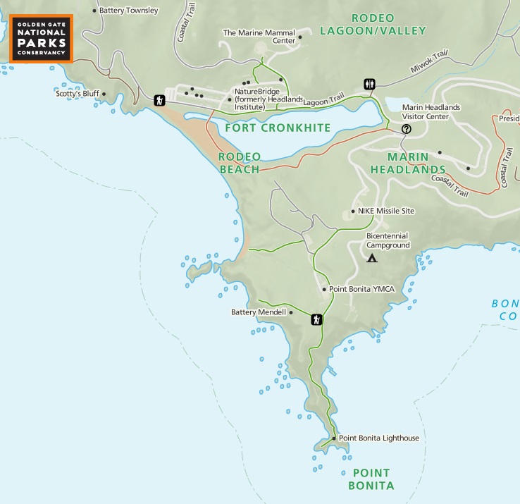
10. Online map from the Golden Gate National Parks Conservancy