Showing posts with label saskatchewan. Show all posts

Wednesday, April 22, 2026

Ethnic Diversity of Toronto

 Jeff Allen is a cartographer based at the University of Toronto and does work for their School of Cities. He’s created some interesting visualizations, particularly around language. Here is a page where you can choose from dozens of languages to see how their speakers are distributed across the Toronto and Hamilton metropolitan areas.


Above I’ve chosen five languages represented in different colors. While French and Spanish speakers appear to follow overall population trends (no obvious clusters) there are very clear clusters for Mandarin, Punjabi and Italian.

I tried a few random smaller languages to see if they had their own clusters, which they do. Khmer and Lao speakers cluster in the same Jane Street area while Yiddish (and Hebrew also) cluster along Bathurst Street. 


Another visualization traces the history or ethnic groups. Choose from over 20 languages and you get a scrolling story showing the distribution changes at various time periods going back to 1971 .

Here is Yiddish, showing the same pattern as in the previous map.

Branching out to other cities this visualization shows the English-French east-west divide in Montreal. The purple areas are the most bilingual, while yellow areas are where immigrants live and are less likely to speak either language.


You can see many more of his maps here.

Back to Toronto, here is a gorgeous, colorful map by Alex McPhee showing the most commonly spoken non-English languages across the city. The “small multiple“ maps across the bottom, showing the top languages are a nice touch. 


He has produced similar maps for Montreal and Saskatoon.


I’ll close with one more Jeff Allen map: Dogs of Toronto.


Wednesday, May 17, 2023

The Alphabet Railway

Radio personality Bill Barry was fascinated with the place names of his native Saskatchewan. So much so that he wrote a Dictionary of Saskatchewan Place Names, I'm sure you've probably read it already but an interesting item about this toponymy is how many of the towns were originally named by the powerful railway companies. The Grand Trunk Pacific Railway began naming its sidings in alphabetical order starting in Manitoba and going through the alphabet three times. Here is part of a map from Barry's book, via the Prairie Fiddler. Click to see the entire map.

You can still see the pattern in today's place names. Here's a section via Apple Maps going from Venn to Zelma then continuing with Allan, Bradwell and Clavet.

Their are interruptions for pre-existing towns or other anomalies such as Nokomis but otherwise it follows pretty well. Here is a detail of the above section from an old RandMcNally map showing a place called Xena between Watrous and Young.

Wednesday, May 16, 2018

Canadian Checkerboard - Part 3

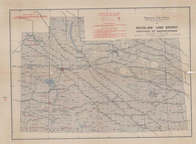
Here is my final Canadian Homesteading map. Moose Jaw Land District.
It is not as colorful as the Northern Alberta map but is similarly effusive about the quality of the land.
Like the previous map each grid cell is a square mile section.
There is not much topographic change here so the "mountains" really stand out.
This map was accompanied by a Saskatchewan Railway Guide
One of the interesting things about this is the ads along the edge for sheaf loaders, livestock brokers, mattresses and overalls.

The back of the map has a yellow detailed map showing ownership of quarter sections around Hodgeville. 
 The apparent purpose of this map is to advertise gopher poison.
 "$276,000 worth of grain sown on the land in this map was destroyed by gophers. My own Gopher Poison will save this year's crop. Get a package either from your council or dealer. Cheapest poison obtianable when you count results. Made only by ANTON MICHELSON COMPANY, Ltd, Winnipeg."


Wednesday, April 25, 2018

Canadian Checkerboard - Part 1

In the past year I've accumulated dozens of maps. A friend had grandparents who tried homesteading on the Canadian Prairies and gave me some remarkable maps showing lands that were available via the Dominion Lands Act. Here is a 1917 map showing lands in Manitoba, Saskatchewan and Alberta.
The map is 3 ft x 2 ft. I was able to scan it at a high resolution. Here are some readable details.

The Dominion Lands Act of 1872 was based on the Homestead Act in the United States. Square shaped 160-acre parcels of land (much of it taken from indigenous tribes without compensation) were made available to settlers in return for a small registration fee. They had to establish farms and build permanent dwellings in return. Immigrants from Europe were encouraged to settle on these lands, partially out of fear of the United States (where most of the good land had been taken by then) trying to lay claim to them. Some of the land was set aside for soldiers.
http://www.collectionscanada.gc.ca/obj/021017/f1/c126302k-v3.jpg

Red numbers indicate the number of quarter sections available in each 6 x 6 mile township. The green area is Palliser's Traingle, an arid region where exemptions were made so farmers could buy adjacent lots and double the size of their homesteads, increasing their chances at successful agriculture.  Railroad companies owned the land within 20 miles of their tracks so townships adjacent to the tracks had no numbers while nearby ones had smaller numbers. Here is the legend.
I'm not sure what part of the act was discontinued or what "O. in C." refers to.

For contrast here is a more sparse area along the Peace River in northern Alberta.
I have more of these maps and will show them in another post or two. Stay tuned!

Wednesday, November 18, 2015

Canada's 1955 future

Macleans magazine bought this map from the Canadian government. It is from 1955 and details "100 Important New Resources That Will Help Make Canada's Future Bright And Prosperous" - 1950's booster-ism at its finest.
http://www.macleans.ca/news/canada/1955-map/
Here is a close-up view showing details such as petro-chemical and nickel leaching plants near Edmonton, a nationwide microwave net for TV, far-reaching rural electrification, gas turbine locomotives and a money tug of war with the United States.  
Sample text from the title block
"Yesterday many of the places shown here were barren rock, desolate tundra or virgin forest. Tomorrow they will pour out a swelling flood of nearly all the materials needed by modern man...."
I'm not sure if the colors (green, yellow and red-ish) mean anything (elevation?) or if that's just an artistic effect. Also, the leaf-like channels within the Great Lakes are a strange touch.

The Macleans article has a nice selection of items from the map showing which predictions were good (tar sands oil) and which were overly optimistic (potash.) Some other interesting items not covered in the article:
  • "Flying laboratory” carries ½ ton of electronic equipment in simultaneous search for many minerals.
  • Latest rust-resistant wheat developed at government lab in Fort Garry, Man.
  • Continent’s first turbo-prop airline service.
  • 2,250-mile gas pipeline from Alberta to Toronto-Montreal at cost of $300 million.
  • 19 new river valley conservation programs in Ontario.
  • $60 million for world’s largest transatlantic telephone cable built by Canada, U.S.A., U.K.
  • Atomic reactor at Chalk River for research into peaceful uses of atomic energy.
 I included that last item because I spent time in Chalk River as a graduate student and got to know some of the nuclear plant workers.

A complete list of all 100 resources can be found here, while a larger version of the map is here.


Thursday, March 29, 2012

Random Thursday-Maps You Probably Won't Use Today

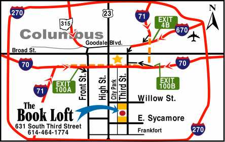
Have I mentioned that I don't really care for google (or bing or yahoo) maps? Sure they serve certain purposes very well and I even use them at work when they fit the bill. However, when directing me to your business I prefer a customized map. Here are some examples.

A map to the Kipu Ranch on Kauai where you can enjoy scenic beauty by ramming through it on an ATV.
Directions to Camp del Oro in Nevada City, California. You will probably get lost.


Raffles, an Asian restaurant in Nagoya, Japan. An Asian restaurant in Japan? What an idea!


The Book Loft of German Village - Columbus, Ohio. Absolutely not to scale but emphasizing the important details - and you can't do that in google!


Pasquia Regional Park in Saskatchewan- looks like it was drawn by a kid with cartographic skills.


A very red map of the locations of the Big R Stores in the Northwestern US. I love how the topography ends at the Idaho border!

Here's a map to The Strand - a development in Datarang Sunway, Malaysia. I got the image from Three Meals of Goodness, a Malaysian dining blog. I like the exaggerated earth curvature, and the Ikea.