Showing posts with label syria. Show all posts

Wednesday, February 15, 2023

Turkey and Syria Earthquake Response

Parts of Turkey and Syria have been devastated by the strongest, most destructive earthquake in the recorded history of those countries. The earthquake has been followed by over a hundred powerful aftershocks, including one almost as powerful as the original magnitude 7.8 quake.

Map via Ajazeera

One of the many problems hampering response is the lack of adequate mapping in many of the areas. While many high profile large buildings have collapsed there are also buildings that are not mapped and those can get missed by response teams. The Humanitarian OpenStreetMap team is recruiting volunteers to help locate buildings and streets via aerial and/or satellite images. No experience or travel is needed, people can do this work at home. This map via Twitter shows (in the text box) the percentage of and number of buildings and streets mapped in each area. It also identifies where mapping needs are most urgent. The buildings in light blue unfortunately cover up the other information on the map.

If you want to help map these areas you can go to this task.

Tuesday, May 24, 2016

Lady Anne Blunt in Northern Arabia

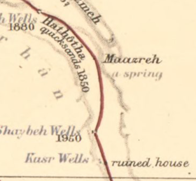
In March the Library of Congress posted a series of maps for Women's History Month on their geography and map blog. Their last post was a map showing the journeys of Lady Anne Blunt through northern Arabia.
https://blogs.loc.gov/maps/2016/03/lady-anne-blunt/
Blunt was a British noblewoman who was famous for helping to save the purebred Arabian horse by buying and bringing horses to England. She was the first European woman to cross the Arabian desert in pursuit of these horses. As an interesting side note her mother, Ada King-Noel, Countess of Lovelace is often regarded as the first computer programmer.

Blunt was not a cartographer but her place-specific descriptions of two journeys, in 1878 and 1879, allowed Edward Stanford, a London bookseller and mapmaker (creator of Stanfords Travel Guides) to create this remarkably detailed map.  It shows not just the physical geography of the land, but cultural features such as irrigation and grazing practices, tribal relations and pilgrimage routes.
Here are a couple more zoomed in views.

You can browse and/or download the entire map online at the Library of Congress.

Wednesday, December 11, 2013

The Islamic World

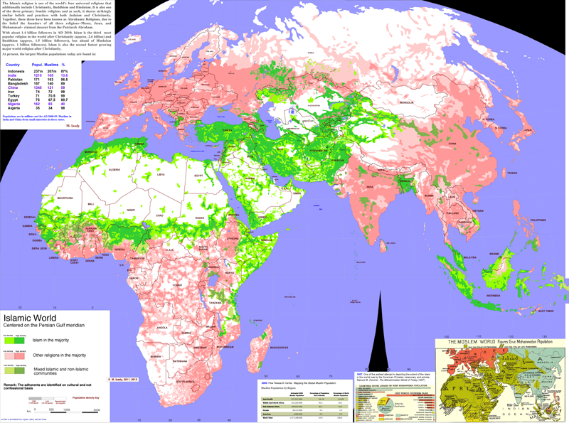
Columbia University's Gulf/2000 Project was created as a service to scholars, journalists, politicians and other professionals working in the Persian Gulf region. The web site for this project contains some fantastic maps created by Dr. Mehrdad Izady showing population, religion, language and other divisions that affect the region.

His large map of the Islamic World is particularly striking. Many of the recent conflicts in the world have occurred along the boundaries of Islam and other religions such as in Mail, Nigeria, Central African Republic, Sudan/South Sudan, the Caucasus region and in parts of India and Pakistan.
http://gulf2000.columbia.edu/images/maps/Islamic_World_Basic_lg.png
The lower right corner of the map contains a 1907 map depicting the extent of the "Moslem World." The overall pattern is largely the same as today.

"Syria Ethnic Composition" is another very detailed map showing how diverse that country is. The text on the right describes how much of this complexity is lost when language is considered the defining ethnic characteristic. The commonly used "Arab" ethnic stamp glosses over these divisions but the current conflict in Syria has shown their significance. 
http://gulf2000.columbia.edu/images/maps/Syria_Ethnic_Detailed_lg.png

The maps page has many other highly detailed maps not just of the Gulf region, but the entire Middle East as well as parts of Africa and Asia. You can spend hours looking at these. I did. 

Thursday, January 3, 2013

Mapping the Evolution of Stories

A few years ago Lapham's Quarterly mapped the evolution of four famous stories; Pygmalion, Faust, Oedipus and Leviathan. These stories all originated in the eastern Mediterranean region (modern day Turkey, Syria, and Libya), spread their way through Europe and eventually made it to the United States where they were all Hollywoodized, or otherwise Los Angelified. In each case the story has been modified but with the exception of Pygmalion, most have stayed fairly true to the format of the original.

This map is big and hard to see in much detail here (a click will take you to the original) so here is a detailed view showing the origin of each story.


Wednesday, October 24, 2012

Etch a Sketch Maps

There's been lots of talk about Etch A Sketches in our current presidential election. Those of us in Massachusetts have a long history of watching Governor Romney shake that thing clean.

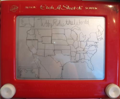
I was looking at something completely unrelated to politics, maps or vintage toys when I came across some wonderful examples of etch a sketch art, including a few maps. Here is the USA, from ivman's blague. This is supposedly from a young child and has a caption of "Tubby_Rules_the_World" - yes all the words have to be connected.


Africa:


Of course, there's an app for this. Here is a world map from the Etch a Sketch Mobile app. Yes the Mercator Projection continues its dominance in the field, pleasing the residents of Greenland.


Romney may want to study this world map after his statement in Monday's debate about Syria being Iran's route to the sea - as if they need one. There's a little problem called Iraq in between. Note all that blue stuff at the bottom of Iran. Picture form the Daily Banter.