Showing posts with label new england. Show all posts

Wednesday, August 7, 2024

Summer Light Reading 2024

Here is another installment of what is becoming an annual summer tradition. Just like the light beach reading, here is some light map reading. Not much to comment about, just some maps and related items I like.

First of all since the Olympics are in Paris, a nice papercut map you can enjoy, or buy here.

A very colorful map from Wikimedia Commons showing the different sections of the Rhine River. As one reader pointed out it looks like a water quality map and probably is as river quality tends to get worse as more cities and farms downstream dump pollution into them.

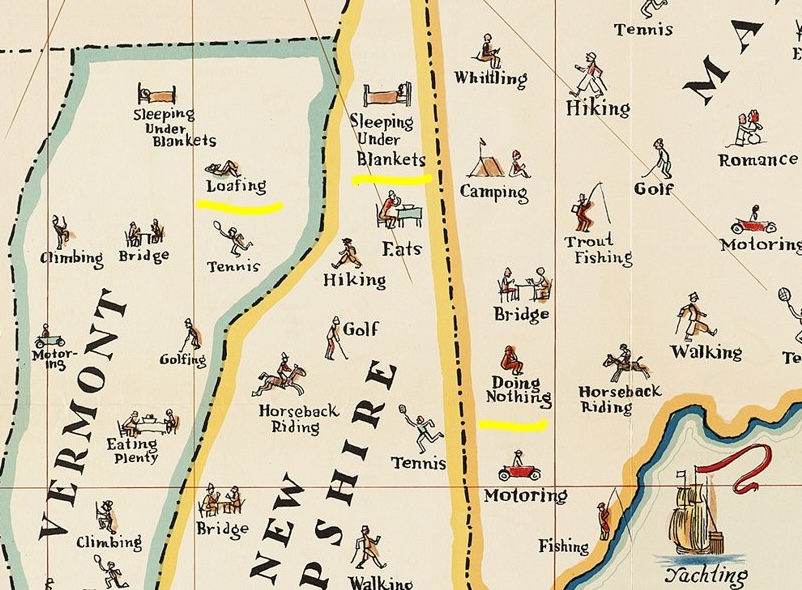
A map of things to do in New England. I copied a portion and highlighted some of my favorites such as "loafing", "sleeping under blankets" and "doing nothing".

Transit map of Kaohsiung on Taiwan. There are some great station names like Dream Mall, World Games and Oil Refinery Elementary School.

A screen shot from Yahoo Japan that I like for no specific reason.

Finally, Tsunami Generating Earthquakes. I think this originally came from some social media site that was once known as Twitter. Maybe from the U.S. Geological Survey.

OK, back to your beach read.

Friday, February 8, 2013

Purple is the New Scary

With winter storm Nemo* bearing down on us the weather cartographers have decided that purple is now the scary color. Kind of like the recent Australia maps except this time indicating snow instead of heat.

Maps are from The Weather Channel. Apparently oblique is now the scary map angle. Working in the "Action" zone, I just set up our town's emergency mapping function - sounds more exciting than it really is.
So hunker down and buy all the bread and milk you can find, it's going to be a purple day for many of us. 

* Since when do they name snow storms? It used to always be the Blizzard of (Insert Year Here.)

Thursday, September 15, 2011

Bonus Tropical Storm Coverage

From NASA's Earth Observatory page:


Nearly a week after Hurricane Irene drenched New England with rainfall in late August 2011, the Connecticut River was spewing muddy sediment into Long Island Sound and wrecking the region's farmland just before harvest. The Thematic Mapper on the Landsat 5 satellite acquired this true-color satellite image on September 2, 2011.

It's also interesting to see the comparison of the Connecticut with the Thames River. When I first looked at the image, I assumed that there was less sediment from the Thames because its drainage area received less rainfall but that's not the only reason:

To the east, the Thames River appears to be carrying very little sediment at all on September 2. According to O'Connell, the Thames "drains glaciated terrain, so fine sediment was removed long ago." Most of the land surface in the Thames basin is "just bedrock, till, and glacial erratics." Unlike the Connecticut, areas within the Thames watershed only received 2 to 4 inches of rain in most locations.

Wednesday, October 31, 2007

Map of the Week #98 - The Vermont Foliage Cookie

My wife bought a Vermont shaped cookie cutter and as we were making Halloween cookies last night I tried to color mine along the lines of the foliage maps that we had seen in the newspapers up there a few weeks ago. While it did not match the state's tourism web site animation very well, it did come somewhat close to the September 25th foliage map on the bottom right. In fact it was close enough that Amy was able to guess what the map was showing on the first try.


Thursday, August 9, 2007

MOTW #87

These maps are "wind speed grids" for New England. The heights (30m, etc) in the upper corners are the height at which the wind speeds were measured. This study was done by Truewind Solutions to get an idea of how much wind power can be derived from wind turbines of different heights and locations.
If you really want the whole in depth analysis you can go to the Mass. Technology Collaborative and get a detailed wind map for areas within souther New England.

Thursday, March 15, 2007

MOTW #68

This past weekend I did lots of traveling in circles around the Northeast using all kinds of transportation modes. During one of the long rides I decided to see what it would look like to map out my travels so here's what I came up with. Well, it's sort of vaguely interesting anyway. Note that the walking distances are slightly exaggerated (but not by much) - otherwise they'd be invisible at this scale.