Showing posts with label st paul. Show all posts

Wednesday, October 21, 2020

What Can We Learn From Orientation

This week's popular distraction on the geo-webs is an app that draws every street in a city (or other location) colored by orientation. Here is one of my favorite personal places, Philadelphia.

While seemingly just a meaningless distraction the colors do tell you something about settlement patterns. Settled on a part of the Delaware River that runs due south and then west, the major part of the city is along an almost north-south (red) grid. However most of the river flows at about a 45 degree angle and much of southeastern Pennsylvania is on a grid shaped by the river's direction (the purple and blue lines). In the outer parts of the city these grids collide creating some of the more interesting urban spaces in the city (IMHO). Here is the southeastern part of Pennsylvania. I expected to see more purple but there is still quite a bit in the northern regions of the metro area where I grew up.

Note that the app allows you to change the background color. For most of these images I set it to black because the roads show up more clearly. 

For a more meta view here is all of Pennsylvania.
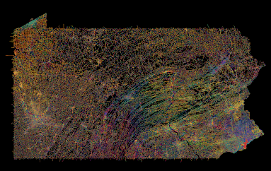
I do not recommend loading an entire state as it takes a while and may overwhelm your computer (and their server).

Points of interest include the colorful twists and turns of the central valleys and ridges, the separately unique Lake Erie grid, and the holes in the northern forests where no roads run. As a different type of city Pittsburgh, one of the toughest cities in the country to navigate, is quite colorful. There are still many grid neighborhoods but they run at all kinds of angles, often at the whims of the rivers.
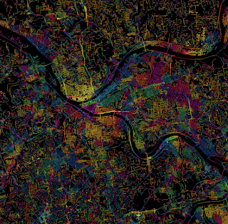
Pittsburgh-taste the rainbow!

For a suburban view, here is the area around my childhood home in Levittown, PA. The blue lines in the upper left corner are from a shopping mall parking lot.

Many cities in the western half of the United States strictly follow the township and range grid of the public land survey system. Often the downtown areas run at an angle either to follow a railroad or to accommodate an older grid system. Here is Denver. 

Denver-embrace the yellow!
As a proof of concept here are four other cities with a similar pattern.

I could go on about this for way too long but I'll end with an artistic mashup of some of the more interesting and colorful places I've explored in Philadelphia. You can explore you favorite places here.
 

Clockwise from top left - the art museum area, the effect of the Schuylkill River bends, roads curving around the airport runways, the way Roosevelt Boulevard breaks up the northeast grid, some curvy suburban colors, and a difficult to see Logan Circle.

Wednesday, September 7, 2016

The Seven Hills of Everywhere

Rome was built on seven hills. Here they are (the ones inside the city walls):
http://octavianchronicles.com/wp-content/uploads/2014/11/RomeColor730rev7.jpg

Many other cities decided that they wanted a piece of Rome's glory and created their own seven hills legends. Here is Wikipedia's extensive list of cities claiming to have seven hills. Of course the nature of hills make it easy to cherry pick various topographical features to come up with seven hills, and also to dispute those claims. Cincinnati seems like a good example of a city that's trying too hard to arrive at exactly seven hills.
http://www.diggingcincinnati.com/2014/03/cincinnati-city-of-seven-hills.html
Also cities tend to expand to include more hills and many of the original ones have been leveled. Here is a collection of various seven hills maps for your reading pleasure.

Jerusalem - they had seven hills long before Rome. Here is a sketch showing seven hills within the old (third) city wall 
http://www.centuryone.com/images/exploredjerusalem.jpg


One of the first cities to jump on the seven hills bandwagon was Constantinople (Istanbul) - here is a map from the Hebrew wikipedia. The hills are numbered but not named.
https://commons.wikimedia.org/wiki/File:Seven_hills_of_IST.png

Rome, Georgia - if you're going to name your city Rome, it might as well have seven hills.
https://en.wikipedia.org/wiki/Rome,_Georgia#/media/File:Rome_Georgia%27s_7_Hills_and_3_Rivers.png


Richmond, Virginia took the extra step of listing their seven hills in a 1937 ordinance. The goofy colored triangles represent "official" hills. Several other gray triangles shown are "unofficial" hills. The far west hill is called "Oregon" because that's how far west it seemed to the rest of the city at the time. The complete list is here. You can explore them interactively here.
http://www.rvabusiness.com/2012/06/28/the-seven-hills-of-richmond/


St. Paul, Minnesota - they can only agree on five of them, and some of them are really just bluffs rising up from the river. A full accounting of them can be found here.
https://www.minnpost.com/stroll/2015/07/st-pauls-7-hills-there-seems-be-agreement-5-them

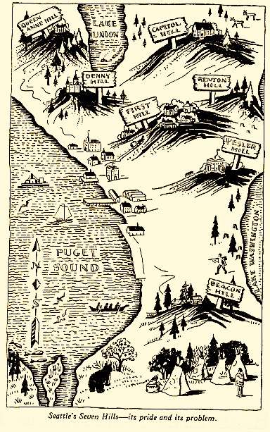
Here is a nice map and description of Seattle's seven hills...
http://geologywriter.com/blog/seven-hills-of-seattle/
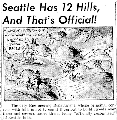
... except maybe there are really twelve?
http://geologywriter.com/wp-content/uploads/2014/10/Screen-shot-2014-10-20-at-6.01.07-PM.png

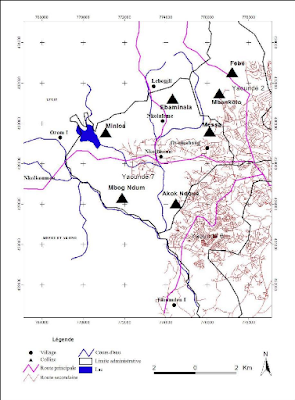
In Africa, Yaoundé, the capital of Cameroon is known as La Ville aux Sept Collines (city of seven hills)  - all of them are on the west side of the city.
http://www.memoireonline.com/01/13/6854/Anthropisation-et-risques-environnementaux-sur-les-collines-de-Yaounde16.png

Thiruvananthapuram-capital of Kerala Province India
Maybe not. The Hindu (souurce for this graphic) says "if we start counting the hills in the city, it becomes confusing. Hills there are, but to decide on the seven that the city rests on, is near impossible. The really high hills are outside the city."

Near me Somerville, Massachusetts claims seven hills and has a park devoted to them with cute towers marked for each hill.
https://summerinsomerville.wordpress.com/tag/seven-hills/
I was unable to find a good map of the seven hills so I made my own hand drawn one. Enjoy!

Wednesday, August 5, 2015

A Compendium of Hand Drawn Goodness

Frome County, Nevada (fake county) - from the Wild West, war game by Wassail Beagles
 The Town of Steaming Rock (fake town) in Frome County, Nevada
http://www.iandrea.co.uk/wargames/resources/Steaming_Rock.jpeg
Map to the StrikeKing Bowling Alley in Mishor Adumim, an Israeli settlement east of Jerusalem.
http://www.jr.co.il/ma/map-mishor01.htm

Nancy Chandler's Bangkok Map 
http://www.nancychandler.net/bangkok.html
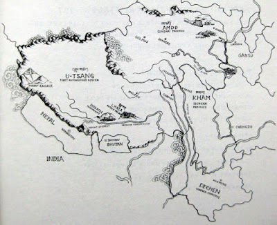
Traditional Regions of Tibet - via Tibet Insider
http://blog.snowliontours.com/wp-content/uploads/2010/04/IMG_7120.jpg

Essaouira, Morocco
http://www.handmaps.org/recent.php?ID=178

101 Dalmatians Map
http://londonist.com/2011/11/hand-drawn-maps-of-london-101-dalmatians-walk.php
Maycomb, Alabama Harper Lee's fictional town from To Kill a Mockingbird and Go Set a Watchman
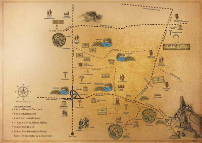
 Sobha City - a Mediterranean themed community outside of Bangalore, India - located about here
http://www.99acres.com/customised/sobha-city-hebbal-ring-road-bangalore-residential-property/gifs/sobha-city-hebbal-ring-road-bangalore-residential-property-location-map.jpg
Garrison Keillor's "Memory Map" of the Twin Cities - via National Geographic