Showing posts with label san diego. Show all posts

Friday, November 19, 2021

Thirty Day Map Challenge - Part 2

Here are the next batch of maps I've posted for the #30DayMapChallenge. The first ten maps are here.

Day 11 - Theme: 3D

For the 3D theme I attempted to recreate an exercise from my first cartography class back in the 1980's. That exercise was done using a pencil and graph paper. Unfortunately, I do not have my notes or remember the exact procedure. I did this one using GIS software instead. The map shows murder rates by state. Back then North Carolina was #1, now it's Louisiana. The map is "upside down" so that the higher southern states don't block the view of the lower northern states.

Day 12 - Theme: Population

This is a map of Arctic settlements done "firefly" style, which is fashionable these days in cartography circles.

Day 13 - Theme: Data Challenge 2: Natural Earth

Natural Earth is a set of publicly available data. It is a collaboration involving many volunteer NACIS members and cartographers around the globe. Nathaniel Vaughn Kelso and Tom Patterson led the effort. They have produced some beautiful topographic images of the world. The map was also inspired by a NACIS talk on indigenous place names. The topography and streams are from Natural Earth, while the place names came from Canada's Open Data site.

Day 14 - Theme: Map with a new tool

This one is a bit of a mess because I started doing a tutorial using R, a new tool for me, but I ran into some technical difficulties and then ran out of time. I never expected that Sunday, a non-work day might be the day that I run out of time. I had seem some recent Excel maps and made a blog post about this one. At the last minute decided to try one. Last Spring I tried my hand at a cross stitch map of Rochester, New York. This seemed like a natural fit for an Excel map since it is very grid-like. Instead of doing land use though, I tried doing one of those HOLC redlining maps from the 1920's. 

Lack of time forced me to go very low res. so the map ends up looking like not much at all.

Day 15 - Theme: Map made without using a computer. 

Several of the previous maps were hand drawn but I decided on a different approach here. This is a souvenir Pennsylvania cutting board stacked with coins representing the GDP of the metropolitan areas of the state. One cent = $1 Million. It's a nice, even formula but does not make the stacks high enough to really show the pattern well. Since it is helpful to see multiple angles, I created this mediocre video.

Day 16 - Theme: Urban/rural

This was mostly just an exercise in image manipulation to tease out the urban and rural areas by land cover. I picked Charlotte after looking for cities that might have an interesting looking pattern.

Day 17 - Theme: Land

While waiting in the San Diego Airport a few years ago, I noticed a display of Kumeyaay culture. I was unaware of these people as I suspect many are. There were a couple of maps which I later found copies of on a website dedicated to Kumeyaay culture. I find it interesting that their territory predates the US-Mexico border which has been imposed on their land. This is what the area looked like pre-border.

Day 18 - Theme: Water

This was just a fun exercise in grabbing some water data from northern Quebec and overlaying it on top of a cheesy tree pattern that I made just for this purpose. More art than map. The large lake in the west is Lac Couture, an impact crater.

Day 19 - Theme: Islands

I've always been fond of Christo and Jeanne-Claude's Surrounded Islands installation so I decided to map it. Buffering is one of the most common and basic GIS functions (ie. is this property within 200 feet of the river?), here was an example of a real world buffer.


More to come (I hope).

Wednesday, August 28, 2019

Getting Personal at the La Jolla Map Museum

For a final post of my Spring visit to the La Jolla Map & Atlas Museum I want to spotlight a few maps that are interesting to me for various personal reasons.
Photo courtesy of the La Jolla Map & Atlas Museum
This map by William Faden shows the movements of George Washington's troops against the King's army in New Jersey in 1776 and 1777. Faden's 1777 map of Philadelphia hangs on my wall and part of it appears on the header image at the top. The New Jersey map has lots of bits of historical information but this less important detail in the southwest corner is what interests me the most.
My childhood home is at the bottom of the map, just a little south and east of Middletown (now Langhorne, but the surrounding area is still Middletown Township). We would often take the drive to Newtown to get ice cream and visit the stores. It was a nice country drive to a nice little town. Newtown is still a quaint olde towne but is now surrounded by a partial beltway and a sea of ugly (IMHO) housing developments. I like seeing this view of Pennsylvania before runaway development.

Woodblock map of Edo (Tokyo) ca 1840 from the Shogun period.
Photo taken at the La Jolla Map & Atlas Museum
I have always been fascinated with Japan and especially Tokyo. I also love woodblock maps and all the tiny details found within them.
There is a detail page on this map on the museum's web site.

I took this photo and then rotated the map, out of habit of wanting to see north up. The map is actually reverse "oriented" with west at the top. My rotation was a kind of accidental mistake but I've left it this way because it fits the blog dimensions better. Here is the description from the museum's page.

"beautiful woodblock map of Tokyo from the golden age of Japanese woodblock map printing. Combining the elements of traditional Japanese map-making: rice paper, woodblock printing, delicate application of colour, the inclusion of topographical views into the map proper, and all text seems to radiate from the centre of the map; with a more modern western-influenced directional orientation with north to the right of the image. "  
Here is a bird's-eye view of Avalon on Santa Catalina Island in southern California. I've never been there and I don't know exactly why this map speaks to me. It just looks like a warm, welcoming town nestled in among the mountains - probably with crazy high real estate prices.
Photo courtesy of the La Jolla Map & Atlas Museum
Downtown detail.
The map is surrounded by images both real and fanciful of seals, buffalo, mermaids and people having all kinds of recreational fun. Here is one showing the road signs.
This last item is of interest due to its uniqueness. It is a display case used by Folsom Brothers to sell real estate in San Diego.
The case folds closed like a suitcase to carry around. The map is a relief map showing the topography in detail.
Here is the handle just west of Point Loma


Tuesday, June 11, 2019

Pictorial Maps from the La Jolla Map Museum

In one of my final posts from my March visit to the La Jolla Map & Atlas Museum, I will show some of their large collection of pictorial maps. They just opened a new room dedicated to these maps including many by Jo Mora, an artist and photographer originally from Uruguay who moved to California, the subject of many of his pictorial maps.
Photo taken at the La Jolla Map & Atlas Museum

Photo taken at the La Jolla Map & Atlas Museum
More on the map above can be found in a previous post.

Another popular collection of pictorial maps is the "Hysetrical Map" series by the Lindgren Borthers.
Photo taken at the La Jolla Map & Atlas Museum
This one is titled "A Hysterical Map Of The Mother Lode Where California Was Born and Hell Was Raised." It's full of jokey details such as "Gold is often found in sand but so is spinach" and "An ass covered with gold has more respect than a horse with a pack saddle." There are also maps of Yellowstone and the Grand Coulee Dam featured on the museum's web page.

A 1963 tourist map of southern California grandiosely titled "Ride the Roads to Romance along the Golden Coast thru the Sunshine Empire of Southern California" shows historic trails emanating out for Los Angeles City Hall,
Photo courtesy of the La Jolla Map & Atlas Museum
to charming mountains, orange groves and historic missions.
Photo courtesy of the La Jolla Map & Atlas Museum
The edges of the map show natural and historic vignettes.
Photo courtesy of the La Jolla Map & Atlas Museum
Harrison Godwin's 1927 map of San Francisco ("where the sun never scorches and the water never freezes") is one of the most detailed pictorials packed with facts, figures, "whimsical vignettes" and transportation info.
http://lajollamapmuseum.org/maps/map-san-francisco-showing-principal-streets-and-places-interest
I was not able to get a good up close photo but here is a screen shot via the David Rumsey Map Collection.
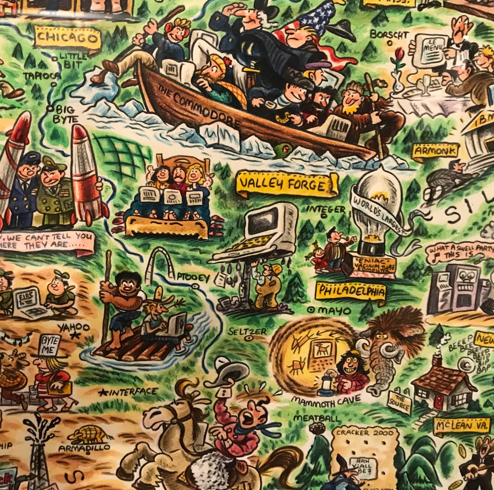
For a slightly more "modern" take here is the "Digital Deli Map of Personal Computer America" by illustrator Rick Meyerowitz, most famous for his work for National Lampoon. The map highlights Silicon Valley culture.
The bottom of the map contains a list of highlighted companies.
Highlights include a hiker in the Cascades carrying a large PC on his back with the screen reading "You are lost" and people in hot tubs looking at their computers. Here is part of the less important and therefore compressed eastern two thirds of the country.


Thursday, March 21, 2019

A Visit to the La Jolla Map Museum-part one of many

On Saturday I had the opportunity to visit the Map and Atlas Museum of La Jolla. The Museum hosts the impressive collection of Michael R. Stone. In the coming weeks, off and on, I will be spotlighting some of the more interesting (to me) items I saw there. For now here is a brief preview. These are my own photographs so they are a bit out of focus and may have light reflections.
Palestine from Rudimentum Novitorum, 1475. This book is considered the first world chronicle. It combined geography with myth. The maps, made from woodcuts and colored by hand show countries and regions as hills. The geographic positions are more relative than accurate. 

Astronomical calendar from the cloister of San Zeno in Verona ca. 1455. Three dials can be rotated to line up months, days and moon phases. It helped monks organize their devotional schedule, including figuring out the date for Easter, a moon phase based holiday - more details here.

Pictorial map of San Diego, 1928 by Jo Mora. "This limned Carte portraying with the most exacting fidelity the History, Romance and Humour of the glorious City of San Diego by the Pacific, likewise showing the Noble Harbor and its surrounding Terraine...." Created for the Marston department store's golden (50th) anniversary.

Wednesday, April 5, 2017

Grand Theft Auto

I'm not much of a video game player so my ignorance of these things will be pretty obvious to the average gamer. Many video games have cool maps. What's interesting about the geography of Grand Theft Auto is that it is only sort of fictional - the names are different but the places are obviously recognizable. Here is a user created map of San Andreas created by Brazilian user DaniLekBom.
http://gtaforums.com/topic/447751-gta-mapmaking/page-124#entry1069187250
Names like "San Joan" and "Oakplace" are pretty thinly disguised. I like how he squeezed "San Donado" down at the bottom. You can just about see where the ESRI user conference takes place.

There's also a city in the desert. It's called Las Venturas. It has a strip! What was that inspired by? A couple of mysterious places inland like Endsville, Grapeseed and Coconut Springs have less obvious corollaries.

Vice City is another common locale in the game. Sometimes referred to as Vice-Dade County as if it wasn't obvious enough where it is.
http://i.imgur.com/iP2ZiDa.png
Liberty City is also a very familiar looking place. Here's a nice map of it. Lots of green spaces - including a largely empty "Staunton Island."
http://i.imgur.com/6DBJHwZh.jpg
A close-up detail...


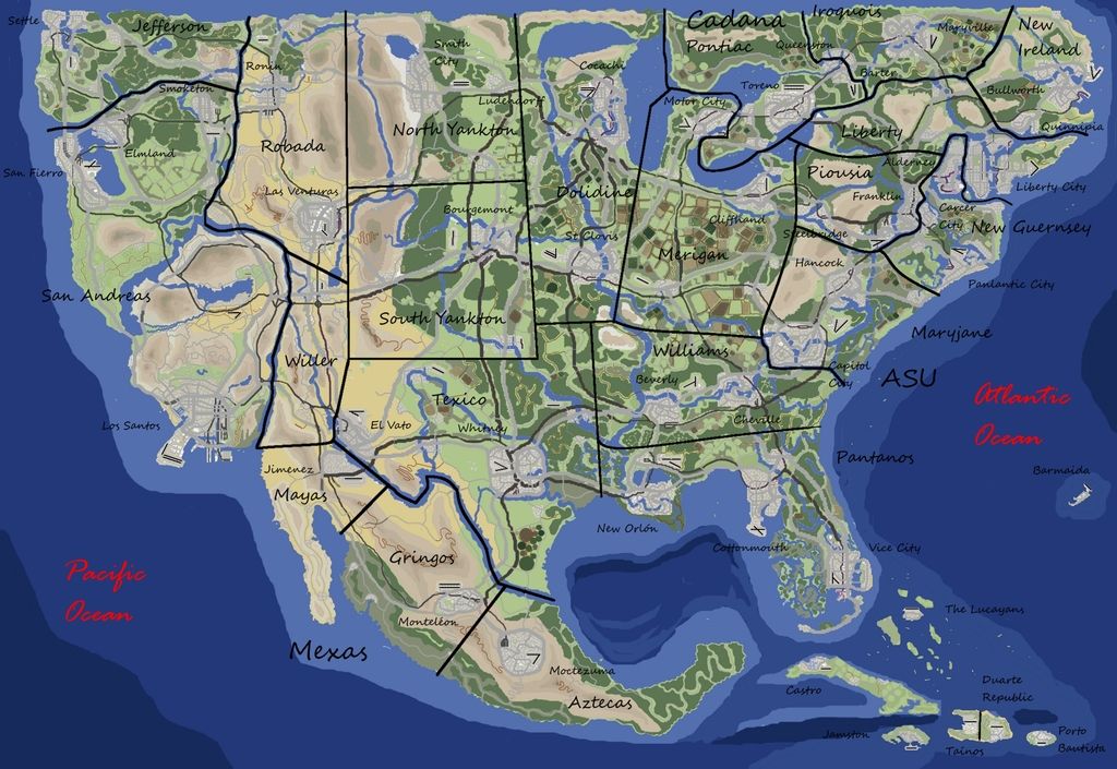
Here is the entire United States GTA'ed.
http://i1368.photobucket.com/albums/ag179/gtafan555/gta_america_map3_zpsssl6usgk.jpg
I like how the Dakotas are renamed North and South Yankton and New Jersey becomes New Guernsey.

You can find these, and many more maps, including Europe, Asia and Africa on the GTA Mapmaking Forum.
http://s1368.photobucket.com/user/gtafan555/media/gta_africa_1.9_zpssmpsuimj.jpg.html

NOTE: This is not an endorsement of a violent, sexist video game that may encourage crime and DUI (I don't know, I've never played.)  I'm only here for the maps.

Wednesday, April 13, 2016

1915 LA Auto Trip Map

This map was produced by the Automobile Club of Southern California in 1915. It shows a 60-mile round trip from Los Angeles to Topanga Canyon.
https://upload.wikimedia.org/wikipedia/commons/5/5f/Automobile_road_map_from_Los_Angeles_to_Topanga_Canon_and_return%2C_1915_%28AAA-SM-004587%29.jpg
Click to see it in higher resolution. Here is a detailed view if you don't feel like waiting for the image to load.
There are lots of nice details, including hatch marks for the hills, generalized grids in the built up areas, and grade percentages listed in the canyon. The mileages are marked in circles going counterclockwise from downtown LA. Seems odd that they would send you in that direction (all left turns) but maybe left turns were not a big deal in 1915. Reverse-direction mileages are also listed.

The map gives a good indication of what areas were settled in 1915. In addition to the obvious missing freeways there are also numerous boulevards that had not yet been built like Sunset Boulevard, west of Hollywood. Nevada Avenue shown in Santa Monica is now an extension of Wilshire Boulevard.

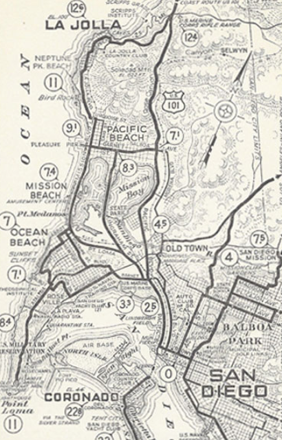
If you like this map, there's a treasure trove of Automobile Club of Southern California maps available from the USC Digital Library. Most of these are trips from or around Los Angeles. Some good auto club maps of San Diego can be found on John Fry's page - for example this one.
https://www.johnfry.com/pages/PhotoSanDiego024.html

Wednesday, July 22, 2015

Soviet Military Maps

A recent article in Wired details how some western map enthusiasts got a hold of thousands of military maps from the disintegrating Soviet Union. These maps are very detailed and accurate, often showing features not seen on government maps such as those from the USGS or Britain's Ordinance Survey. They are also beautiful and somewhat creepy.
Golden Gate Park, San Francisco
There are obvious military uses such as describing the materials and carrying capacity of bridges, military installations, and the spacing of trees in forests...
The Pentagon
San Diego naval facilities compared with the less detailed USGS map (right)
...but they also show factories, piers, bus stops and residential subdivisions. The article extensively interviews John Davies who is working on a book about Soviet military mapping. He suspects that they are more for the purposes of occupation than for an actual invasion. There may have also been an interest in  studying the economic systems of the countries through urban layouts. Davies has an impressive website, full of examples of these maps. Below are some images from his pages.
http://images.jomidav.com/worldmapsh35_003.jpg
Maps come in various scales from worldwide at 1:2,500,000, to very detailed 1:10,000-scale city plans. I prefer to focus on the larger-scale maps for their level of detail.
Manchester, UK


This is a detail of the Boston map showing the Diamond Middle School in Lexington, Massachusetts. I wonder if Davies included this to add some drama. They mapped the whole area but focusing a school lends a creepy "they're coming for my kids!" aspect to it.
http://images.jomidav.com/SovietMaps/B3.pdf
I often ride my bicycle through this school-next time I'll look out for spy planes!