Showing posts with label poland. Show all posts

Wednesday, January 7, 2026

Overlooked Mapping Highlights from 2025-Part 2

Here are some more mapping highlights from the last year:

 5. Silk World War II escape maps

This is from an episode of a podcast called What’s Your Map featuring former cartographic researcher in the UK Ministry of Defence Barbara Bond

Top secret British intelligence agency the MI9 produced a series of maps on silk (and later rayon) designed to help soldiers evade or escape from capture. This map is of Danzig (Gdansk), where the Vistula River enters the Baltic Sea.


Escapees used their knowledge of these areas to direct others to Swedish ships where they would be safe to escape to that neutral country. Maps were printed on fabrics such as silk, which could be stitched into clothing or kept in a pocket and did not make any noise when folding or unfolding them. The maps showed where coal is loaded onto Swedish ships, the arc of light to be avoided, ditches where people could hide and the network of railroad tracks that would need to be traversed. More on these maps and on Bond’s career can be heard on the podcast.

6.  Mapping the Wikipedia Rabbit Hole

WhereWiki allows the user to enter any Wikipedia page and see all of its hyperlinked connections in any given area. When I first saw this, the keyboard player for the Cure had just died so I chose the band’s page and the area around Crawley, UK* where they were formed.


A click on any point brings you to the referenced page. The green dots are locations and the blue are people or groups.


*You can choose the default area (where you are now) or just about any other place on earth and you will likely find plenty of geographic links to whatever page you chose. 

-via Maps Mania


7. Smell Map of the Minnesota State Fair

Jake Steinberg, a cartographer and journalist for the Minnesota Star Tribune created a map of the smells of the State Fair. You can see the full map and article here but you might hit their paywall


8. Inundation Map of the Town of Guadalupe (1819)

Guadalupe, now part of Mexico City suffered a major flood in 1819. The entire area was in the basin of former Lake Texcoco and floods were a frequent occurrence


-Maps via Pedro Zurita Zaragoza on that great mapping site known as LinkedIn.

The map shows inundated areas in aqua tones. Two waterfalls shown at the bottom are breaches of the Guadalupe River.


Text in the legend describes how canoes were needed in the plaza and a note at the bottom states that the floodwaters receded “by virtue of the wise measures of His Excellency (the viceroy), thus preventing its spread to the capital.” Plans to drain the area took almost a century after this to be implemented and this was largely responsible for drying the entire region.

9. 12 Foot Wool Map Needs a New Home

 A group of up to 18 women in County Wicklow began making a 12 x11 foot knitted and crocheted map of Ireland in 2019. 


As reported by The Journal (Ireland). Most of the project took place at Carnew Community Care, a centre for older people. Now that it is finished they are looking for a place where it can be publicly displayed. This was from July. I have not been able to find any follow up on whether they’ve found a location for it.


 -via The Map Room


Wednesday, May 4, 2022

My Family's Exodus from Ukraine

A few weeks ago some of my family members had a Passover seder. Passover is an exodus story. With huge numbers trying to leave Ukraine right now our thoughts turned to my own family's exodus from there. Rising antisemitism, employment restrictions and forced military service drove my family to risk everything to escape from Khotyn, Ukraine (then part of Austria-Hungary) and come to the United States. My great grandfather was the first to leave, in 1905. He traveled by steamship from Hamburg, Germany to Philadelphia. How he got to Hamburg is less clear but the shipping companies arranged for passengers to travel there by train with minimal harassment. I made a map of the trip based on railroad maps of that era, making assumptions about the most likely route across Europe.

There was no railroad in Khotyn at the time so they would have needed to travel the 30 kilometers to Czernowicz (not Cherivsti), probably in secret. My great grandmother followed with several children two years later. It must have been very frightening to leave everything behind to go to a place where they didn't know the language or how safe they would be. I'm sure today's Ukrainians are going through similar or worse horrors. Here is a second, less interesting map I made to complete the journey.

There is a story about my great grandmother going grocery shopping on her first day and not recognizing the house on the way back because the houses in South Philadelphia all looked the same. She had to walk up and down the street a few times before a neighbor came and helped her. If you see a lost refugee, They might need your help!


Wednesday, February 17, 2021

Polish Phonetic Map of Britain

This map was recently featured in an episode of Map Men covering Soviet cold war cartography. It shows southeastern British place names spelled phonetically to teach would be Polish invaders how to pronounce them.

The map was originally put on Twitter by former Economist researcher Alex White but the original tweet appears to be gone. The image above is via The Sun. Some fun names include Saufend-on-Sji (Southend-on-Sea), Hejstynz (Hastings) and Byszeps-Stofed (Bishops Stortford).

A bit shocking to think about perhaps but it makes for some nice wall art


This version was created by Maple Tea based on the original version.


Wednesday, August 28, 2019

The Battle for Germany, 1944

My wife found a treasure trove Life Magazines from the 1940's on the curb. The issue from 75 years ago today has some excellent maps showing the war situation.

In addition to this overall map are three maps showing greater details of the western, southern and eastern fronts.
A zoomed in view shows the slow movement of the line of Allied control in Normandy between June 6 and August 18th, 1944.
The Southern Front map shows the recent landings in southern France.
The simple and clearly readable topography is a nice touch. Here is the Eastern Front.
Here is a little detail with the August 18, 1944 battle line clearly shown.

Wednesday, May 3, 2017

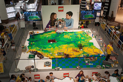
LEGO Poland

Last year, the first LEGO store in Poland opened, in a Warsaw shopping mall. The event was celebrated with a huge 3D model of the country built by kids and adults.
https://www.flickr.com/photos/biplex/28509278013/in/album-72157671813609731/
Here are some photos from various stages of completion via this Flickr gallery.
https://www.flickr.com/photos/biplex/29128034255/in/album-72157671813609731/


https://www.flickr.com/photos/biplex/29022656902/in/album-72157671813609731/

https://www.flickr.com/photos/biplex/29095453436/in/album-72157671813609731/
A couple more from the Hive Miner page
https://farm9.static.flickr.com/8334/29570331026_148842ac8c_b.jpg

https://farm9.static.flickr.com/8086/29314178810_e7cc164e1f_b.jpg

Wednesday, August 12, 2015

Warsaw Transit Animation

One of my readers, a student at UNIGIS Krakow sent me this video showing the growth of rail transit in Warsaw.
If you want to open it in a separate window here is the link.
Below are a couple of still frames, they show not only the growth of the rail lines, but also the expansion of the city's boundaries.

The white lines are street trams. Green is a commuter rail line and red is subway. Much of the expansion has happened in the last 10 years with the rapid development of the SKM urban rail - the orange lines.
 Here's a map of the SKM system.
https://en.wikipedia.org/wiki/Szybka_Kolej_Miejska_%28Warsaw%29#/media/File:SKM_Warszawa_-_wszystkie_linie.svg
The video was created using QGIS Time Manager software. The credits listed on the video are worth repeating here.
Basemap is cartometric and was created using open source GIS software - QGIS (http://qgis.org) and Time Manager for QGIS - plugin developed by Anita Graser (http://anitagraser.com).

During work on the film, authors based on datasets created by Magdalena Trzebiatowska, OpenStreetMap project, TRASBUS and TRAMWAR websites archive and GIS data shared by Geodesy and Cadastre Office of the Capital City of Warsaw.

This film is a result of „group project” realized during the UNIGIS Krakow study program (more at: http://krakow.unigis.net), and was made by UNIGIS students: Jakub Bobrowski, Joanna Gosztowtt, PaweÅ‚ HawryÅ‚o, Jacek Kuskowski and Kamil Onoszko under the supervision of a UNIGIS tutor - dr MaÅ‚gorzata Luc.
If you look any of this up on Google Maps today, you might find that the Vistula, the main river in Warsaw has dried up. I hope they get their water back soon.

Wednesday, May 7, 2014

Dug Tries Open Source Mapping

I was asked to make some maps showing a family's escape from Nazi-occupied eastern Europe during World War II. I've gotten used to relying on ESRI's expensive mapping software but nowadays there are many good open source tools available and many of them are platform neutral, meaning I can use them at home on my MacBook, or at work on my Windows PC or laptop. I hope to use more of these tools for personal and work projects.

I looked at some good tools for creating interactive (clickable or animated) maps, but this project only required a simple printed map. After some research I settled on the MapQuest API. This creates a map by entering a line of text in a web browser. For example this URL (the full text is below) creates a map showing the two towns in Belarus (variously under Polish, Russian and Lithuanian control at the time) where the grandparents came from.
http://open.mapquestapi.com/staticmap/v4/getmap?key=Kmjtd%7Cluu7n162n1%2C22%3Do5-h61wh&size=1200,1000&zoom=7&center=53.35,26.1&pois=yellow_1,53.219784,26.68405,0,0|red_2,53.489738,26.738491,0,0

The code above includes the image size, zoom level, center (in latitude, longitude) and two points ("pois" in the code) whose coordinates can be found by entering the name of a place or address in various online mapping services - Bing Maps is particularly easy to use to get these coordinates. The map above is oddly missing country names and needs the two points labeled. This is easy to do by saving the image and bringing it into Paintbrush, a free Mac program, or Paint if you're using Windows.
https://blogger.googleusercontent.com/img/b/R29vZ2xl/AVvXsEgXH_M_QoT9nY75Hrt8YzYJv8cKT9Ad8XOQIXQqkYvqC29SHYMMP2IfSukSLsT_9tmFTRE74GpmqyyRNyBl0UMCx3e0mVdqyzZtCyhovcZuBgUBUFYMQPR8F2ZwFy4zNDrR8vGCADudtco/s1600/Belarus5.jpg

The same process resulted in this map of five addresses in Warsaw.
The map looks fine but doesn't really tell a story. To illustrate the forced relocations and disappearing family members, I used Inkscape, an excellent free program but with a steep learning curve, to create arrows and some text effects. The bubble text was done using my Mac's native Preview app, though this can also be done in Powerpoint, Inkscape (with difficulty) and other software packages.
Click on the map above to see the entire picture or look at this detail to get the idea.
I look forward to making the rest of the maps showing the family's difficult journeys through France, Britain, Spain, Portugal, Mexico and finally to the United States. It's been a good learning experience both about the mapping tools and the horrible past that we're lucky to have escaped.