Showing posts with label missouri. Show all posts

Wednesday, April 17, 2019

The Map that Claimed the West

In 1816 mapmaker John Melish drew the first coast to coast map of the United States.
Map courtesy of the Map & Atlas Museum of La Jolla
By extending this map all the way to the Pacific, he implicitly laid claim to these lands for the United States. At the time there were competing claims in the west between the United States, Great Britain and Spain. In his own words "part of this territory unquestionably belongs to the United States." Map it and it is yours. The power of the map's claim was such that it was used in future treaty negotiations between the United States and the European powers.

I had a chance to look at and photograph this map up close at the Map & Atlas Museum of La Jolla.

Melish had the benefit of information from Lewis and Clark's recent expedition to fill in many details. Here rivers with fancy names like Philosophy (Willow Creek) and Philanthropy (Ruby River) make their way to the Jefferson and eventually Missouri Rivers.
Photo taken at the Map &Atlas Museum of La Jolla
Sometimes the details are a bit exaggerated.
Photo taken at the Map & Atlas Museum of La Jolla

Here are some very detailed annotations along the Illinois-Iowa (Missouri Territory at the time) section of the Mississippi River.
Photo taken at the Map & Atlas Museum of La Jolla
In addition to the map's historical significance there are various other cartographic curiosities such as the incorrectly angled Lake Michigan, missing Illinois completely and putting Michigan on a diet.
Chicago's there, just in the wrong state.
Here is another curiosity
A theorized link to San Francisco Bay via the Rio Buenaventura (Green River in Utah) - here is a zoomed out look.


The entire map can be browsed at World Digital Library

Tuesday, November 25, 2014

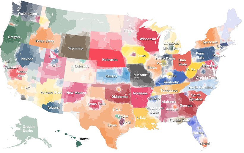
College Football Fan Map

The New York Times Upshot recently added College Football to its collection of fan maps.
http://www.nytimes.com/interactive/2014/10/03/upshot/ncaa-football-fan-map.html?action=click&contentCollection=The%20Upshot&module=RelatedCoverage&region=Marginalia&pgtype=article&abt=0002&abg=1&_r=0
I like how faithful the boundaries are to the state borders. Even in Kansas where they have a reciprocal arrangement with Missouri for in state tuition and plenty of students from Missouri, the boundary is pretty precise.

Using the university colors is a nice touch but it also has the effect of overemphasizing the red schools. What really jumps out here is Nebraska, Wisconsin and Ohio State, whereas Oregon's impressive reach into California, Montana and Alaska fades info the background. The other problem with the college colors is when you have similar adjacent colors. It's especially hard to distinguish Alabama and Georgia here. South Carolina and Auburn are also in the same color family.

I also like the small pockets of fandom for the lesser state schools such as Michigan State, Kansas State, Iowa State and that little university in Virginia whose relative lack of football success has made Virginia Tech the overwhelming choice of most of that state.   

The Upshot did a related map showing where college football is the most popular.
http://www.nytimes.com/2014/11/08/upshot/the-places-in-america-where-college-football-means-the-most.html

While I'm not convinced that the Facebook "like" is the most reliable measure of our culture, it does make for an easy data set and results in a clear pattern. If this map was done in a grey scale, reversed out and overlaid on top of the first map, you'd get a picture of not only who people like but how strongly. I'd do it if I had time but work beckons.


Wednesday, January 30, 2013

The Newberry Library Part 2

This post is a continuation from last week detailing my recent visit to Chicago's Newberry Library. In the map room was a book of maps of the Oregon Trail. Having gone to graduate school in Lawrence, Kansas near the beginning of the trail, it caught my attention.

The full title is "Topographical Map of the Road From Missouri to Oregon Commencing at the Mouth of the Kansas in the Missouri River and Ending at the at the Mouth of the Wallah Wallah in the Columbia." Produced in 1846 (when the Oregon Treaty settled a boundary dispute with the U.K.) by order of the U.S. Senate, this map is from the field notes and journal of Captain John C. Fremont, and sketches and notes from his assistant Charles Preuss. There are seven sections, above is the first, easternmost section.

I like that Westport, now the place to go in Kansas City to see bands and watch drunk 20 year olds get into fights, was its own little village. Actually, it was probably a much rougher and rowdier place back then. This detailed view came from the David Rumsey Map Collection where you can see the full maps with much better clarity.

The sections feature charts of meteorological observations for sunrise, noon and sunset for each day of Fremont's expedition.These include the temperature, altitude, wind direction and brief weather descriptions such as "perfectly clear" or "occasional thunder and light."

The locations of the expedition for each day are shown on the map, along with "cyphers" listing the distance from Westport. Each section has notes in the corner that provide some good atmosphere and local color. These are from section 1:
This section abounds with grass, water and fuel so that emigrants may encamp almost anywhere.
Elk and deer, the only game, are very scarce.
Selected notes from the other sections provide lessons in geography and attitudes towards non-whites.
Game - Antelope and Buffalo, the latter in innumerable bands.

Timber is extremely scarce, except on the islands*. Some driftwood and buffalo excrement makes the fuel as that of the camels does in the deserts of Arabia.

Good guard ought to be kept. Pawnees, if they do not kill, will at least take what they can from the travellers [sic] by force if they are strong enough, and by stealth if too weak to act openly.

With this section** the prairie ends, and the barren sage (artemisia) country begins.

East and West of this section [section 3] more or less buffalo and antelopes, but 50 miles from Fort Laramie each way no game is to be found. Grass - is scanty and only occures [sic] on the banks of the rivers and creeks.

At Sweetwater River*** buffalo appear for the last time and emigrants should provide themselves with well dryed meat.

West of the Green River the traveller [sic] is considered out of danger, as the Snake Indians are considered friends of the whites. Property however should be guarded.

This is the most trying section**** for the traveller on the whole route. Water, though good and plenty is difficult to reach, as the river is hemmed in by high and vertical rocks and many of the by-streams are without water in the dry season. Grass is only to be found at the marked camping places and barely sufficient to keep strong animals from starvation. Game there is none. The road is very rough by volcanic rocks detrimental to wagons and carts. In sage bushes consists the only Fuel. Lucky that by all these hardships the traveller is not harassed by the Indians, who are peacable [sic] and harmless.
Of course, these notes also provided highly valuable information for emigrants heading west.
 
*     the islands of the Platte River
**   section 2 covering the area between 98 and 102 degrees west longitude along the Platte River. 
***  near the continental divide
**** section 6-along the Snake River between Fort Hall (north of Pocatello)  and Fort Boise in Idaho.


Wednesday, August 29, 2012

A Mappy Day at the U-Haul Store

A couple of years ago I had a post about maps on U-Haul trucks. Today I had to go to the U-Haul store. While there I saw some more nice trucks.

This Missouri truck features the bats of Onondaga Cave State Park. From close up the bat at the top looks like its hanging right off the truck. I like the gratuitous highway details around St. Louis. The full graphic can be seen here.
The Alaska truck shows a large goshawk. The close up view reveals some nice relief detail of the Tongass National Forest.
Iowa's truck features the Manson Impact Crater. This crater is 24 miles in diameter and is believed to be caused by a meteor's impact 74 million years ago.
 Off goes the Missouri bat-mobile on a mission!
In the interest of full disclosure this was actually taken on a different day in a different location.