Showing posts with label iowa. Show all posts

Wednesday, October 27, 2021

More Cross Stitch Maps

 One of the talks I enjoyed at this month's North American Cartographic Information Society Conference was from Kara Prior, who uses maps to create cross stitch pattern designs - on sale on her Etsy shop.

She details the process in her talk - now available on YouTube. The idea is to take a map and make it as low resolution as possible while still conveying information. That way you see the individual squares. Here is a screen shot from the video illustrating this.

One of my favorites is the bedrock geology of Arizona. The colors really jump out - some of them look like they were taken from the state's flag.

 
She also has bathymetry and watersheds as well as several other, non-map patterns. The watersheds can be quite simple such as New Jersey,

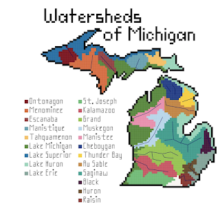
or much more complicated.

I'll end with some bathymetry examples


Wednesday, April 17, 2019

The Map that Claimed the West

In 1816 mapmaker John Melish drew the first coast to coast map of the United States.
Map courtesy of the Map & Atlas Museum of La Jolla
By extending this map all the way to the Pacific, he implicitly laid claim to these lands for the United States. At the time there were competing claims in the west between the United States, Great Britain and Spain. In his own words "part of this territory unquestionably belongs to the United States." Map it and it is yours. The power of the map's claim was such that it was used in future treaty negotiations between the United States and the European powers.

I had a chance to look at and photograph this map up close at the Map & Atlas Museum of La Jolla.

Melish had the benefit of information from Lewis and Clark's recent expedition to fill in many details. Here rivers with fancy names like Philosophy (Willow Creek) and Philanthropy (Ruby River) make their way to the Jefferson and eventually Missouri Rivers.
Photo taken at the Map &Atlas Museum of La Jolla
Sometimes the details are a bit exaggerated.
Photo taken at the Map & Atlas Museum of La Jolla

Here are some very detailed annotations along the Illinois-Iowa (Missouri Territory at the time) section of the Mississippi River.
Photo taken at the Map & Atlas Museum of La Jolla
In addition to the map's historical significance there are various other cartographic curiosities such as the incorrectly angled Lake Michigan, missing Illinois completely and putting Michigan on a diet.
Chicago's there, just in the wrong state.
Here is another curiosity
A theorized link to San Francisco Bay via the Rio Buenaventura (Green River in Utah) - here is a zoomed out look.


The entire map can be browsed at World Digital Library

Wednesday, January 14, 2015

Big Ten Games of Thrones Map

Like many Americans, I spent way too much time Monday night watching the NCAA Championship football game. While not paying total attention, this commercial for the Big Ten Conference really jumped out at me. The commercial is called "Maps" and is based on the Game of Thrones intro (with the same music.)
It constructs a flyover of the US, starting at the Rose Bowl. As you pass by iconic buildings, stadiums and landmarks pop up from the landscape. Here is a tour using screen grabs from YouTube.

From the west coast you fly across the mountains to Nebraska, the current westernmost outpost of the conference.

Next comes Iowa, then Minnesota, then Wisconsin.
One of the most dramatic moments is watching the Chicago skyline pop up in front of the Northwestern logo. Note the theater references for Northwestern and Iowa. The mist coming off the Ohio River adds to the medieval theme.
The Michigan-Ohio State rivalry is about as big as it gets.
From there, it makes the jump to the east coast to cover the conference's recent acquisitions. Here are Penn State and Maryland with east coast icons such as the Capitol building, Washington Monument, LOVE statue and the Liberty Bell.
The flyover heads over the Atlantic and turns back to the west to include Rutgers the "birthplace of college football" (according to the ad) along with the NYC skyline and the ferris wheel at Seaside Heights, New Jersey. I like the reflections off the water.  
The full video is at the top - enjoy!

Wednesday, December 18, 2013

Map Ties and Other Gifts

Personally I hate ties and wear them as infrequently as possible. However, these map ties are pretty cool. Who wouldn't want a tie with a vintage 1868 pictorial map of Iowa City?

http://www.zazzle.com/vintage_pictorial_map_of_iowa_city_1868_tie-151593703370207631
You can customize them too - meaning you can pan and zoom to show your favorite part of town. I don't actually have a favorite part of Iowa City - I just picked one.
There are lots of vintage and other unusual maps listed. I like the weather map one.
http://www.zazzle.com/weather_map_custom_ties-151182078250058710

Of course these ties would look great with a pair of cuff links.
http://www.uncommongoods.com/product/custom-map-cufflinks

South Portland, Maine if you were wondering.

Wednesday, August 29, 2012

A Mappy Day at the U-Haul Store

A couple of years ago I had a post about maps on U-Haul trucks. Today I had to go to the U-Haul store. While there I saw some more nice trucks.

This Missouri truck features the bats of Onondaga Cave State Park. From close up the bat at the top looks like its hanging right off the truck. I like the gratuitous highway details around St. Louis. The full graphic can be seen here.
The Alaska truck shows a large goshawk. The close up view reveals some nice relief detail of the Tongass National Forest.
Iowa's truck features the Manson Impact Crater. This crater is 24 miles in diameter and is believed to be caused by a meteor's impact 74 million years ago.
 Off goes the Missouri bat-mobile on a mission!
In the interest of full disclosure this was actually taken on a different day in a different location.

Thursday, July 12, 2007

MOTW #83


One of my pet peeves is when worthwhile, timely information gets put on the web and then is never updated. This example is cited as a "recent map" from a company that works with newspapers to put maps on their web pages. The map shows "Rummage Sales"* in the "Siouxland" for the weekend of April 14th - note that the date at the top is today. This is/was useful information and if they kept it up to date could be still.** If not take it off or the residents of Ascot/Broadmoor should be expecting visitors this weekend, sale or not.

*I'd like to see a map showing what regions of the country use what terms to describe yard/garage/tag/rummage sales

** I can think of several other ways they could improve this site but I've already gone on for too long here.