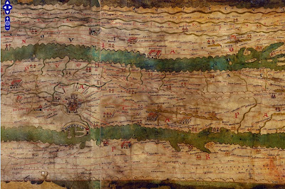
This weekend I was in New York City and had a chance to wander over to the Institute for the Study of the Ancient World (ISAW) to see their exhibit, Measuring and Mapping Space: Geographic Knowledge in Greco-Roman Antiquity. The exhibit features a 1:1 scale digital replica of the Peutinger Map, the only known surviving world map from the Roman Empire. This is a medieval era copy of a map from Roman times housed at the Austrian National Library in Vienna. The map is over 22 feet long and only about 13 inches wide. The digital replica takes up one wall of the gallery. Here are some photos from my phone.
The exhibit at ISAW only goes until January 5th, but hopefully the online resources will remain available.
The map is centered on Rome. Above are the roads radiating out of Rome, including the Appian Way. It is meant to show a schematic road network and the extent of the empire's control from the British Isles to India and Sri Lanka. The geography is highly distorted to fit the dimensions with the areas closer to Rome much larger and more accurate. Expanses of open water are reduced to narrow channels. Small cities are represented by twin towers while larger ones show temples and other complexes. The largest cities, Rome Constantinople and Antioch are shown with more elaborate symbols. Below is a section in Mesopotamia.
You can see these areas much more clearly on the ISAW map viewer. This allows you to pan and zoom around the entire map, except for the far western edge - missing from the original map. You can also add lines and text digitized from the original for clarity.
Wikipedia also has a cleaned up high resolution image of the map. The missing western areas were reconstructed by Konrad Miller in 1887-88 and show up with a white background. The original parts of the map are shaded in yellow. The preview image below gives you an idea of the map's crazy dimensions.
Wikipedia also has a cleaned up high resolution image of the map. The missing western areas were reconstructed by Konrad Miller in 1887-88 and show up with a white background. The original parts of the map are shaded in yellow. The preview image below gives you an idea of the map's crazy dimensions.
The exhibit at ISAW only goes until January 5th, but hopefully the online resources will remain available.


