Wednesday, April 29, 2015

Humanitarian Open Street Map

The Nepal Earthquake has caused tremendous destruction. The Humanitarian OpenStreetMap Team (HOT) has been responding to these kinds of emergencies for several years now. They are recruiting volunteer mappers to improve maps in the affected areas to help disaster response. There is a small learning curve and the instructions are a bit vague in places, but anyone with basic computer skills can help out, including me. Here is some work I did yesterday in a valley east of Chautara, about 25-30 miles from Kathmandu.
I added buildings and paths to the map based on low resolution aerial photos from Bing.
To get an idea of how spotty the mapping is in this area, here is a map of a nearby quadrant. There are lots of houses and other buildings but many of them have no known road access. The dashed lines are listed as foot paths. There is probably motor vehicle access along these paths and along other routes that are not apparent from the aerial photos but the only known "road" on this map is the red line in the bottom right corner.
While mapping is still very incomplete in the area, you can see how much detail has been added to OpenStreetMap, when compared to Google Maps (right side below.)
Comparing a more urban area gives you a better picture of the detail that has been added to OpenStreetMap - this is near Tinchuli, just northeast of Kathmandu.

The rural area above was specified as a priority when I logged in. When you begin, they present you with a map showing which areas need work and where the priorities are. The areas are divided into grids and you can pick one or let them assign you a grid to work on. The unshaded areas are the ones that need work. This image is for a second pass-the first pass was mapped a few days ago.

In fact, mapping of Nepal has been ongoing for a couple of years now. The HOT anticipated this kind of emergency two years ago and had a mapping party - complete with a nice cake!.
Here is a quote from the project page, February, 2013.


Recently, several reports have warned that this spectacular nation is at high risks from earthquakes. According to Nepal Risk Reduction Consortium Secretariat, a mega-earthquake—which could occur at any time—is estimated to kill more than 100,000 in the Kathmandu Valley alone, injuring another 300,000 and displacing up to 1 million.
If anyone in the Washington D.C. area is interested there is a three day mapping summit there starting tomorrow (April 30th.) Hopefully someone makes them a nice cake - they deserve it!

Wednesday, April 22, 2015

NBA Shot Maps

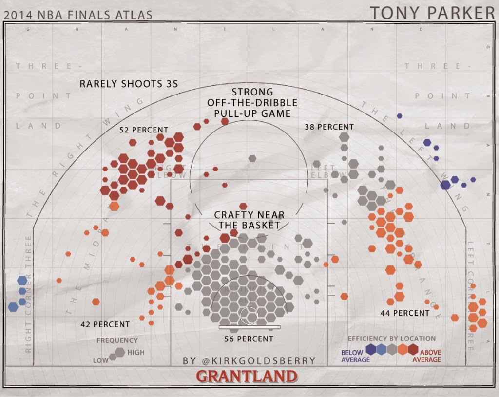
The NBA Playoffs are back. Geography professor Kirk Goldsberry has created a sub-genre of mapping-showing the spatial pattern of basketball players. These images from last year's NBA Finals appeared on Grantland's Map of the Stars. While the Miami Heat are not in the playoffs this year, LeBron James plays on with the Cleveland Cavaliers.
https://espngrantland.files.wordpress.com/2014/06/lebron1152.jpg
 Blue hexagons represent areas of below average shooting. Red areas show his sweet spots.

The San Antonio Spurs have had a remarkable run. The 2015 playoffs may be the last to feature this group intact. According to the chart below Tony Parker has few weak areas.
https://espngrantland.files.wordpress.com/2014/06/tonyparker1152.jpg

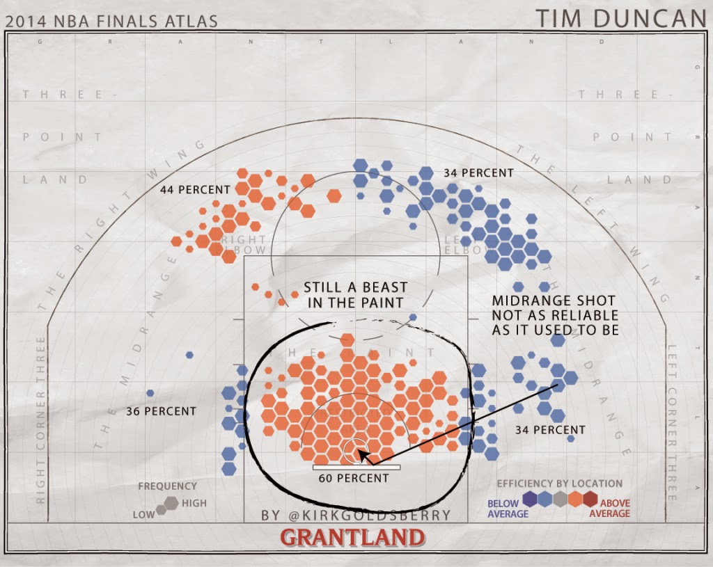
Tim Duncan is a more polarizing figure.
https://espngrantland.files.wordpress.com/2014/06/duncan1152.jpg
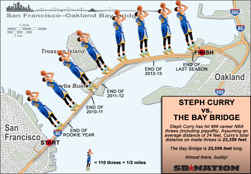
I have not been able to find a comprehensive collection of these charts but they seem to be out there for most of the NBA stars-just search for your favorite player plus "heat map."  For more NBA fun there's this map - from SBNation.
http://cdn3.vox-cdn.com/uploads/chorus_asset/file/679902/curry-map.0.png
 This map is at least six months old and I suspect he's made it off the bridge by now.

If, like me you prefer hockey, there's lots of this type of thing. Not as pretty but effective. I better hit the "Publish" quickly, button before Pekka Rinne's team gets eliminated.
http://i.imgur.com/t2dbjOL.jpg

Sports analytics has become a huge field in recent years. Geography is proving to be a useful in helping figure out how to defend against these players.

Wednesday, April 15, 2015

Detroit-Block by Block

National Geographic has a wonderful map showing population density by block. The dense areas have a vibrant color scheme, while the blocks with the highest level of abandonment are shown with the colors of the encroaching prairie.
http://www.nationalgeographic.com/taking-back-detroit/explore-detroit.html
The level of detail is impressive. However, the dull gray colors for non-residential and mixed use areas give a sense of deadness to some of the most vibrant areas of the city. The parks color also gets lost in all this detail. 
Below the map several highlighted neighborhoods (outlined in red above) are detailed with buildings outlines and photos.
There are also profiles and interviews of residents who are seeking to turn the city around. The article forgoes the larger business community (whose contributions have been detailed elsewhere) to focus on these residents.


Wednesday, April 8, 2015

Gotham City Mapped

Batman co-creator Bill Finger first named Gotham in 1940 for Batman #4. However, the city was not mapped until 1998, when a plot involving a catastrophic earthquake required a map. Artist and illustrator Elliot R. Brown was hired for the task.
http://www.eliotrbrown.com/0001.php
The city has always had a resemblance to New York but, according to Finger "We didn’t call it New York because we wanted anybody in any city to identify with it." With no formal training in cartography, Brown was tasked with creating a city that had all the necessary diverse elements.
"The DC Comics editors made it clear that Gotham City was an idealized version of Manhattan. Like most comic book constructs, it had to do a lot of things. It needed sophistication and a seamy side. A business district and fine residences. Entertainment, meat packing, garment district, docks and their dockside business. In short all of Manhattan and Brooklyn stuffed into a … well, a nice page layout." - Brown
Early sketches of his map can be seen on his website, including this one.
The city needed to be an island so that federal agents could seal it off from the mainland by dynamiting the bridges and tunnels. In addition to the New York elements, he also added some "Chicago-like" bridges in the middle of town, to "add some story potential."

Here is one version of the final product as it appeared in the comics circa 1999, via Smithsonian.
http://www.smithsonianmag.com/arts-culture/cartographer-gotham-city-180951594/?no-ist
So where is Gotham City? It is often considered to be on the east coast of the United States but it's an open question due to some contradictory descriptions of it's location. From io9's Is Gotham City Really in New Jersey?
Gotham also has been hit by earthquakes (1999's No Man's Land...), sits in the Central Time Zone (Man-Bat #3), and was a cowboy town in the 1800s (2011's All-Star Western).
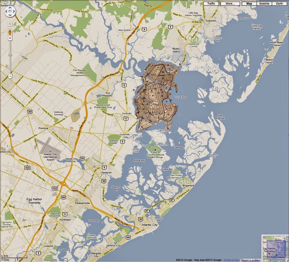
The Batman wikia has a modified google map placing Gotham in Great Bay, just north of Brigantine (and Atlantic City), New Jersey.
http://batman.wikia.com/wiki/Gotham_City
The io9 page shows this image from a 1978 comic also placing Gotham in South Jersey but on the Delaware Bay, across from Metropolis (Metropolis, Delaware?)
http://io9.com/5934987/is-gotham-city-really-in-new-jersey

That's a lot of action for an area mainly populated by horseshoe crabs.

Wednesday, April 1, 2015

Google Pac Man Cartography

The Google Maps Pac Man April Fool's map has been up for a while now and has been mentioned all over the web. They have transformed the world into a giant Pac-Man maze. I decided to take a look at some of the more interesting and/or well-known places on earth to play. Some of them look fantastic even if the street patterns are a bit vague at that close a zoom level. Enjoy!

I have always been really bad at Pac-Man. Here I am about to get eaten by Pac-Man bullies on the suburban Rochester, New York street where I spent much of my formative youth.
Getting mugged in Queens Park, Toronto, Canada.
The Battery, Manhattan, NYC
 Chased by Putin's thugs outside of Red Square, Moscow
Climbing up the mountain to get to Machu Picchu in Peru.
The Ginza area, Tokyo, Japan
Stupidly chasing my tormentors in Cabo San Lucas, Mexico
 Circling the Arc de Triomphe, Place de L'Etiole , Paris
Finally, getting a measure of revenge near the Royal Residence in Central Marrakesh, Morocco.