Wednesday, February 22, 2017

Tokyo on Foot

Florent Chavouet is a French graphic artist. He spent six months in Tokyo ("the most beautiful of ugly cities") where his girlfriend had an internship. He spent his days there riding a bicycle to various neighborhoods and sketching them. Eventually these became a graphic memoir, Tokyo on Foot. The book is full of great hand drawn maps. Here is part of the table of contents.
Here is a detail from the house they lived in in Ochiai.
The circled numbers show where sketches on those corresponding pages were drawn. Here are some details from the busy Shinjuku neighborhood.
Scattered comments such as "smells of Yakitori" really bring the place to life.
Gakushuin University
And finally a map of a bike trip to Kamakura and the Miura Peninsula to the south.
The non-map sketches are also wonderful. If you're fascinated by Japan this is a wonderful, unique book for armchair travel


Wednesday, February 15, 2017

The Shadows of New York City

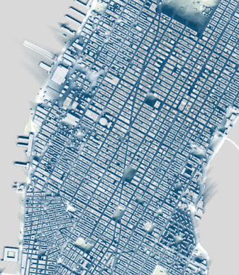
For Part 3 of my New York trilogy, I am revisiting a fantastic interactive map from the New York Times. It shows a day's worth of shadows on the two solstices (it was posted at the Winter Solstice) and at the vernal equinox. Here is midtown Manhattan on December 21st.
https://www.nytimes.com/interactive/2016/12/21/upshot/Mapping-the-Shadows-of-New-York-City.html?rref=collection%2Fsectioncollection%2Fupshot&action=click&contentCollection=upshot&region=rank&module=package&version=highlights&contentPlacement=1&pgtype=sectionfront&_r=1
The dark skyscraper canyons are striking. A closer up view shows why building heights cause such political upheavals. Below we see the shadows cast over the south side of Madison Square by the buildings along 23rd St.
 If you hover over a building you get the height and year built. The Madison Green Condos cast a long and persistent shadow over a corner of the park.


The map was created using publicly available 3D models of New York's buildings The diagram below gives a good idea of how the shadows for each area are calculated.
The interactive map is at the top of the article. You can go to an area of interest and choose your season. Here is my grandmother's old building in the Bronx in winter, spring and then summer.


Since people love to look at stadiums on these things here is Yankee Stadium. In winter it does not get much sun but in summer there's plenty of sunshine for baseball. Too bad most games area at night.


Wednesday, February 8, 2017

The Origins of Hip Hop

Last week I highlighted a map from the colon-heavy You Are Here: NYC : Mapping the Soul of the City. Another good map (by RJ Beals) shows the origins of Hip Hop. Due to copyright restrictions I do not have the final map but an early version is on photobucket via OldSchoolHipHop.
The lower right corner of the updated version contains a short history of how DJ Kool Herc threw a party at the 1520 Sedgwick Avenue recreation center (Herc's family's apartment was also in this building) and introduced a new DJ style. This involved playing the same part of a song from two identical records on two turntables to extend the instrumental breaks. Here is a detail showing the rec center and other Bronx locales.
Herc, though considered the father of Hip Hop is an often overlooked character in this history. The Twilight Zone was his first professional DJ job. He also had jobs at the Sparkle Club, PAL and Hevalo. Burger King is on the map because they used to unscrew the tables from the floors and have DJ parties there.

The map is cleverly designed to look like the soles of a sneaker - the final version has "Sneakers Uptown Shoes Down!" added as a subtitle. 

For more info see the message board page at OldSchoolHipHop or buy the You Are Here book

Wednesday, February 1, 2017

The Meltropolis

There have been many excellent map books lately that I have not had a chance to properly look at. One recent addition is a new Katharine Harmon "You Are Here" volume NYC : Mapping the Soul of the City. One of the best maps is by illustrator Rick Meyerowitz (also see his New Yorkistan map) - "The Meltropolis 2108" - image via Atlas Obscura
http://assets.atlasobscura.com/media/W1siZiIsInVwbG9hZHMvYXNzZXRzLzA4NDc4MWYzMzc1ZTc4MDE3OF9TY3JlZW4gc2hvdCAyMDE2LTExLTIyIGF0IDkuMDMuNDggQU0ucG5nIl0sWyJwIiwiY29udmVydCIsIi1xdWFsaXR5IDkxIC1hdXRvLW9yaWVudCJdLFsicCIsInRodW1iIiwiMTI4MHg-Il1d/Screen%20shot%202016-11-22%20at%209.03.48%20AM.png
The map shows New York as not just the victim of global warming, but also of mass consumerism. The map is full of watery puns such as Central Puddle, the Met Aquarium (the flooded museum), Lagoona Airport, ChelSEA, Brooklyn's Atlantic Avenue changed to Atlantic Ocean Avenue and the former site of New Jersey. Wall Street has become the Outer Banks separated from the rest of the island by the Financial Straits.

Sociopolitical humor is found in place names such as the Snipesland Tax Free Zone, the Condo District, Times Square renamed Murdoch Square, Staten Island re-branded as Mega Store Island and Ivankaville. Other nice touches include the a large spud known as the Freedom Tuber and the Monument to the Last Liberal.

To see more details click the map above, see the Atlas Obscura article or buy the book.