Wednesday, September 27, 2017

Prisons of New Jersey

In 1955 the American Prison Association held its conference in Atlantic City. A map of New Jersey's highlights titled New Jersey Invites You to Come and See it All was created to welcome guests.
http://mapmaker.rutgers.edu/NJinvitesYou_1955.gif
These highlights were mostly prisons in their eyes. For example, the nearby Prison Farm at Leesburg.
Sure, there are other things to see in New Jersey like some statue of liberty but check out the Rahway Reformatory.
Washington crossed the Delaware, there's a world-class university but the Trenton Home for Girls is really something!
High Point is one of the few places highlighted that sounds like a nice place for the spouse to visit while you're at the conference.   
Even the roads look imprisoning with the light posts evoking watch towers or fences.
Nothing much to see in this area-except for the Camden County Workhouse.
You can browse the entire map on the Rutgers Mapmaker web site.

Wednesday, September 20, 2017

Time Maps

Mapbox has created this fantastic "map" - really a diagram showing web search results from the perspective of time, in this case walking time. The map is a concentric circle diagram with geography only preserved in the direction of each result.
In their own words Mapbox has "swept the physical world away completely, in favor of the time needed to move around it." The results are from Foursquare and are somewhat dubious as I will discuss.

I chose Rittenhouse Square in Philadelphia, a favorite spot since childhood. One nice feature was I just put in the name of the square, no city, state or any other info and it knew exactly where to go. I searched for ice cream, often problematic in that neighborhood because places seem to come and go quickly. Click on any spot and you get a walking route with directions.
You can click "Find me" to get your location or start searching an address. The address search is overly eager. I started to enter an address where I'll be going soon in upstate New York and it took me first to Birmingham, UK and then to Toronto before I could finish typing.
Of course, a map like this is only as good as the information behind it. When I did some searches of my neighborhood, I found quite a few businesses that closed several years ago while some places that are well over five years old did not appear.

For some details on how and why see the this Mapbox blog post.

Wednesday, September 13, 2017

Hurricane Footage from Snap Map

I don't spend much time with social media. As a result, I've been missing one of the bigger map stories of the year, the growth of Snapchat's Snap Map. Hurricanes Harvey and Irma have brought Snapchat to the forefront of media coverage. 
Image via Elite Daily
According to Elite Daily, when Irma made landfall Snapchat received 250,000 submissions within 24 hours. These numbers are way higher than the already high 100,000 daily submissions from Hurricane Harvey. Major media outlets used these pictures and videos in their coverage. The map part of the app is useful to focus on what is happening in specific geographic areas.
Image via Recode
The yellow-red colors in the background show where larger concentrations of posts are geotagged. Zoom in to see more Snapchat pictures and videos. Here's an example via Recode.
Early previews of the mapping function focused on it as a fun way to send your private data to corporations.
http://www.refinery29.com/2017/06/160114/how-to-use-snapchat-snap-map-update#slide-6
Having fun at the club!!!
It's somewhat ironic then that it has become a way to voyeuristically watch people's lives get torn apart by natural disasters.

NOTE: I tried to get Snapchat on my old phone so I could see for myself and get my own images for this post. Unfortunately I do not have enough storage on my phone to download the app. Sorry that I have to rely on second hand images like the ones above instead of providing original content.

Thursday, September 7, 2017

Disaster Mapping Help

While Hurricane Irma does some scary stuff and Houston is still bailing out, here is a reminder that anyone can help disaster responders from their desktops through Humanitarian Open Street Map. By identifying roads and buildings from aerial photography, you can help organizations like Doctors Without Borders and the Red Cross find affected people and buildings. No prior mapping knowledge is needed.
In a previous blog post, I talked about my experience helping with the 2015 earthquake in Nepal.
 
There is not yet a mapping project for this year's hurricanes but there probably will be as places recover.

UPDATE:         Now there is!

You can also help with their Malaria Elimination Campaign.  Here is a screen shot of buildings mapped in Zimbabwe so far.

Wednesday, September 6, 2017

Yum Yum Maps

Yum Yum is a travel magazine from the island of Hokkaido in Japan. They make their own hand drawn maps. My favorite one is Make Your Bento in Kyoto, showing where to buy the needed ingredients for a Bento Box and then where to enjoy your lunch.
http://www.tyy.co.jp/?p=2703
The map includes pairing advice and a checklist at the bottom of the page. Here are some details.
Another map hangs in a child's rest corner of a shop in a mall in Shihoro on Hokkaido. It shows places of interest in the town.
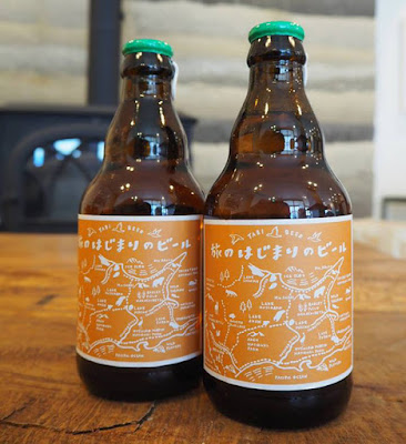
In nearby Obihiro, at the Hotel Nupka, you can enjoy one of these beers...
http://www.tyy.co.jp/?p=6198
 ... on top of this coaster.
http://www.tyy.co.jp/wp-content/uploads/2016/02/6004.jpg
Both maps are of the surrounding parts of Hokkaido. The beer is a "caution beer"whatever that means. From an attempted Japanese translation:
A caution beer from Tokachi "beer at the beginning of travel"...Tokachi is a label that maps the east Hokkaido area, which is rich in nature, to Shiretoko Peninsula and Nemuro. Brewed using 100% of barley from Dido / Naka-Tsuzu-machi.
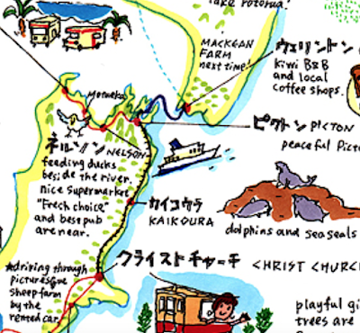
There are several maps of New Zealand also including this 60-day camper van travel itinerary.
http://www.tyy.co.jp/?p=2632
and this maybe too-cute tourist map full of personal observations.
http://www.tyy.co.jp/?p=2632