I was not aware ofKaren Wynn Fonstaduntil a recentarticlefrom the New York Times “Overlooked” series. Overlooked are obituaries about people whose deaths (in this case in 2005) were unreported in the Times. Fonstad created theAtlas of Middle Earthto accompany the works of J.R.R. Tolkien.
She had become enchanted with Tolkien’s works. Having studied cartography and completed a Master’s degree in Geography, she pitched the idea of creating an atlas to Tolkien’s American publisher. While Tolkien and his son drew the original maps* Fonstad’s atlas represents a complete picture of Middle Earth during all of its ages and across all of Tolkien’s books. It discusses the geology behind land formations and includes city maps and floor plans or important buildings. Here is a detail of Frodo and Sam’s route to Mount Doom.
Her work was well received by Tolkien fans and scholars alike. To illustrate her impressive landscape details, here is the southern section of the Misty Mountains. They have a nice Swiss Topolook.
Alaska’s famous Iditarod dog sled race concluded last week. Global warming meant the route needed to be moved further north to start at Fairbanks instead of Anchorage.
While not the first time the route has run from Fairbanks, this year’s race was not planned to go along the northern route. The route was abruptly changed due to “low snow” conditions and reports that a challenging section of the trail was “completely bare, down to the dirt and rocks.”
While there was still the ceremonial start in Anchorage, even that had to be shortened from 11 miles to a quick one and a half mile jaunt because there’s no snow on the ground. The snow along the truncated route was brought in from elsewhere and dumped along the course.
Jaune Quick-to-See Smith, a Native American artist died a few weeks ago. Her artwork highlighted a Native worldview juxtaposed with American pop culture and included many maps.
You can see much more of her work on herweb site. I will end withAdios Map(2021), showing different ways to say goodbye - to lives lost in pandemic, land destroyed by climate change among other goodbyes.
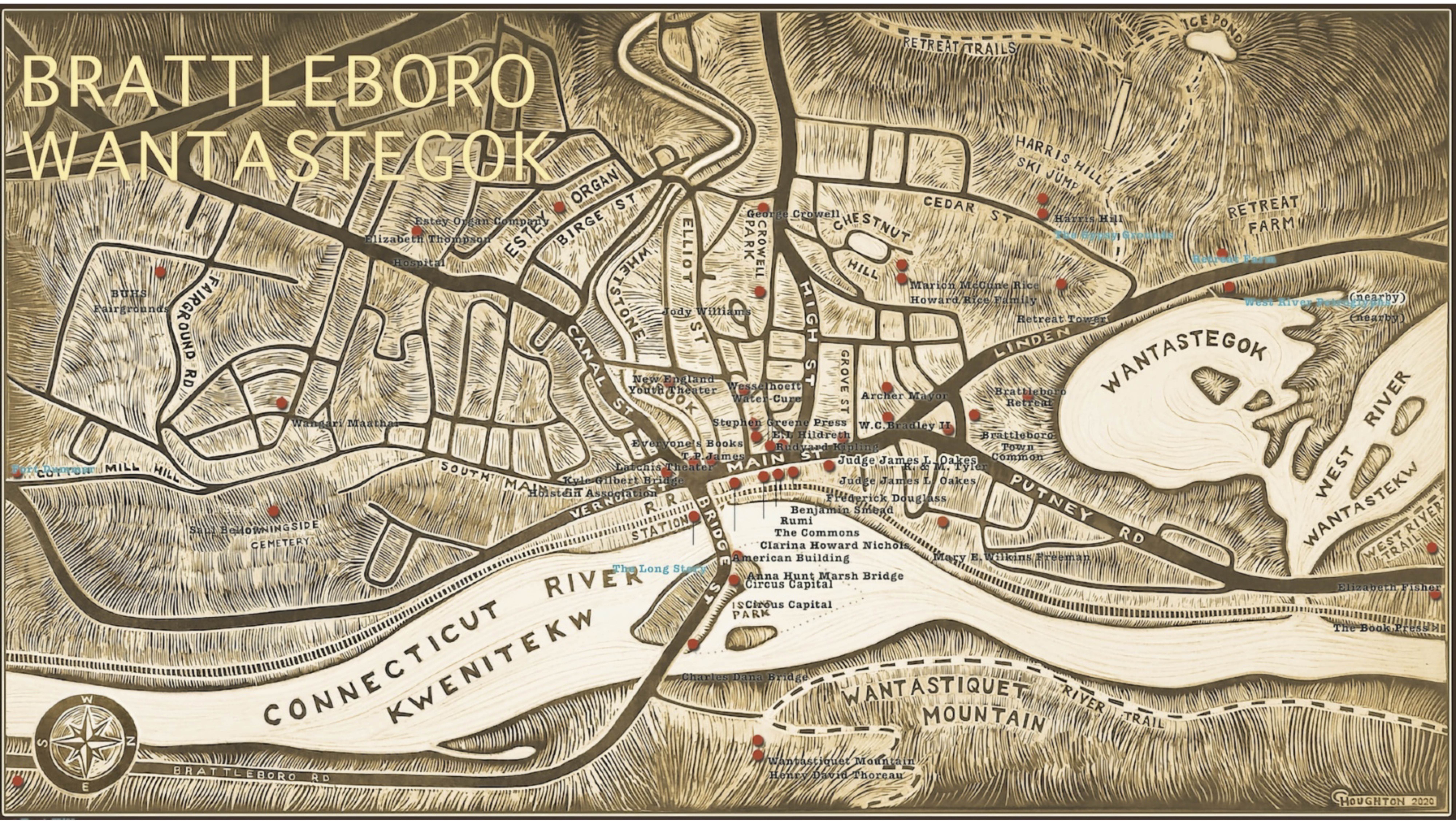
Last year I was in Brattleboro, Vermont and saw an interesting map on display. It is part of theBrattleboro Words Project. The project “connects community members to the Brattleboro area’s unique history, the art of audio storytelling - and each other” through audio pieces, maps and a GPS app that leads listeners on an audio journey of local people and places.
There are two maps; a city (above) and regional map. They can be downloadedhere. Indigenous Abenaki names are given equal weight on the map. Examples include the town name, Wantastegok and the river Kwenitekw. Here is a picture zoomed into downtown to appreciate the handmade details.
The regional map features portraits featuring notable people with local ties such as Rudyard Kipling, Saul Bellow andDaisy Turner.
Here is the Brattleboro area.
The process of creating these murals and maps is very interesting. It started with 10 clay landscape mural tiles, about 12 lbs each, 16"x16". They were hand carved by Natalie Blake Studios lead designer Cynthia Parker-Houghton. She was nice enough to share some details of the creation process:
“I took the information for the rivers off a Google Map, which I then re-oriented and then distorted distorted to give a birds eye view. So it was as if seen from the top of Mount Wantasticuit on the NewHampshire side of the Connecticut River gazing out West over Brattleboro and the surrounding region.
"I had this map printed out large at a print shop and then used it as a template to lay out the clay forms to represent the topography of the mountains. After this I draped square slabs of clay over the forms. These slabs then dried for a few days and then could be lifted to remove the clay mountain forms and also the paper templates. I believe I had a second set of paper templates printed which were slightly smaller to adjust for the clay shrinkage. I used this second paper template to mark out the rivers. I did this by drawing over the river lines with a pen which pressed through the paper to leave marks on the clay.
"Once the marks were made I removed the paper template and carved the details of the map. I carved away the iron oxide slip that had been painted over the entire surface. Wherever I carved it revealed the white clay. After we bisque fired the tiles, we used an industrial sprayer to apply the transparent glaze colors over the black and white image. We then fired it for a second time to a high temperature.”
The map was created from photographs of the mural with text added digitally.
Here is a video if you want to dig more into the details of the creation process.
Brattleboro Words is a project of the National Endowment for the Humanities. They will be revamping the map for 2026 when the whole Trail will be featured on the new Amtrak station outside track facing side of building.