There's also a big suspension bridge linking the Rocky Mountains with the Pacific Ocean and a 150 mile tall palm tree growing in central Florida. We also moved Mount Fuji to Mongolia for your convenience!


 This map in today's Boston Globe reminded me of Middle East expert John McCain's various gaffes (Iran, Iraq, Sunni, Shiite, who can tell the difference?) Here's a map of his "Iraq-Pakistan Border" courtesy of Matthew Yglesias and the Atlantic Monthly.

 This entry is entitled "The world is colorful and beauty" and was done by Ferina Tjahyana from the Pelita Harapan Junior High School in Tangerang, Indonesia. She was 13 at the time this map was done (2003).

 For a nice, detailed general reference map of the region click here.
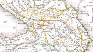 This is an interesting historical map of the region produced by American cartographer Thomas Bradford in 1835. Clicking the image will bring up a window so you can zoom and pan to get more detail.
 You can mouse over the dots to get basic information and a click on them will get pictures, diagrams, architectural drawings, links to schedules, game rules and much more. What's lacking is a mileage scale so it's not clear how close these places are to each other. Also some transit and/or parking/driving tips would be helpful. You can find that information in the "Spectator Guide"s but they could have put it in a more obvious place.
