Tuesday, November 23, 2010

Comic of the Week-Zippy Tackles Maps!

Sunday's Zippy features Bill Griffith's absurdist take on maps. The first frame features a nice wall map of Griffith's native Long Island. Click for a readable version.

Friday, November 19, 2010

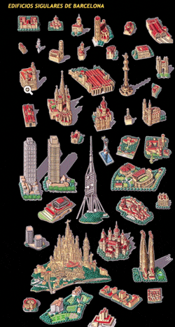
The World of Juan Nunez Guirado

Juan Nunez Guirado is an illustrator based in Spain who sent me a link to his work. Here is his world view.


He's done some nice pictorial maps and illustrations of various places in Spain. Here are some from Barcelona.


For a more detailed view, some soothing music and many more maps visit his website.

Wednesday, November 17, 2010

Mapping Gothic France

My brother discovered the Mapping Gothic France website at a lecture. The site is dense with interactivity. The main interface allows you to overlay various historic maps with your choice of current base maps, click on churches and buildings and connect to more information than you can possibly absorb in one viewing.


Like a chef you can mix and match your ingredients as you see fit-below you can see King Philip II invading Normandy over a tasty layer of road map.


There are timelines, links to authors, stories and essays and lots of information about churches. Each church has its own page with images 360 degree panoramas and stereoscopic views (though I could not get those to load) that require 3D glasses. For dessert, some screen shots from a panel that allows you to select churches and compare images and floor plans.


Friday, November 12, 2010

Map of the Weekend-Cape Shot

It's the weekend. Time to find your favorite map shot glass and drink a toast!

Wednesday, November 10, 2010

Nicaraguan "Invasion" caused by Google Maps - or maybe not.

Nicaragua invaded Costa Rica because of an error on Google Maps! At least that's the story being tossed around the internet in articles like this one and in Wired. Of course like many stories, the truth appears to be more complicated and less satirical. Ogle Earth has an excellent summary of the border dispute. Here are some basics:
  • The eastern part of the border between Nicaragua and Costa Rica is the San Juan River. 
  • The south bank (and sometimes east) of the river belongs to Costa Rica. The river belongs to Nicaragua but Costa Rica is allowed to use it for commerce.
  • Google maps incorrectly shows the border deviating from the river course giving a part of the Isla Calero to Nicaragua. Bing is basically correct although the alignment between the border and the river is poor.
  • In late October, Nicaraguan troops occupied a part of this land and began clearing the forest and dredging the river channel.
  • Costa Rica no longer has an official military to defend their land.
  • The official map that each country provided to the International Court of Justice both show the same border-along the river's main channel.
  • After the fact, the Nicaraguan government discovered the google error and used it to justify the troop incursion- from this article(translated.)
  • Nicaragua also uses historical changes in the course of the river channel to justify their claims

Here is a map of the area claimed by Nicaragua from Managua's La Prensa. The red line is claimed to have been the course of the river in 1897 when US President Grover Cleveland arbitrated a more detailed boundary (than the 1888 settlement) for this area.

However, the UN Settlement includes this map and contradicts Nicaragua's claim. The settlement clearly states that the boundary follows the main branch of the river and not the Taura Branch as claimed by Nicaragua.


Still, if you want to blame google maps go ahead - join the crowd!
************************************************************
UPDATE: Brandon T. sent me this video from newsy about the border dispute. Thanks!

Multisource political news, world news, and entertainment news analysis by Newsy.com

Wednesday, November 3, 2010

What I do for a Living-Part 1

Things are really busy for me this week. We have a big infrastructure evaluation project that I need to map and analyze every which way. Since I don't really have the time for an interesting, well researched post, here are some storm drainage pipes somewhere in Massachusetts. This is what I do in my non-spare time.


Wednesday, October 27, 2010

Mapping Municipal Inequity

The Cedar Grove Institute for Sustainable Communities uses GIS map overlays to demonstrate patterns of municipal discrimination against minority and low income residents. They began working in North Carolina with neighborhoods that were either targeted with undesirable projects such as highway bypasses or were ignored when building water or sewer services.

The map below is from Moore County in south central North Carolina. The brown area is Jackson Hamlet, a predominantly African American community. The red lines show the boundaries of the affluent golfing and retirement communities of Aberdeen, Pinehurst and Southern Pines. The dark lines are sewer mains.


Jackson Hamlet is surrounded but excluded from these areas meaning that they do not have sewer or garbage service from any of those towns and must rely on the county sheriff for police protection, rather than on the closer municipal police stations.

While the three towns have annexed land in other directions, they have all avoided Jackson Hamlet and demographically similar communities. The residents of these places have relied on septic systems, private trash haulers and/or burning garbage while in some cases watching the garbage trucks cut through their streets to get to the neighboring, more affluent towns.

In recent years the Institute has expanded its work nationwide. They helped residents outside of Zanesville, Ohio win almost $11 million in damages for years of unsuccessful requests for municipal water service. While the city expanded water service to newer, further away developments, African American residents in the Coal Run neighborhood were required to haul water from the water plant or pump it from contaminated wells.

This map shows how water lines were built to specifically serve the white residents of the neighborhood and played a vital role in the settlement.


The images above and some of the material came from an excellent article in Miller-McCune.