Tuesday, July 27, 2021

The Mysterious "P"

Help Montgomery County, Maryland solve a mystery. They are trying to figure out what the "P." abbreviations stand for on a Martenet & Bond 1865 map of the county.

The map was produced by S.J. Martenet & Co. in Baltimore. The "P" appears next to the names of property owners. It could mean "principal", "plantation", "place", or something completely different.  The company does not know because their records were lost in the Great Baltimore Fire of 1904. Here is another example image with the "P"'s after some of the Dr. Washington Duvall lands.

If you have any ideas you can help county historians by putting them on this Google Doc.


This post was largely stolen from the Montgomery County Planning Blog.

Wednesday, July 21, 2021

Big Game Fish

This pictorial map shows 56 kinds of fish. Click below for a zoomable map via the David Rumsey Map Colletcion.

Most states have their own fish, so big that its caught from across the state.
Most fishermen (no women here) are in boats but in Texas, of course, he is on a horse instead. Some other nice details include the Gulf Stream,

lists of fishing spots and records,

and inset maps of offshore fishing spots such as Tahiti, Hawaii and oddly New Zealand.

Diagrams of fish adorn the four edges of the map.

One other nice feature courtesy of the Rumsey collection is that you can look at it in the "geoferencer" and see how it overlays onto a modern web map.


Wednesday, July 7, 2021

The Banana Pancake Trail

An updated and maybe sanitized version of the Hippie Trail*, the Banana Pancake Trail is a non-specific route through southeast Asia for westerners.

The trail is named for the pancakes served by street vendors throughout the area. Restaurants, internet cafes, guest houses and other businesses have sprung up in these areas, most with English speaking employees to cater to western travelers. Sticking to these places will likely not give you a completely authentic picture of the region but it will be close enough for those who want to stay within a certain comfort zone.


*The Hippie Trail was a beat generation route through central Asia to India. For more info see Strange Maps or see an itinerary on the Afternoon Map.

via StrangeMaps


Wednesday, June 30, 2021

Lego World Map-Spreadsheet Version

The Lego World Map contains 11,695 Lego pieces. The land areas are meant to be colored in white,

but for the oceans they encourage creativity.  

The map is a grid and therefore lends itself to being replicated in Excel as Jon Schwabish of PolicyViz has done. He assigned a color for each grid cell based on the LEGO palette. In this article he describes the process and lets makes his Excel file available for download. Here is a close up.


So you can take this color by numbers approach to make your own creative spin on the world. My artistic skills are limited but here was a quick pass at it.

You can download your own spreadsheet here.


Wednesday, June 23, 2021

The Southern Underground Railroad

Mexico outlawed slavery in 1829. Texas fought for independence from Mexico in part to be able to reestablish slavery there. For those seeking freedom from Texas and other nearby states Mexico was a much closer destination than Canada. It was a much tougher trip than for those who went north without the support and protection available in free states. Most who tried to escape to Mexico likely never made it. Still Stephen F. Austin State University's Texas Runaway Slave Project has documented over 2,500 escapees.

Illustration by Erwin Sherman via Texas Highways 

Runaways may have been helped by Mexican immigrants, German settlers who were opposed to slavery and by their own skills at horseback riding. Crossing the Nueces Strip, the hot, arid land between the Nueces River and Rio Grande was particularly difficult but with a horse and a gun, it was possible. 

Once in Mexico there was still much adversity with few job opportunities, a language barrier and little local support. Still it was better than being enslaved. 

Without a major support network there are not established routes to map, just general flow patterns as seen on the map above. This map that commonly appears on the web shows a general flow southward through Texas in addition to the more commonly known routes.

via Pinterest

 More info at Texas Highways

Thursday, June 17, 2021

Vaccine Deserts

 A new vaccine equity planning tool has been launched by Ariadne Labs. It shows vaccine deserts, defined as areas with limited access to vaccinations. You can pick a state or zip code and see where these are. Here is Ohio.

There is a pretty clear pattern of rural areas having the least access. In contrast, earlier in 2021, there were rural and urban deserts as detailed by a Deloitte study quoted in the Missouri Independent. Here is a map showing (in blue) the deserts of Missouri,

Images via the Kansas City Star

and a close up of Kansas City.

The Ariadne tool is designed so that planners can advance their outreach to the areas most in need. From their web page.

“Vaccines are now increasingly available across the U.S., yet there is still a population struggling with access. Not everyone has the ability or time to spend an hour out of their workday or more to get their vaccine. By accounting for different modes of transportation — including public transit and walking — we hope public health officials and providers will gain a deeper understanding of how to reach all communities,” said Katherine Chou, Director, Product Management, Google Health.

Some of these deserts are in empty, disconnected, or wet areas such as this spot on the coast of Maryland so the tool is imperfect, like everything in mapping.


Wednesday, June 9, 2021

The Cold War in the Heartland

Cold War in the Heartland is a project of the University of Kansas Center for Russian, East European, and Eurasian Studies.

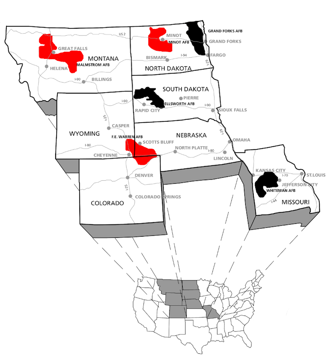
Durng the Cold War Intercontinental Ballistic Missile (ICBM) silos were placed throughout the United States, particularly in the upper Midwest. This map shows missile fields that are still active in red and ones that have been deactivated in black.

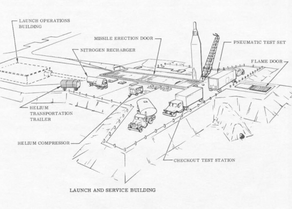
Here is a diagram of a typical missile site.

Topeka Regional Airport, formerly Forbes Air Force Base, became the home for an Air Force unit that conducted nighttime photography and mapping expeditions over Russia and other communist nations. In 1959 the Strategic Air Command ordered nine ICBM sites built surrounding the base. These were decommissioned in 1965 after the costs to maintain them became too high.

A description of the site at Worden Kansas (548-2 Lawrence) on the map above.            

"Today, weeds, bushes, and trees cover nearly the entire site and frogs cheerfully leap into the pond that has formed in front of the entry door to the old missile bay. At first glance, it appears that the site, once at the forefront of the nation’s nuclear arsenal, has been reclaimed by nature. Yet is still possible to recognize a few of the launch facility’s features, such as the different buildings and the doors that allowed the missile to be launched. These remnants speak to the profound environmental impact of the nuclear arms race, one that can still be felt today."