Thursday, October 30, 2008

Map of the Week-Election Cartograms

You may have heard that the US Presidential Election just is around the corner. The best way to see the true distribution of electoral votes is to use a cartogram. A cartogram is a map showing areas sized by some factor other than area (in most cases population). Cartograms are usually pretty ugly things.


They can be one-legged spiny monsters;


or they can be acid trippy lava lamps.


That's why when I'm shopping for a cartogram, I usually go with the more subdued kind that you get from a serious sedate publication like the New York Times. By the way - if these colors don't look right to you, change them! Many of these sites let you change the states to whatever color and pattern makes you happy.

Wednesday, October 22, 2008

Crap of the Week


John Krygier, a professor of Geography at Ohio Wesleyan University and DIY Cartography blogger created the Crestview Road Dog Sh*t Map for his street in Columbus, Ohio. It's kind of ugly but makes a point and I like the little steaming pile symbols. These days I pick up piles like that daily but obviously many dog owners don't bother.

Here's another crappy picture I stole from one of his blog entires - the NY City street grid in grout. OK enough bathroom humor, maybe next week we'll return to "cleaner" subjects. We'll see.

Thursday, October 16, 2008

Map of the Week-Holy Smokin' Smokies!

Outrage GIS produces recreational maps for the southern Appalachian Mountains. They have developed a trail atlas of the Great Smoky Mountains and give you an interactive look at the bird's eye view that appears in this atlas. Just use the little pan and zoom tools at the bottom to explore. Complete with fog for some extra realism!

Wednesday, October 8, 2008

Map Channels - Useful Content!

Map Channels is a service that lets you embed a custom map into your website or blog. In addition they have numerous "channels" to look at local events, book hotels and look at street views. They also have a nice function to compare Google Maps with Virtual Earth.
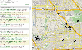
When you get past the flashy "cool" stuff there's actually some very useful functions here. Going to Los Angeles? Need to know what's happening? Below is a map of upcoming events. What's really nice about this is it's actually current to today! Usually these things are months out of date. Oh, and they have your city too. I know because I've checked.

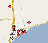
Need a hotel? Here's a map of available hotel rooms in San Jose del Cabo, Mexico. Click a dot and make the reservation!


Here's another cool "channel" - free things to do in London. OK so most of them are parks - I can live with that.

Thursday, October 2, 2008

Map of the Week-The Mural Arts Project

Driving through Philadelphia the other day we saw some pretty cool murals. I remembered that I had some info about the Mural Arts Program but had not been able to locate a comprehensive map. There are tour maps of the Center City Area but nothing showing the outer 'hoods. Upon further review I found muralBase created by the University of Pennsylvania's Cartographic Modeling Lab. You can choose a theme, artist, zip code or year and get a map showing the location of murals as well as descriptions and pictures about each one. Below is the map that results when you choose "Latino" as the theme - clustered in the Latino sections of town. On the right side is a mural of El Yunque - the rain forest in Puerto Rico.


Here's a nice one - Buckminster Fuller's Dymaxion Projection!